Located about an hour east of Winslow, Petrified Forest National Park (www.nps.gov/pefo/) boasts the largest concentration of petrified wood in the world. Not only does this Arizona gem offer some dazzling desert scenery, but it also includes a number of accessible trails and overlooks for wheelchair-users and slow walkers. And since the park is located right off Interstate 40, it’s an excellent addition to any Grand Canyon road trip.
The Basics
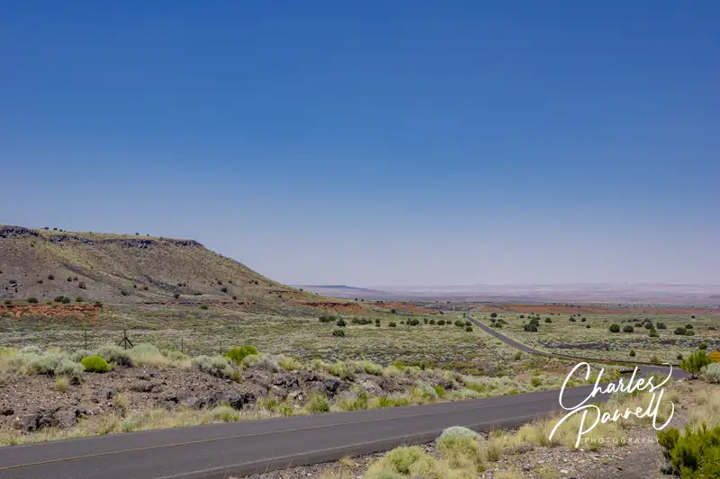
Windshield View on Highway 180
It’s easy to do a one-way jaunt through the park, stop at a few trails and viewpoints along the way, then reconnect to the highway and continue on your journey. If you’re traveling east, take the Highway 180 exit (exit 285) and use the south entrance of the park; and if you’re traveling west, take exit 311 and use the north entrance. Either way, after you’ve explored the 28-mile route, it’s simple to hop back on the interstate.
The whole drive takes an hour without any stops, and although there are some wonderful windshield views along the way, there are also some very scenic turnouts and sights that are definitely worth a stop. It should also be noted that the gates to this national park open at 8:00 a.m. and close at 5:00 p.m., so plan accordingly to avoid disappointment.
The Painted Desert Visitor Center, which is located near the north entrance, makes a good first stop in the park. Accessible parking is located near the entrance, with level access to the building. Inside there’s a small gift shop, a ranger information desk and accessible restrooms. Pick up a park map, then head out to explore this national treasure.
Views and More
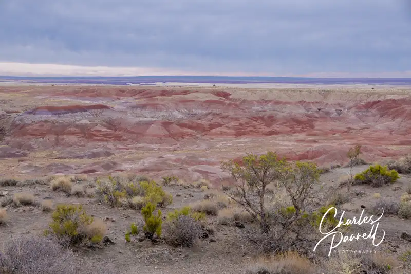
View at Tawa Point
Although there are no shortage of scenic views in the Petrified Forest National Park, make sure and stop at Tawa Point, just past the north entrance, for that first expansive view of the Painted Desert. Accessible parking is located near curb-cut access up to a short .1-mile paved trail out to the viewpoint. The last 20 feet of this path is a bit steep for manual wheelchair-users; however you can get a good view of the colorful desert from any place along the trail, or even from the parking lot.
The Painted Desert Inn, which is located just a half-mile up the road, is also worth a stop. This former Harvey House features accessible parking, and level access to the building. There inn houses a number of historic exhibits, but you just can’t beat the panoramic desert view from the second floor of this split-level structure. Additionally, there’s a 300-foot paved level pathway out to nearby Kachina Point, which offers an equally impressive desert view.
Painted Desert Inn
Another worthwhile stop is Puerco Pueblo, which is a few miles up the road, just past the railroad tracks. Accessible parking with curb-cut access up to the sidewalk is located near the accessible vault toilets. From there it’s about a 200-foot walk out to a .3-mile paved trail that circles the ruins of these ancestral Puebloan homes which were occupied from 1250 to 1380.
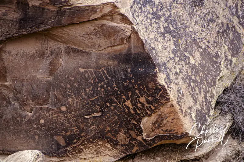
And don’t miss Newspaper Rock, which is short drive down the road. That site features a 200-foot paved level trail out to some Puebloan petroglyphs, which were created 2,000 years ago. There’s an accessible spotting scope at the overlook, which offers a good view of the 650-plus petroglyphs.
Petroglyphs on Newspaper Rock
Petrified Wood Galore
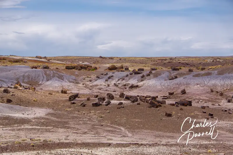
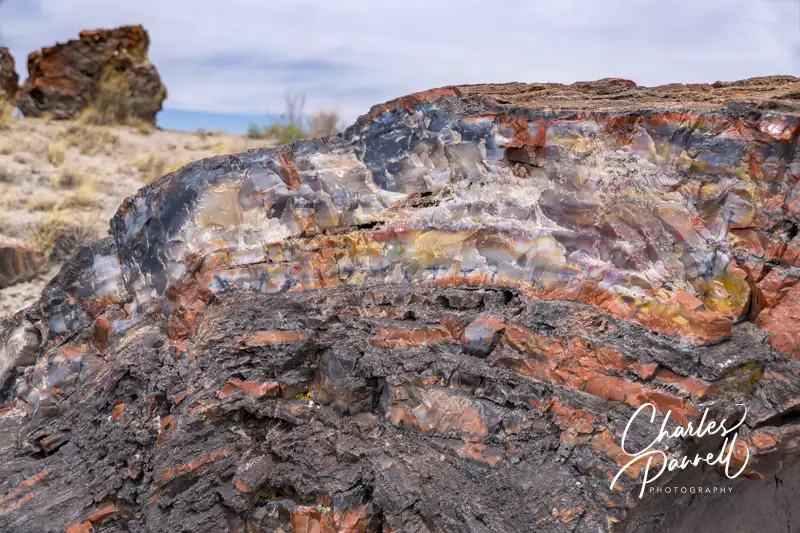
Crystal Forest
There’s also a substantial collection of petrified wood sites — such as the Crystal Forest — along the main park road. Although a paved .8-mile trail leads past the petrified logs at this site, it’s got a section or two of 20% grade, so it’s not a good choice for wheelchair-users and slow walkers. That said there is a 400-foot paved level path that leads out to the trailhead, that offers a good overview of the remains of this ancient forest.
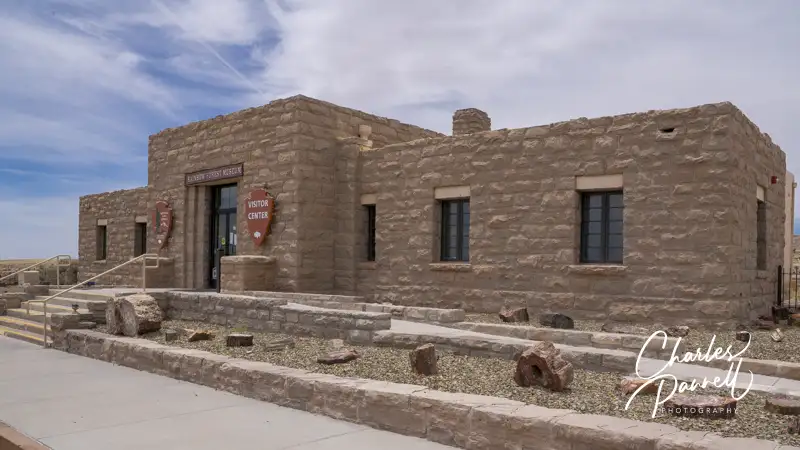
Rainbow Forest Visitor Center
Finally, don’t miss the Rainbow Forest, which is located just north of the south entrance. There’s accessible parking near the Rainbow Forest Visitor Center, with ramp access up to the front door. Inside there’s barrier-free access to the interpretive exhibits, ranger information desk and accessible restrooms. There’s also plenty of room for wheelchairs and scooters in the theater, where a movie about the park is shown throughout the day.
The Giant Logs Trail is located out back, and although this paved trail starts out level, the access ends 600 feet later at the Mather plaque, where steps block the rest of the route. Still, there’s a good view of the site from this point, or even from the back of the visitor center.
And if you’d like to grab a bite to eat before you hit the road, stop in at the curio shop at the far end of the parking lot. There’s level access to the shop, which offers snack items, gifts and souvenirs. All in all, Petrified Forest National Park is well worth the short detour off the interstate.
Petrified Tree in the Crystal Forest
Barrier-Free Travel the Grand Canyon for Wheelers and Slow Walkers
Population 2,769
Located along the post-1937 incarnation of Route 66, Santa Rosa is a must-stop for car buffs on any Interstate 40 road trip. The big draw is the Route 66 Auto Museum (www.facebook.com/Route-66-Auto-Museum-584173181695140/). The brainchild of Bozo and Anna Cordova — who also own Bozo’s Garage & Wrecker Service — is the result of Bozo’s lifelong love affair with automobiles. He built his first car when he was just 12, and subsequently Bozo and his crew have custom built over 150 different vehicles. These restorations, many of which required some “out of the box thinking” have been subsequently displayed in the museum. There’s accessible parking in front, with level access to the museum, and plenty of room for even the largest wheelchair to navigate around the displays. The collection dates back to 1920; and there’s also a good collection of old signs, Route 66 memorabilia, photos and vintage vending machines on display. It’s a great blast from the past.
If you’re cruising along Interstate 40 near Amarillo, Cadillac Ranch is a required stop. Located on South Frontage Road between Arnot and Hope Roads, this public art display was created by an artist’s collective called The Ant Farm. It features 10 Cadillacs planted nose first into the ground. Built along the remains of Route 66, they were meant to symbolize the “golden age” of the American automobile. The cars are routinely painted with graffiti and even dressed up on some holidays. And although the creator frowned on this practice at first, it’s now encouraged.
There’s just a wide spot on the road to park in front of Cadillac Ranch, but there’s plenty of room for an accessible van. The entrance gate has a 24-inch clearance, but after that there is a six-foot wide hard-packed dirt path out to the cars. And if you can’t manage the walk, you can still a good view from the road. This roadside attraction is a good appetizer for The RV Museum & Storage (emerginghorizons.com/jack-sisemor-rv-museum/) located up the road on Interstate 27.
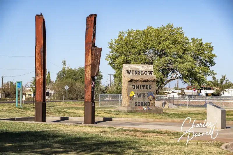
This modest 9-11 memorial is located at the east end of town, along historic Route 66. There’s accessible parking on both sides of the memorial, with a level sidewalk over to the viewing area, which contains two pieces from the wreckage of the World Trade Center. There’s ample evidence of the reverence of the site, as past visitors have left flags, messages and notes at the memorial. There’s also a medallion from the former Winslow Bridge which once spanned the Little Colorado River on Route 66, at the site.
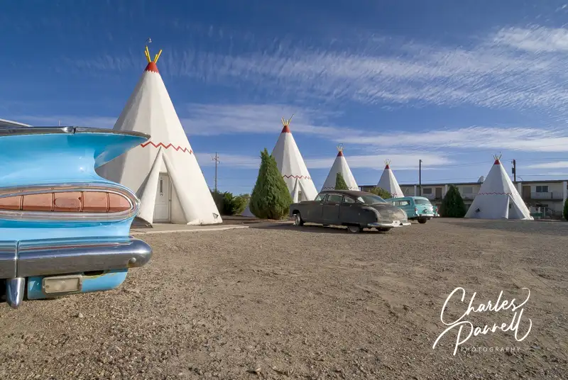
Over in Holbrook, Arizona, the Wigwam Motel is also worth a stop. Just take exit 285 and head east on Hopi Drive — trust me you can’t miss it. This hotel, which features 15 individual “wigwams”, first opened in the 1950s and was very popular in they heyday of Route 66. Although the Wigwam Motel is still in operation, they don’t have any accessible rooms. That said, it’s still worth a stop for the photo op, as there’s a nice collection of vintage cars parked in front of the wigwams. Access is good around the property too, as it’s all level. Additionally, the property is still owned by the same family that built it, and they love to chat about Route 66 history.
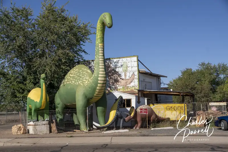
Although there’s no shortage of rock and petrified wood shops in Holbrook, the Rainbow Rock Shop is worth a stop, just for the photo op. Although the fenced yard is filled to the brim with rocks of every size and shape, the real stars at this stop are the giant fiberglass dinosaurs.
The best place to park is on the right side of the shop, which has a small paved unstriped lot, but parking is also available in a level gravel area in front. It doesn’t matter if the shop is open or not, because the real photo ops are from outside. Unfortunately the shop and the yard are so filled with rocks and petrified wood, that it’s not even remotely wheelchair-accessible. Still you can just pull up to the front to catch a glimpse of the dinosaur collection – you don’t even have to get out of your car. It’s easy to find too – just take exit 286 off of Interstate 40 and head south. The rock shop is located on the west side of the road just south of Hopi Drive.
Despite its foreboding name, Dead Horse Ranch State Park (https://azstateparks.com/dead-horse) is a pleasant place to visit. The unfortunate moniker comes from the Ireys family who came west in search of a better life in the 1940s. After several days of hunting for the perfect ranch, Mr. Ireys asked his kids which place they liked best. The children excitedly replied, “The one with the dead horse in front of it, dad.” And with that response, the family found a new home, and subsequently renamed it to mark the momentous occasion.
Thirty years later, when Arizona State Parks acquired the parcel, retention of the colorful name was a condition of the sale. Today there’s nary a dead horse in sight at this northern Arizona State Park. Instead you’ll find 423 acres filled with accessible trails, fishing and birding opportunities, and comfortable camping cabins. And since it’s just a one-hour hop off Interstate 40 from Flagstaff, it also makes a nice stop on a Grand Canyon visit, or even on a longer western national park road trip (emerginghorizons.com/western-national-park-road-trip-for-wheelchair-users-and-slow-walkers/).
A Birding Hot Spot
Juvenile American Bittern at Dead Horse State Park, Arizona
Dead Horse Ranch State Park is a prime birding spot in the spring and fall, and the headquarters for the Verde Valley Birding & Nature Festival in late April. A word of warning though — it’s too hot for birds or humans during the stifling summer months, so plan your visit accordingly. On the plus side, 180 bird species have been spotted in the park during the prime seasons, including loons, herons, egrets, eagles, hawks, hummingbirds, kingfishers, swallows and ducks.
The best place to get a glance of the avian residents is on the Canopy Trail, which begins in the day use area. Accessible parking is located near the trailhead, and although it’s a short walk from the cabins, there are stairs and other obstacles along the way, so it’s best to drive.
Canopy Trail at Dead Horse State Park, Arizona
The quarter-mile wheelchair-accessible trail has a hard-packed dirt surface and is covered in crushed granite. The wide level trail winds under a cottonwood canopy, so there’s also plenty of shade along the way. About half-way along the loop there’s a picnic table and a large collection of chairs under an enormous cottonwood tree. There are also a number of hummingbird feeders in the area, so it’s the ideal place to just sit back and wait for the birds to appear. And if you’d like to pack along a picnic lunch, there are also sheltered picnic tables on a cement pad near the accessible restrooms in the parking lot.
Visit the Lagoons
Fishing Pier on the Lagoon at Dead Horse State Park, Arizona
Another must-see in the park are the three lagoons located near the end of the main park road. Filled with water from the Verde River, these lagoons are stocked with catfish and trout, and feature accessible trails around them. The trail around the west lagoon is a third-mile long, while the trail around the middle lagoon measures nearly a half-mile. And if you’d prefer a three-quarter mile scenic stroll, then the trail around the east lagoon is just what the doctor ordered.
There’s plenty of accessible parking around all of the lagoons, with barrier-free access to the lagoon trails, which also act as levees. The trails are wide, level and composed of hard-packed dirt, and they are shaded by the trees along the shore. There are also several accessible fishing piers on each lagoon, that offer roll-on access and lowered rails. Additionally if you’d like a longer walk, the trails connect, so you can plan a round-trip hike around all three lagoons.
Spend the Night at Dead Horse Ranch
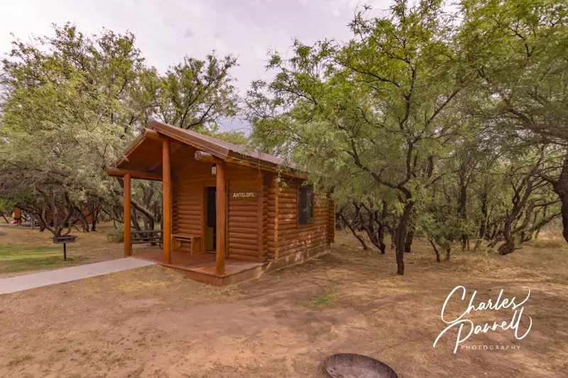
Antelope Cabin at Dead Horse State Park, Arizona
If you’d like to spend the night in the park, the camping cabins are a nice wheelchair-accessible choice. The cabins are pretty basic, but a definite step up from pitching a tent. Cabin 1 has a paved parking area in front, with level access up to the front porch.
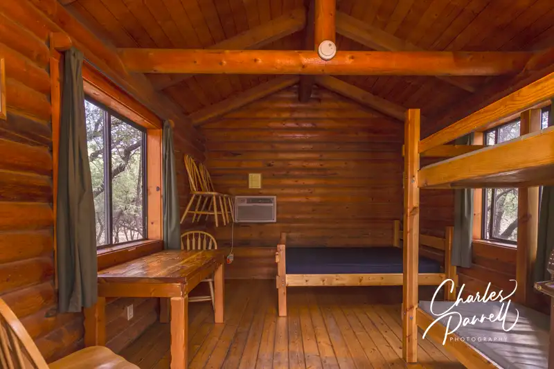
There’s a wide doorway and adequate wheelchair clearance inside the cabin. It’s furnished with a set of bunk beds and a double bed, a chest of drawers, a table and four chairs. The bunk bed is 17 inches high, while the double bed is 23 inches high; and they both offer wheelchair access on one side. Additionally, the chairs can be easily stowed on hooks when not in use, which frees up more floor space. The cabin also has electricity, overhead lights and an air conditioner.
Inside the Cabin 1 at Dead Horse State Park, Arizona
Outside there’s a picnic table on a level grassy area next to the cabin. There is also a fire grill near the table, and a bench on the porch. Cabins 2, 3, 5, 6, and 7 also have the same accessibility features.
The bathhouse is located a short walk away along the paved road. The large family restroom includes a roll-in shower with a fold-down shower bench and grab bars, plus a toilet with grab bars on the back and right walls (as seated), and a roll-under sink. . There’s no hand-held showerhead; and as a water conservation measure a one-to-two minute water spurt is released when the shower knob is pressed. Still it’s doable for most folks.
Bathhouse near Cabin 1 in Dead Horse State Park, Arizona
In the end, no matter if you overnight or just stop by for the day, this often overlooked Arizona state park is a definite must-see.
Barrier-Free Travel California National Park Road Trips for Wheelchair-Users and Slow Walkers
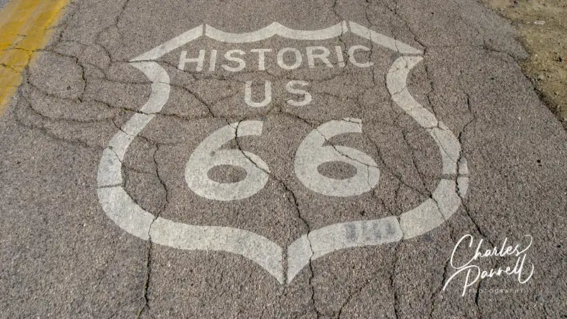
Route 66 — which ran from Chicago to Los Angeles — was given its official numerical designation in 1927. Back then it was just a new moniker for a network of roads that crisscrossed the nation. As Americans embraced road trips in the early 1930s, the route blossomed. Motor courts, diners and roadside attractions sprung up along the way, and business was booming. Nicknamed the Mother Road by John Steinbeck, Route 66 also beckoned Dust Bowl residents to head west in search of prosperity.
Today this historic route has been largely replaced by Interstate 40, however it’s still possible to drive along a few sections of the original Mother Road in Arizona. And although it’s a historic route, it’s still a viable option for wheelchair-users and slow walkers. So hop off the interstate on your next drive through the Grand Canyon State, and experience a taste of a wheelchair-accessible Route 66 road trip.
The Oatman Highway
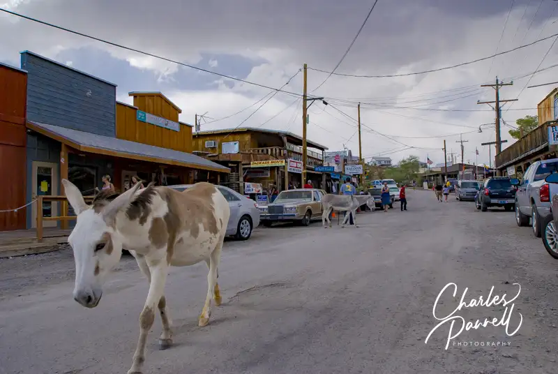
Burro in Oatman, Arizona
This historic route begins on the Oatman Highway. Just take the Topock exit from Interstate 40 after you cross over the Colorado River and enter Arizona. This part of your wheelchair-accessible Route 66 road trip winds through the Black Mountains, crosses Sitgreaves Pass and offers remnants of a bygone era.
Oatman (www.oatmangoldroad.org), which was founded in 1906 to support nearby gold mining camps, is located 35 miles up the road. Today the town celebrates its rough and tumble past and retains a distinctive wild west flavor. Daily gunfights are held in front of the Oatman Hotel (check the town website for times). Accessible parking is located near the Post Office and there are accessible public restrooms on the east end of town.
And then there are the burros. Years ago the miners used burros to work the gold mines, and today their descendants roam the streets of Oatman. A word of warning — watch were you walk or roll because there are a lot of them. And if you’d like to feed them, there’s no shortage of places that sell burro food. All in all, Oatman is a fun stop, and although some of the shops have steps, there are also restaurants, stores and attractions that have level access.
After you leave town, the narrow road winds up to Sitgreaves Pass. Hairpin turns and sheer drop-offs are the norm on this stretch of the route, and there’s also a noticeable lack of guard rails along the way. On the plus side, there’s no shortage of spectacular windshield views, including one at the summit, and another on the way down near the Mile-30 marker.
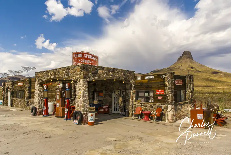
Cool Springs
Cool Springs, Arizona
As you continue on this wheelchair-accessible Route 66 road trip, the road winds down Gold Hill and passes the remnants of Ed’s Camp, before it reaches Cool Springs. Barely a wide spot in the road, this rest stop was a welcome sight to road weary travelers back in the day. Hollywood also discovered it in 1992, when it was used as a filming location for Jean-Claude Van Damme’s Universal Soldier. Sadly it was demolished in the final scenes of the movie; however it was later sold and rebuilt to resemble the original 1926 incarnation.
Parking is available in a level dirt area, with barrier-free access to the main entrance of the gift shop and museum. And even though there is one step inside, there’s also access to the raised area of the building from a second accessible entrance.
The makeshift museum offers up a quirky collection of found objects that includes everything from an old gas pump and tools, to oil cans, photos, toys and even vintage post cards. There’s also a t-shirt shop, jewelry counter and a decent selection of Route 66 souvenirs peppered around the memorabilia. Outside, there’s an old 1935 rusted out Nash Sedan to the left of the store. And of course the old gas pump which rests under a restored stone canopy.
Kingman
The Powerhouse Museum in Kingman, Arizona
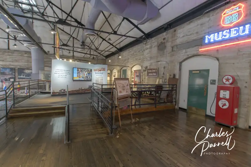
It’s about a 25-minute drive from Cool Springs to Kingman — the largest city on this wheelchair-accessible Route 66 road trip. The road straightens out and parallels Interstate 40 before it enters town. After that, it turns to the right at the Powerhouse, and becomes Andy Devine Avenue.
The Powerhouse is definitely worth a stop as it’s home to the Powerhouse Route 66 Museum (www.explorekingman.com/attraction-Powerhouse-Route-66-Museum).
There’s elevator access to this kitschy museum, which is located on the second floor. Highlights include information on the Dust Bowl immigrants and the origin of the ubiquitous Burma shave signs. The Historic Route 66 Association of Arizona also has a room filled with exhibits and information about the era. Top it all off with a 1950 Studebaker, and some vintage storefronts, and you get a real feel for the era.
And if you’d like to grab a bit to eat in a nostalgic diner, then stop in at Mr. D’z Route 66 Diner, which is just across the street. Accessible parking is on the side with level access to this retro eatery, which is famous for their burgers and ice cream confections.
After lunch, continue east on Andy Devine Avenue. After you pass the airport, the road narrows to two lanes and transitions to the remnants of Route 66. Along the way you’ll pass vintage Burma Shave billboards, roadside attractions and some fun photo ops. As an added bonus, this section of your wheelchair-accessible Route 66 road trip is fairly level and straight.
Hackberry
The Hackberry General Store
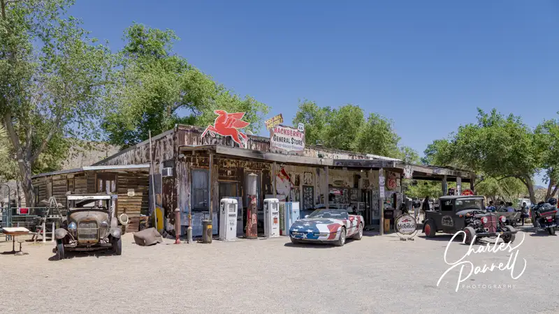
About a half-hour down the road you’ll come upon Hackberry, home of the Hackberry General Store (www.facebook.com/profile.php?id=100043125116622). This restored building features a vintage gas station, a souvenir shop and another great photo opportunity. There’s just a dirt parking area in front, but it is level and there’s usually plenty of room to parallel park an adapted vehicle.
Outside, there’s a treasure trove of memorabilia including some rusted out old cars, signs, tools and even a mock-up of a vintage garage. There’s level access to the store which offers souvenirs, cold drinks and snacks. And although the restrooms are not accessible, the men’s room is worth a look as it’s tastefully decorated with vintage pinup posters. Even if you can’t go all the way in, take a gander at the interior from the doorway.
Valentine
Accessible Tram at Keepers of the Wild Animal Park
The tiny hamlet of Valentine is just five miles up the road. If the landscape along this stretch of the road looks familiar, it’s because the tire change scene from Easy Rider was filmed there. Although there are a few remnants of an old hotel and gas station in Valentine, the big attraction is Keepers of the Wild (www.keepersofthewild.org).
Keepers of the Wild houses over 150 exotic and indigenous animals that were rescued or abandoned. This non-profit animal sanctuary has a strict no breeding policy, with a strong focus on advocacy, education and protection. As part of their educational outreach, the facility is open to the public, and all admission fees go directly to the care of the animals.
Although visitors are welcome to walk around the sanctuary and check out all the habitats, the best way to learn about the animal residents is to also book a Guided Safari Tour. The standard safari tour vehicles are not wheelchair-accessible, but an open-air wheelchair accessible tram is used for wheelchair-users. There’s room for two wheelchairs aboard the the tram, and it’s also a good option for slow walkers who can’t access the traditional safari vehicle.
The tram tours are conducted several times each day; however the prime tour time is at 3:30, as that’s feeding time for the animals. The tour guides are great about pointing out natural animal behaviors and answering questions, but they also tell fascinating tales about how some of the current residents came to the facility. Save some time to explore the sanctuary on your own too. Some of the lower dirt pathways are accessible in good weather. It’s a great attraction, and the staff is well versed in access issues.
Peach Springs
Hualapai Cultural Center in Peach Springs, Arizona
Next up on your wheelchair-accessible Route 66 road trip is Peach Springs, which is just 20 minutes east of Valentine. Located on Hualapai land, it boasts a hotel, a restaurant, a gas station, a cultural center, and a few vintage buildings.
Built on the site of the Qumacho Cafe, the Hualapai Cultural Center may be of interest to some folks. Accessible parking is available on a concrete slab on the left of the building, with level access to the front door. Although there’s no formal tour, the receptionist is happy to show visitors around and answer questions. The cultural center features a nice collection of native artwork, as well as baskets, pottery and other items created by the young people of the tribe.
Remnants of the past can be seen at the Osterman Gas Station, which is located between the Hualapai Cultural Center and Hualapai Lodge. This former Shell station, which was built by Oscar Osterman in the 1920s, did a robust business during the boom days of Route 66. Sadly when the Mother Road was decommissioned, business died off and eventually the business was closed. The building was placed on the National Register in 2012.
Located across the street from the historic Osterman Gas Station, Walapai Market features level access and includes a deli, a bakery and a wide selection of grocery items. And, if you’d prefer to sit down and take a break, the Diamond Creek Restaurant at nearby Hualapai Lodge offers a menu filled with Native American specialties and traditional American favorites. Either way, you won’t go away hungry.
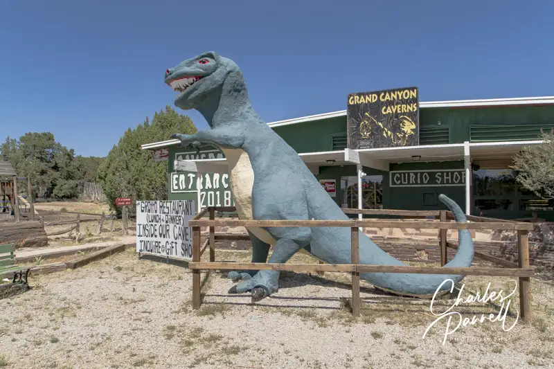
Grand Canyon Caverns
Grand Canyon Caverns
Grand Canyon Caverns (gccaverns.com) which is just 10 minutes down the road is also worth a stop. A large sign marks the entrance to the mile-long flag-lined road that leads to this family-owned attraction. Take a few minutes to have a look at the vintage automobiles near the beginning of the road that’s aptly named Radiator Springs.
Although there’s no accessible parking at Grand Canyon Caverns, the large lot is paved, and there’s usually plenty of room to parallel park an adapted van. And don’t forget to snap a photo of the large dinosaur that guards the entrance to this vintage attraction. From the parking area, there’s level access over to the ramped entry to the restaurant, and barrier-free access to the ticket counter next door.
Although none of the cavern tours are technically wheelchair-accessible, the 45-minute guided tour may work for some wheelchair-users and slow walkers. This tour travels about a quarter-mile on paved trails, and although manual wheelchair-users may need some assistance with some of the grades, it’s doable for some folks. There’s elevator access down to the cavern entrance, and although there are 15 steps at the beginning of the tour, there’s also an alternate step-free route. It’s best to check the website before making plans as the tours are not always offered, but it’s still a fun stop without the tour.
Even if you don’t do the tour, be sure and stop in for a bite to eat at The Caverns Grill, which offers a nice selection of homestyle meals and of course cheeseburgers, fries and yummy desserts.
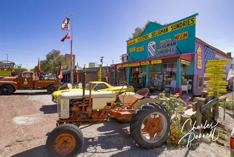
Seligman
“Downtown” Seligman, Arizona
Known as the birthplace of the “preserve Route 66 movement”, Seligman (seligmanazchamber.com/visit-seligman) is located about a half-hour from Grand Canyon Caverns, at the end of the east section of Route 66. It’s the home town of Angel Delgadillo, the founder of the Historic Route 66 Association, and the man who spearheaded efforts to restore part of the Mother Road.
Street parking is the norm in Seligman; but the good news is that sidewalks and curb-cuts have been added for better access. Many of the historic buildings have been converted to gift shops, and although a few have a step or two at the entrance, a good number of them also offer level access. It’s fun to just stroll down the street and look at the different storefronts. Make sure and stop in at Degadillo’s Snow Cap (www.facebook.com/p/Delgadillos-Snow-Cap-100063560350919/) which was built from scrap lumber by Juan Delgadillo in 1953. There’s level access from the street to the counter — where you can place your order — and plenty of room for a wheelchair or scooter on the large patio dining area.
There’s also a nice collection of vintage cars behind the restaurant in a level area, as well as more tables for overflow dining. From Seligman, you can easily hop back on Interstate 40 and continue your drive through Arizona. And if you’re headed to the Grand Canyon (emerginghorizons.com/grand-canyon-national-park/), it’s less than two hours away from the end of this wheelchair-accessible Route 66 road trip detour.
Barrier-Free Travel the Grand Canyon for Wheelers and Slow Walkers
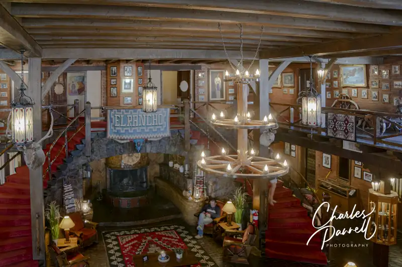
Built in 1936, the El Rancho Hotel entices prospective guests with the phrase “The charm of yesterday and the conveniences of tomorrow” emblazoned across its front portal. The main building is constructed largely of brick, with stone and wood finishing touches. Inside it’s like a step back into another century – from the vintage shoe shine stand to the cigarette machine near the front door. Add in the lush bordello-like furnishings and the massive wood staircase, and you have a real blast from the past.
And even though access wasn’t an issue when the property was built, there’s an accessible parking space near the front entrance, with curb-cut access up to the porch. From there, it’s an easy roll inside the lobby. There’s also a small gift shop and restaurant on site, if you’d like to extend your stay. Unfortunately the elevator up to the mezzanine gallery looks like it hasn’t worked for decades, so the only way to view the portraits of the stars that stayed there is to climb the stairs. Still, it’s worth a quick stop just to see the outside of the building and the front lobby, which has a few display cases filled with film memorabilia. And it goes without saying, that it’s a must-see for movie buffs, as the El Rancho Hotel was once home base to the movie stars that filmed westerns in the area.
827 Montoya Boulevard
Gallup, NM
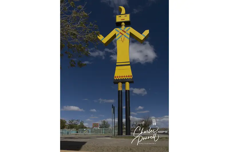
A must-stop along Interstate 40 is the Giant Kachina in Gallup, NM. At one time this classic Route 66 icon welcomed weary travelers to Gallup, but sadly the welcome signs are gone today. Just take exit 22 from Interstate 40, drive north on Ford Drive, then make a left on Montoya Boulevard. The statue is on the right, next door to the Fire Prevention Office, There’s plenty of room to park, and a nice level area to get out and take in this beauty. There are even a few covered picnic tables in the parking lot if you’d like to take a longer break. And while you’re in the area, don’t miss the historic El Rancho Hotel (www.emerginghorizons.com/el-rancho-hotel)