If you’re planning to visit some Washington State Parks in 2026, and you want to save a few bucks, then plan your visit for one of the fee-free days. Normally a Discover Pass is required in order to enter Washington State Parks, but on these 2026 dates you don’t need a pass and you don’t need to pay an entry fee.
Thursday, Jan. 1 – New Year’s Day and First Day Hikes
Monday, Jan. 19 – Martin Luther King Jr. Day
Monday, March 9 – Billy Frank Jr.’s Birthday
Thursday, March 19 – State Parks 113th Birthday
Wednesday, April 22 – Earth Day
Saturday – Sunday, June 6-7 – Free Fishing Weekend
Friday, June 19 – Juneteenth
Sunday, Aug. 9 – Smokey Bear’s Birthday
Saturday, Sept. 26 – National Public Lands Day
Saturday, Oct. 10 – World Mental Health Day
Wednesday, Nov. 11 – Veterans Day
Washington has a lot to offer state-park wise, and here are some of our favorites. And we’ve really been impressed with their wheelchair access too.
If you’d like to visit a Washington State Park at other times during the year, and you happened to have a disability, then you can get a free Washington State Disability Pass. This pass can be used in place of a Discover Pass. Pass holders get the following benefits at Washington state lands.
Free parking and entrance to all state parks (no Discover Pass needed)
The form is pretty simple to fill out, but you do need to submit a few things with it.
Proof of Residency
This can be your drivers license or a Washington state ID card, but it must list your Washington address. You must be a Washington resident for at least three consecutive months in order to apply.
Proof of Disability
A copy of an accessible parking placard (not expired) is acceptable for proof of disability. If you don’t have that, then an eligibility letter for state or federal disability benefits will suffice.
There’s no charge to apply for the pass, and it’s good for either one or five years. So get yours today, and start exploring the accessible Washington national parks.
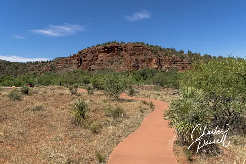
There’s a certain seductive allure to Sedona. Some folks come for the mystical experience, while others enjoy gallery hopping. And then there’s the scenery. You just can’t beat the red rock formations that literally surround this Northern Arizona enclave. And the good news is, a good chunk Sedona’s red rock beauty is accessible to wheelchair-users and slow walkers.
Red Rock Scenic Byway
Red Rock Scenic Byway
One of the best ways to enjoy Sedona’s red rock beauty is to take a drive on the Red Rock Scenic Byway. This popular route is located off of Interstate 17. Just take exit 298, and once you cross the Dry Beaver Creek bridge, the show begins.
The 7.5 mile scenic drive, which winds through the majestic landscape, is often referred to as a “museum without walls”. As you pass Oak Creek Village, the scenery becomes more dramatic. Bell Rock, one of Sedona’s four vortices, is located just past Oak Creek Village on the right. You can’t miss it. Bell Rock is one of the more accessible red rock formations, as the upper part of Bell Rock Trail is wide, level and made of hard-packed dirt. It’s doable for most wheelchair-users, however you can also get a great view of the iconic formation from the parking lot overlook.
Be sure to stop at nearby Courthouse Butte to admire the expansive scenery. And don’t miss the Chapel of the Holy Cross (chapeloftheholycross.com), which is built into the red rock buttes. There are a few accessible parking spots near the sanctuary, and golf cart transportation is available from the remote parking area. The chapel features ramp access, but some manual wheelchair-users may require assistance because of the pitch. Still it’s worth a stop even if it closed, just for a view of the impressive front facade.
Just up the road, the Red Rock Scenic Byway ends at Highway 89A. All in all it only takes 20 minutes to drive the route, but allow for extra time for lots of photo stops. And even though a Red Rock Pass is required for hikers, it’s not required for quick photo stops of 15 minutes or less.
Red Rock State Park
Mesquite Interpretive Loop
Red Rock State Park (www.azstateparks.com/red-rock), which is located on Highway 89A South is also worth a visit. There are a two accessible trails in the park, but they don’t offer much shade, so it’s best to go early in the day.
Accessible parking is located near the visitor center, with ramp access down to the building. Inside there’s plenty of room to maneuver a wheelchair around the gift shop, ranger information desk and interpretive exhibits. Accessible restrooms are located near the front door, and there’s also level access to the theater and classroom next door. And don’t miss the hummingbird garden on the back patio.
The accessible Mesquite Interpretive Loop begins near the parking lot. This short trail features a paved level pathway around garden filled with native plants. There’s a shaded picnic area with accessible tables near the trail; and there’s also a shade structure located in the middle of this quarter-mile trail.
The longer Bunkhouse Trail begins behind the visitor center. Although you can access it from the parking lot, that pathway has a steep grade. Alternatively, there’s level access to the trail from the hummingbird garden. The paved trail is fairly level, although there’s a bit of a grade in the beginning. Power wheelchair-users won’t have a problem, but some manual wheelchair-users may require assistance. There are also some cracks along the paved trail, but other than that it’s fairly smooth rolling.
At about the .2-mile mark there’s an accessible hard-packed dirt trail down to the Kingfisher Bridge, which provides a pleasant — and shaded — view of Oak Creek. From there a hard-packed dirt path follows the creek for another .2 mile before the trail loses its access. All in all it’s a pleasant mile-long out-and-back hike.
Slide Rock State Park
Pendley Homestead House on the Pendley Homestead Trail
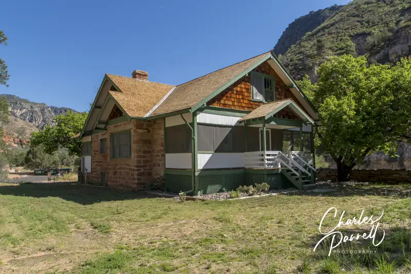
Finally, if you’d like to hit a local favorite, head on over to Slide Rock State Park (azstateparks.com/slide-rock). It’s located 20 minutes north of Red Rock State Park on Highway 89A. This park provides access to Oak Creek, and it takes its name from the rocks that many folks use as slides to get into the water.
Unfortunately the path down to the creek is not accessible, but there is a short trail that offers a scenic overlook of the canyon. That said, the admission is pretty steep ($20 to $30 per car, depending on the season) for just that trail; however if you have an Arizona State Park Pass, this park makes a nice lunch stop.
There’s accessible parking near the shaded picnic area — which has several accessible tables — and barrier-free access over to the Pendley Homestead Trail. This paved level trail leads past a small store, and by a display of vintage farming equipment, over to the old homestead which features a tractor display in the adjacent barn.
The trail then connects with the Cliff Top Trail which has a 75-foot paved path out to an accessible overlook that offers an expansive view of Oak Creek Canyon. All in all it’s about a quarter-mile round trip, and it makes for a nice stroll before of after lunch. And if you’d prefer to skip the hike, this piece of Sedona’s red rock beauty is easily visible from the the picnic area.
Barrier-Free Travel the Grand Canyon for Wheelchair-users and Slow Walkers
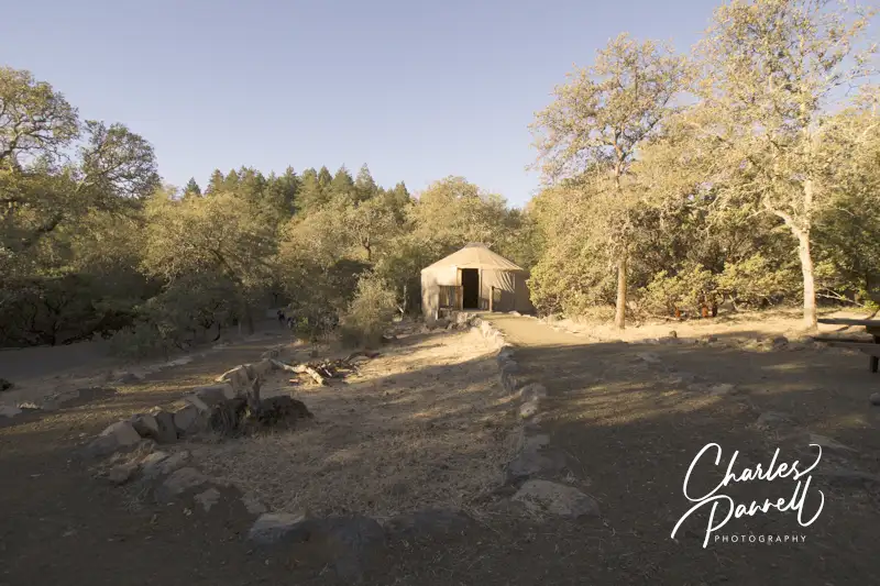
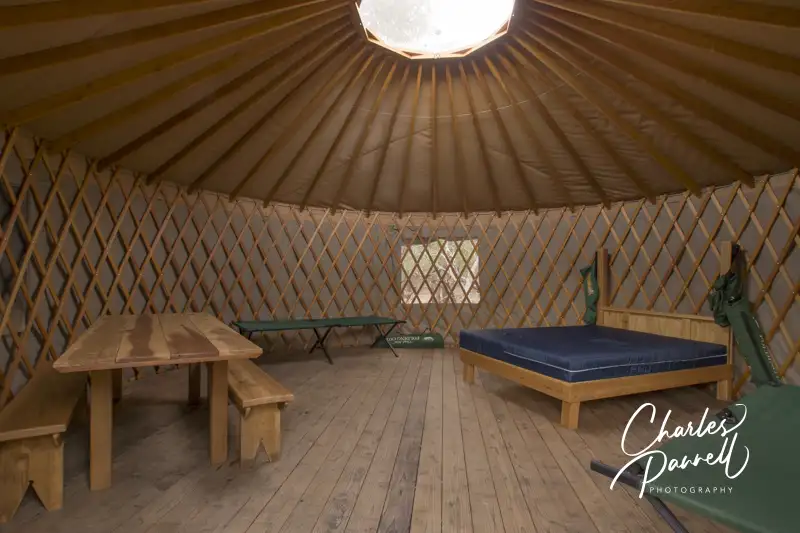
Located along the St. Helena Highway, Bothe Napa State Park (napaoutdoors.org/parks/bothe-napa-valley-state-park/) is easy to overlook, especially if you’re winery hopping along this popular Napa County thoroughfare. That said, it’s not only a nice place to stop for a picnic or to enjoy a short hike; but if you’re up for an adventure, it’s also an excellent place to overnight. Although the park offers wheelchair-accessible campsites, it also boasts a comfortable wheelchair-accessible yurt. Granted, this yurt is pretty basic — some would even describe it as rustic — however it provides a quiet, off-the-beaten-path lodging option in what can often be described as a crowded and overly congested area of the state.
Sleeping in a Wheelchair-Accessible Yurt
Inside Yurt 26 at Bothe Napa State Park
There are two campgrounds and yurt areas in the park, but this accessible yurt (26) is located away from the Group Campground, in the quieter Ritchey Creek Campground. There’s plenty of room to park on a level dirt pad in front of Yurt 26, with ramp access up to the front door. Access features inside the yurt include a wide doorway, wooden floors and ample space to navigate a wheelchair. Furnishings include a 21-inch high queen-sized bed with wheelchair access on both sides, four folding cots, and a table with two benches.
You’ll need to supply your own bedding, sleeping bags, pillows and towels; and since the yurt lacks electricity it’s also a good idea to pack along a lantern, flashlights and a camp stove. And although the mattress is certainly adequate, if you prefer more support you might also want to bring an air mattress.
Outside, there is a short accessible path over to a picnic table and a storage locker. It’s the perfect place to enjoy the outdoors, sip some wine, and relax as the sun sets. As an added bonus, it’s also very dark in the park, and with no ambient light you can really enjoy the night sky.
The bathhouse is just a short walk away. A family restroom with a roll-under sink and toilet grab bars is located in the front section of the bathhouse, while the private pay showers are located on the side. The accessible shower room includes a roll-in shower with grab bars, a built-in shower bench and a lowered showerhead. There’s plenty of room for an attendant in the large shower room, and it also features a spacious changing area with lowered hooks.
A Nice Picnic Stop
Picnic Grounds at Bothe Napa State Park
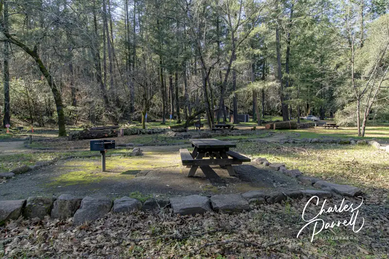
Even if you don’t spend the night in the wheelchair-accessible yurt, make plans to stop in for a picnic lunch and explore the park. The bulk of the accessible picnic tables are located in the day use area, which is located just down the park road from the visitor center. Accessible parking is located near the tables, with paved pathways to the tables and the accessible restrooms. If you’d prefer a more secluded repast, drive all the way to the end of the park road, park in the accessible parking spot, and feast at one the tables in the level shaded area.
Pioneer Cemetery at Bothe Napa State Park
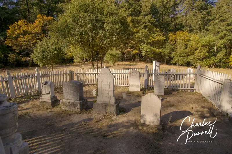
Save some time for a short walk to the Pioneer Cemetery on the accessible trail, which begins near the picnic tables at the end of the road. The hard-packed dirt loop winds around the restored graveyard, which dates back to the mid 1800s. There are benches to sit and rest along the way, while you gaze at the plots surrounded by quaint white picket fences. The trail then loops back through the woods to the site of the historic White Church, before it returns to the picnic area.
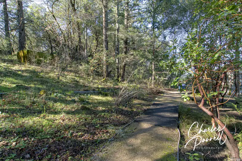
Last but not least, make sure and stop at the Native American Garden, which is located on the left side of the visitor center. The accessible pathway begins near the back of the building and winds through a natural garden filled with plants that were important to the first people of the area — the Wappo. Although a few of the species are labeled, the visitor center also has a plant guide to enhance your understanding of the native people. It’s just a short trail — only 150 yards or so — but it’s a pleasant stroll to top off your Bothe Napa State Park visit.
Trail to the Native American Garden at Bothe Napa State Park
Barrier-Free Travel California National Parks Road Trips Travel Ideas for Wheelchair-users and Slow Walkers
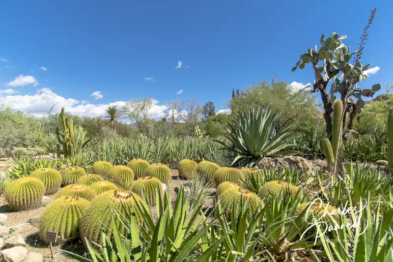
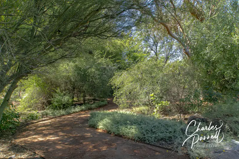
Located three miles west of Superior, Boyce Thompson Arboretum (btarboretum.org) is Arizona’s oldest and largest botanical garden. The 323-acre parcel is filled to the brim with plants from deserts around the world, and offers visitors an up-close-and-personal look at desert flora and fauna in the a variety of landscapes. From sheer mountain cliffs to a streamside forest, there’s a wide selection of habitats for wheelchair-users and slow walkers to explore. And since the park is just 65 miles east of Phoenix, it makes an excellent day trip from the city, as well as a fun Arizona road trip stop.
Plan a Picnic
Butterfly in the Demonstration Garden
Access is relatively good throughout this popular Arizona botanical garden, with accessible parking in front and barrier-free access over to the visitor center. Inside, there’s plenty of room to maneuver a wheelchair around the exhibits, and to the accessible restrooms, which are located in the rear of the building. There’s also barrier-free access to the gift shop, which offers souvenirs, gifts, drinks, snacks and sandwiches.
If you’d prefer to bring you own picnic lunch, accessible picnic tables are located near the Demonstration Garden, across from the visitor center. Accessible parking is located nearby, with a level path over to the shaded tables. It’s a pleasant, peaceful spot to enjoy a noontime repast.
Save some time to visit the Demonstration Garden after lunch. There’s level access throughout the garden which offers design and plant selection ideas for a variety of landscapes. Before you set out to explore the rest of the botanical garden, make sure you have an ample supply of water and a hat, as shade is in short supply, and the midday sun can be harsh.
Explore the Main Trail
Most of the Main Trail through the botanical garden is doable for wheelchair-users and slow walkers, as this hard-packed dirt trail is wide and fairly level. It begins near the visitor center and allows visitors access to a number of other gardens along the route.
The nearby Heritage Rose Garden also level pathways, and even though they are made of brick they’re still manageable. And don’t miss the Children’s Garden which features level access and boasts a fun water feature. The Taylor Family Desert Legume Garden is another good choice, as it’s is paved and showcases plants from the pea family. And although the trails in the outdoor Cactus Garden are a bit steep and bumpy, there are a few areas near the Main Trail that are doable for wheelchair-users and slow walkers.
The accessible section of this part of the Main Trail ends in about a mile, near Ayer Lake. From there it travels through the Upper Sonoran Natural Area, which has steep grades and a rocky pavement.
Another Main Trail Branch
Along the Main Trail at Boyce Thompson Arboretum
Even though Ayer Lake is the end of the line for one accessible trail, there’s still more for wheelchair-users and slow walkers to explore. From Ayer Lake, you can also double back and explore another branch of the main trail. Just head back toward the Taylor Family Desert Legume Garden, and connect to the other part of the Main Trail loop.
This section of the trail first trail passes through a patch of eucalyptus forest, with level pathways around the trees. The Herb Garden, which is just up the trail, is also fairly level, with plenty of room for wheelchair-users and slow walkers to navigate around the aromatic herbs. Just past the Herb Garden there’s barrier-free access to the suspension bridge, but the High Trail on the other side of the bridge is not accessible. The access on the Main Trail ends just past the pumphouse, where the trail connects to the rugged Upper Sonoran Natural Area.
All in all it’s about a three-mile round trip jaunt from the visitor center to Ayer Lake, over to the the Main Trail branch, and back to the visitor center. That said, if that’s too long, you can always explore the gardens near the visitor center, which offer a good overview of desert habitats. Either way Boyce Thompson Arboretum makes a fun and educational day trip for wheelchair-users and slow walkers.
Barrier-Free Travel the Grand Canyon for Wheelers and Slow Walkers
Track chairs are now available for loan at many Louisiana State Parks. Outfitted with tank tracks, these all terrain power wheelchairs allow folks to navigate trails that standard wheelchair can’t handle.” These specially-designed all-terrain chairs can really open up a world of new experiences for people with limited mobility,” said Lieutenant Governor Billy Nungesser. The track chairs were purchased with donations made to the Louisiana Park Foundation.
The Louisiana State Park track chairs are available at the following locations.
Fontainebleau State Park
Bogue Chitto State Park
Jimmie Davis State Park
Lake D’Arbonne State Park
North Toledo Bend State Park
Port Hudson State Historic Site
Sam Houston Jones State Park
Louisiana State Arboretum
Reservations for the track chairs must be made at least 48 hours in advance. The user must be accompanied by a companion that is at least 18 years old, and both the user and the companion must present a photo ID when picking up the track chair. A liability waiver must also be signed in order to borrow a track chair. Additionally, users under 16 must wear a helmet while operating the track chair.
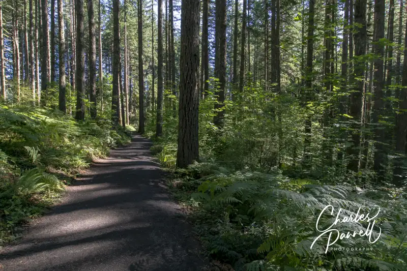
Located about 20 miles southeast of Salem, Silver Falls State Park is the crown jewel of the Oregon State Park system. There’s no shortage of majestic waterfall views, and if you’d like to get a closer look, there are also several wheelchair-accessible trails to explore. Add in accessible picnic areas, restrooms, food service and visitor facilities, and you have the complete package. And if you’d like to spend a few nights, there’s a nice selection of wheelchair-accessible cabins nears the rivers edge. So pack the car and get ready to experience a cornucopia of natural beauty at Silver Falls State Park.
South Falls District
South Silver Falls
The South Falls District is the most developed area of the park. It features accessible parking in the main lot, near the accessible restrooms and the information board. A wide paved trail leads to the left past the South Falls Café to the stone circle. From there bear left and continue along past the Nature Store. Take the next left and follow the trail out to the viewpoint. This is the closest view of the South Falls, and it’s about .25 from the parking lot. There is a small wall along the rim, and depending on the season some foliage may obstruct your view, so continue along the paved trail for a better vantage point.
After you return to the main trail, take the next left for a better falls view. This viewpoint is about .3 from the parking lot, and a bit downhill, but there’s a bench and a clear view at the end.
The trail past this point is not accessible, but if you head back towards the parking lot you can see the other side of the area. This time, take the right trail from the parking area and wind around the back of the South Falls Cafe and past the second set of restrooms to the Stone Kitchen Shelter on the right. Constructed by the CCC in 1936, this community kitchen was renovated in 2005. There’s an accessible pathway that leads past a picnic area to the right and up to the kitchen, and bypasses the steps in front.
And just past the Stone Kitchen Shelter, there’s a nice accessible boardwalk that winds through the forest. The access ends after the boardwalk, but it’s still a nice little jog through the forest. And a pleasant place to have a picnic lunch.
North Falls District
The North Rim Trail in the North Canyon District
The North Canyon District also has some accessible features, as this area recently underwent a major renovation. It’s located just past the north entrance to the park, and it should not be confused with the North Falls parking area, which is located further south along the road.
There’s accessible parking in the large lot with level access to the accessible restrooms and picnic area. There are a number of tables on the grass under the trees, plus one accessible table near the parking lot with an accessible drop-off are nearby. There’s no shortage of picnic choices here.
The North Rim Trail begins just to the left of the restrooms. This wide hard-packed dirt trail is covered with crushed rock in the beginning, and then transitions to a dirt trail. It winds through the forest and passes the North Canyon Nature Play Area, where kids can play on nature-themed play equipment. There’s also another picnic area along the route, which is in a level dirt area and has room at the end of the tables for wheelchairs. It’s a more secluded option than the main picnic area.
The trail continues along through the forest, crosses a bridge and has a minimal elevation gain. At about the .6-mile point, there’s an accessible viewpoint with an interpretive plaque and a nice view of the North Falls. After that the trail loses its access, as there are steps, ruts, and elevation gains. Still it makes for a nice 1.2-mile out-and-back hike through the forest, and it offers a great view at the end.
A Taste of Mother Nature
South Falls Trail
The South Falls Campground also boasts a doable trail for many folks. You can access the trail in two places — near the campground entrance and campsite 2, or near the amphitheater and campsite 41. The entrance near campsite 2 has a bridge with about a three-inch step, but there is also an alternate entrance from the campground road.
The whole trail is about 1.25 miles long, but only the end sections are doable, as the middle has narrow pathways, rocks and other obstacles, steep sections and some overgrown foliage. From each entrance the trail is doable for about .4 mile. These sections boast a wide trail in good repair, that meanders along a stream and through the forest with a minimal elevation gain. It’s a good trail for birders, as there’s no shortage of wildlife along the way. Best bet is to take the trail as far as you can manage, and then double back. It’s a beautiful taste of nature.
And if you’d like to spend the night in the campground, accessible campsites 58, 60, 86 and 91 feature a paved driveway, a raised grill, an accessible picnic table and are near the accessible restrooms. As an added bonus, campsite 91 also has a covered picnic table. If you want to bring your rig, campsites 2, 3 and 4 are accessible sites with power. To be honest, this is a pretty level campground and most of the campsites are doable for wheelchair-users — the big difference is the distance from the bathrooms.
If you want to overnight in the park, but don’t really want to pitch a tent, then consider one of these wheelchair-accessible camping cabins. Located in the cabin village, Cabin 1 is the most private. It features a wide paved driveway and ramped access up to the front porch.
This two-room cabin features electricity, lights, a heater, and plenty of room to maneuver a wheelchair. The front room is furnished with a table with four chairs and a 19-inch high futon; while the other room includes a bunk bed (20-inch high bottom bunk) and a 24-inch high double bed. And outside there’s an accessible picnic table, a raised grill and plenty of room to roll around the level site. This cabin can sleep six, and does not allow pets.
The shower house is about 120 feet away, and it includes a private room with a roll-in shower with grab bars, a fold down shower seat and a hand-held showerhead. It also has a small changing area and a roll-under sink with a lowered mirror. The bathroom is next door and includes a toilet with grab bars on the back and left walls (as seated), a urinal and a roll-under sink.
Cabin 1
Inside Cabin 1
Bedroom in Cabin 1
Toilet and sink in Showerhouse
Shower Room in Showerhouse
Cabins 3,4 and 7 are also accessible choices in the cabin village. They have the same access features as cabin 1, and they all sleep six and don’t allow pets. Cabin 3 has a large accessible deck, cabin 4 has a side ramp and a large porch, and cabin 7 is the closest to the bathroom.
Additionally, there’s an accessible cabin in the campground (19) which sleeps four people and accepts pets. It’s not as private as those in the cabin village but it’s still a nice accessible place to overnight in Silver Falls State Park.
Cabin 2
Cabin 4
Cabin 7
Barrier-Free Travel California National Park Road Trips for Wheelchair-Users and Slow Walkers
Named for the 848-foot tall basalt feature that towers over the area, Beacon Rock State Park (parks.wa.gov/find-parks/state-parks/beacon-rock-state-park) overlooks the Columbia River and sits in the middle of the Columbia Gorge National Scenic Area. The namesake rock was originally called Che-Che-op-tin (the navel of the world) by the natives, and was given its modern moniker by William Clark when his expedition passed through the area in 1805. Today Beacon Rock State Park is a must-see stop on the Lewis and Clark National Historic Trail; and with a nice campground, some beautiful surroundings and a few wheelchair-accessible trails, it’s the perfect spot for a short nature break.
The Lay of the Land
Beacon Rock State Park is divided into four separate areas, divided by Highway 14. The namesake rock can be spotted from several miles away, with parking located on the south side of Highway 14. Although the trail to the top isn’t accessible, it’s still worth a brief stop at the base.
The historic CCC Upper Campground, two picnic areas and Hadley Grove are located on the north side of Highway 14, directly across from Beacon Rock. Be on the lookout for the turn (a very sharp right) as soon as you spot the Beacon Rock parking area.
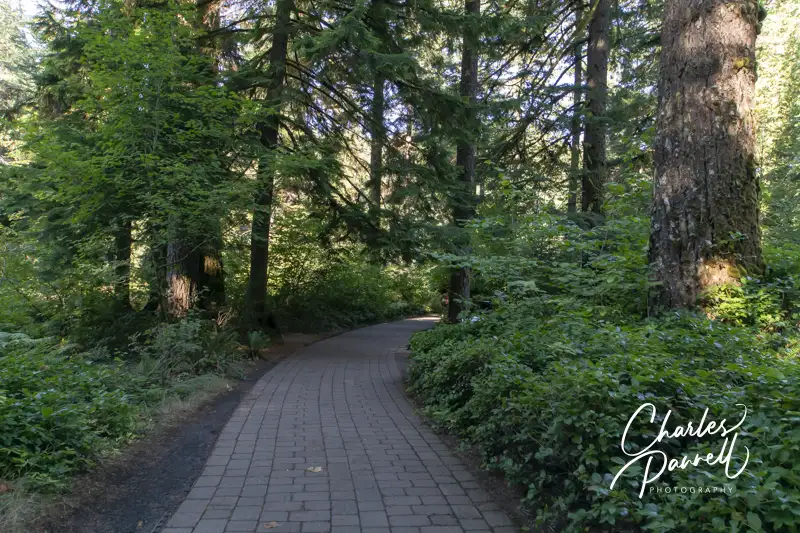
The Doetsch Area is located to the west of Beacon Rock, on the south side of Highway 14. This area has moorage sites, accessible camping, the Doetsch Trail and a nice picnic area. This is the newest area of the park, and it has the best wheelchair-access.
Finally, the group camp and the equestrian trailhead are located on the north side of Highway 14, between the Upper Campground and the Doetsch Area.
Spend the Night
The best wheelchair-accessible camping option in the park is located in the Woodard Creek Campground, near the moorage sites in the Doetsch Area. There are only two campsites there (A and B), and although both are in a level area, campsite B is the designated accessible site.
There’s accessible parking next to campsite B, which has a paved driveway, and a level site with a fire ring and picnic table. Campsite A is also doable for many folks, but it lacks a paved driveway. The accessible shower house is located across the parking lot, about 50 feet away. It includes accessible bathrooms with large stalls, grab bars, and roll-under sinks, as well as individual accessible shower rooms. There’s barrier-free access to the shower rooms, which each include a roll-in shower with a fold-down shower bench, a lowered showerhead, grab bars and a second seat for changing. It’s all very nicely done access-wise.
Additionally, there are five RV sites located in a level area near the end of the road in the Doetsch Area. That said, the sites near the moorage area are a much better choice, as they offer more privacy than the RV sites.
Unfortunately, the historic Upper Campground presents some obstacles for wheelchair-users and slow walkers. It’s a hilly campground and there are no designated accessible spaces. That said, campsites 19 and 20 are the closest sites to the bathrooms; however it’s still a uphill trek to get to them. Some slow walkers may be able to use these sites, but it’s not a realistic option for most wheelchair-users. The Woodward Creek Campground is newer, and includes modern access features.
Explore Hadley Grove
Hadley Grove
Named for the first superintendent of Beacon Rock State Park, Hadley Grove is just a short hike from the Upper Campground. This lovely slice of a second-growth fir forest is a pleasant spot to linger, especially on a hot day. And although the trail is rated as wheelchair-accessible, it’s not a flat level path.
The trail to Hadley Grove begins near campsite 11 in the Upper Campground. The designated parking area for the trail is small, and it’s covered with chunky gravel. Although the official trail description says there are two steps up to the trailhead, it’s more of a short steep pathway. After that, there are several switchbacks before you reach Hadley Grove, about 500 feet down the trail.
Accessible trails are allowed running slopes of 8% to 10% as long as there are resting intervals every 30 feet. And that pretty much describes the first part of the trail to Hadley Grove. That said, once you reach the grove, a level well-maintained trail winds through it. It’s a beautiful and peaceful spot to stop and linger, and take in the beauty of Mother Nature.
To be honest the steepest part of the trail is the slope up from the parking area, and if you can manage that, there’s a good chance the trail won’t offer any obstacles to you. That said, manual wheelchair-users will probably need some assistance on at least the first slope. Give it a try, and if it doesn’t work for you, you can always turn back.
Enjoy the Doetsch Trail
Doetsch Walking Path
In contrast to the trail to Hadley Grove, the Doetsch Trail offers excellent wheelchair-access. Located in the Doetsch Day-Use Area, there’s accessible parking and barrier-free access to the trailhead. There are also accessible restrooms near the parking area.
The 1.2-mile paved trail winds through a meadow bordered by mountains and the Columbia River. There are benches to sit and take a break along the way, and it’s an excellent birding site. About halfway along the trail, you’ll get a nice river view before the trails loops back through a shady forest to the parking area.
As an added bonus there are several accessible picnic tables in the meadow, near the parking area. So pack along a lunch and enjoy it al fresco. Not only is it a scenic spot to enjoy lunch, but it’s also the most accessible picnic area in the park. It’s a great way to top off any visit to Beacon Rock State Park.
Picnic Tables on the Doetsch Walking Path
Barrier-Free Travel Washington National Parks for Wheelers and Slow Walkers
Don’t let the “state park” moniker fool you, as this spot really is just a quick road trip stop. It makes for a good break if you are tooling along Interstate 90 in Southern Montana. Just take exit 208, then follow Highway 1 for about seven miles. You can’t miss it — just look for the small parking area right before abandoned guard shack.
There’s accessible parking in the parking lot, with level access over to the exhibits. The first installation is a metal sculpture of a miner, a smelter worker and a railroad worker, and it represents the labor that built the local copper industry. From there, a level sidewalk leads up to a viewing area where you can get a good look at the remaining smoke stack. The smoke stack is 585 feet tall — about 30 feet taller than the Washington Monument. It’s one of the tallest freestanding brick structures in the world, and it serves as a reminder of the copper smelter industry that once dominated the local economy. Today the smokestack is all that remains of that era, and that industry.
There are no facilities in the parking lot — which pretty much comprises the whole state park — but there’s a rest area near the Interstate 90 exit. The smoke stack makes a nice detour if you are getting off to use the rest area; and it’s a good vantage point to get some smoke stack photos. And it’s free.
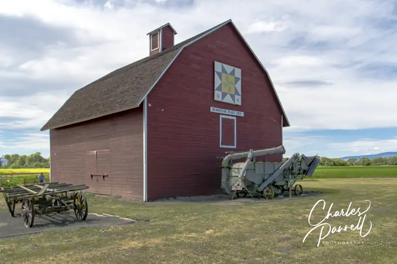
Located off Interstate 90 in Northwestern Washington, Olmstead Place State Park makes a nice road trip picnic stop. The GPS directions will take you to the old barn, but continue along Ferguson Road to the next driveway for the picnic area. There’s no striping in the small paved lot, but that’s OK because you’ll most likely have it to yourself. There are accessible vault toilets in the parking area, and a level gravel path leads over to several picnic tables on the grass. They aren’t any accessible tables, but there’s room at the end for wheelchairs. There’s a little freeway noise, but it’s a nice departure from the rest area picnic tables. And it’s not crowded.
After lunch feel free to browse around the old homestead. The site is level and there are some gravel pathways but you’ll have to roll over the grass to get to a number of the buildings. There are a lot of farm out buildings as well as the old homestead to peruse. The barn area is also worth a look, and if you can’t manage the pathway, then it’s a short easy roll down Ferguson to get to it. There’s not much traffic on Ferguson, so it’s pretty safe. There’s a sizable display of farm implements next to the barn, and a decorative quilt square adorns the front. It’s a nice picnic spot, and a great place to dodge the crowds.
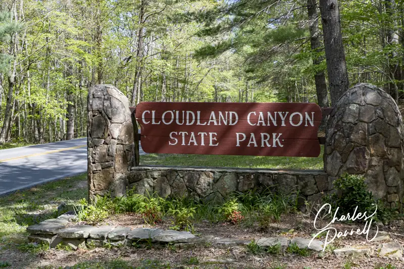
Located on the western edge of Lookout Mountain in far Northwestern Georgia, Cloudland Canyon State Park (gastateparks.org/CloudlandCanyon) boasts some of the best views in the state. Visitors marvel at the deep gorge cut by Daniel Creek, and enjoy sandstone cliffs, dense woodlands and abundant wildlife in this remote natural area. But remote doesn’t necessarily mean inaccessible, as slow walkers and wheelchair-users can also enjoy the scenery and then bed down in an accessible yurt at this off-the-beaten-path scenic find.
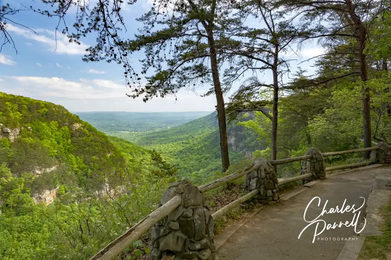
Enjoy the Canyon View
Overlook Trail in Cloudland Canyon State Park, Georgia
Although a good chunk of Cloudland Canyon State Park is composed of rugged backcountry and some challenging trails, the most spectacular canyon views can be found on the accessible Overlook Trail. Accessible parking is available in the picnic area parking lot, with level access over to the trailhead. There are also accessible picnic tables and restrooms near the parking area.
Make a right at the trailhead to take the Overlook Trail, as a left turn will put you on the inaccessible West Rim Loop Trail, which descends into the canyon. The Overlook Trail is wide and paved and mostly level, and is marked by light blue blazes on the trees. This half-mile trail winds along the canyon and offers some nice views along the way.
The most accessible overlook is located directly behind the interpretive center. Some manual wheelchair-users may require assistance with the slight grade, but it’s quite doable for most power wheelchair-users. There are also two more overlooks along the trail, but due to some aging Civilian Conservation Corps stone steps, they are not accessible.
After the second overlook the trail winds through the forest past a picnic table before it loses its access. Still it’s a pleasant one-mile round trip hike, with benches to sit and enjoy the forest along the way. And if you can’t manage the distance, at least stop for the beautiful canyon view behind the interpretive center.
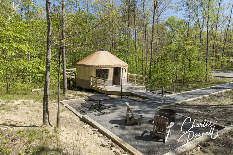
Camp Out in an Accessible Yurt
Yurt 10 in Cloudland Canyon State Park, Georgia
If you’d like to spend the night at Cloudland Canyon State Park, then reserve a comfortable yurt. Yurt 10 is wheelchair accessible and can sleep up to six people. Accessible parking is available near the yurt, with a drop-off space directly in front of the level walkway to the front porch.
The yurt features wide doorways and wood floors and is outfitted with a 13-inch high bunk bed (bottom bunk) and a 19-inch high double futon. Other furnishings include four bar stools, a tall table, a shorter wheelchair-height table and some shelves. The yurt is also equipped with electric outlets, a ceiling fan and a heater. Linens are not provided, so make sure to pack along your sleeping bag.
There’s level access out to the private back porch that’s surrounded by the forest, and furnished with two Adirondack chairs and a small table. Out front there’s an accessible picnic table on a pad, a grill, a deer dressing stand and a water spigot. It’s a comfortable set up, and with only 10 yurts in the village, it’s not as crowded as the campgrounds.
The comfort station is located a short walk down a paved road; however there’s also an accessible parking space in front if you’d prefer to drive. The standard comfort station is not accessible, but there are two large accessible family restrooms next door. They each feature a toilet with grab bars, a roll-under sink and a full five-foot turning radius. The shower area includes a roll-in shower with grab bars, a fold-down shower bench and a hand-held shower head. And since these two units are mirror images, there’s a choice in regards to toilet grab bar placement.


")
