As a travel writer since 1977, Candy Harrington has been writing about accessible travel exclusively since 1996. She’s the founding editor of Emerging Horizons, and the author of the popular Barrier-Free Travel national park series. With thousands of bylines to her credit, Candy hits the road often, in search of new accessible travel finds. Candy and her travel photographer husband Charles Pannell reside in NE Washington, where they tend to their chicken flock and enjoy a rural lifestyle.
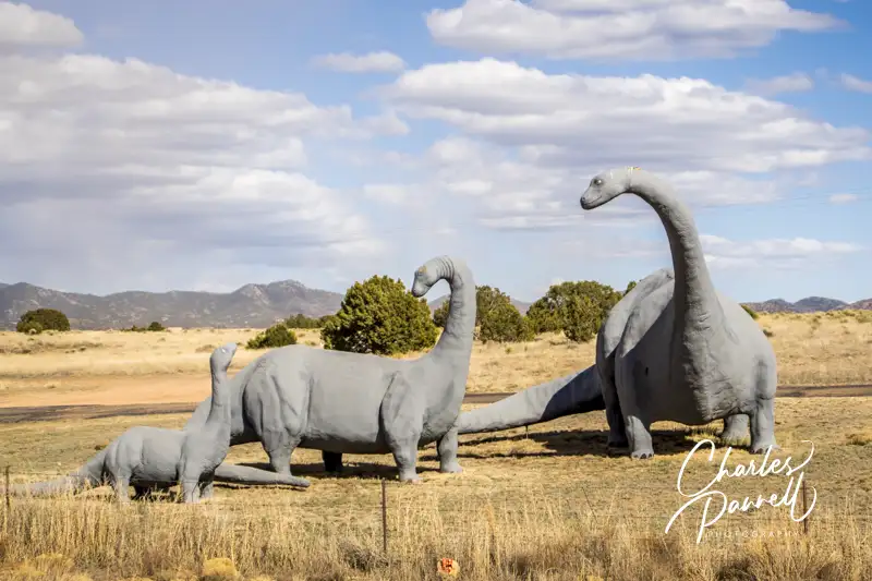
This life-size Brontosaurus Family can be found just outside of Santa Fe, New Mexico. Believed to be the work of the late Larry Wilson who made a name for himself by crafting dinosaurs out of polyurethane foam, this out-of-the-way roadside attraction is a bit tricky to find, but well worth the effort.
From Interstate 25, take exit 278, then go south on Highway 14. Turn left at the first light (Rancho Viejo Boulevard), then go left at the Bureau of Land Management sign on Dinosaur Way. The family is located about a mile down the road on the right, next to a green metal building at M&M Garage Door & Gates. The sculptures are located on private property but there is a level grassy pullout along the road where you can get a good look at them. There’s no accessible parking or pathway to the sculptures, but truly there’s a great windshield view from the pullout. As an added bonus, there’s also a T-rex busting out of the adjacent metal building, which made the news in 2001, when the sculptor put an Osama bin Laden dummy in its jaw. This roadside attraction is just a short detour off the highway, and a definite must-see on the drive between Albuquerque and Santa Fe.
Located on an original stretch of Route 66, this combination gas station and souvenir shop is definitely a blast from the past. Take some time to explore the vintage cars, signs, tools and assorted junk outside, before you catch a glimpse of the vintage pinups in the men’s restroom inside at the Hackberry General Store. There’s plenty of room to park an adapted van in the dirt parking area, and there’s a level entry to the souvenir shop. And although there are a few steps inside, you can still get a good feel for this vintage attraction without navigating them. A must-stop on any Route 66 road trip! (emerginghorizons.com/wheelchair-accessible-route-66-a-great-grand-canyon-side-trip/)
Barrier-Free Travel the Grand Canyon for Wheelers and Slow Walkers
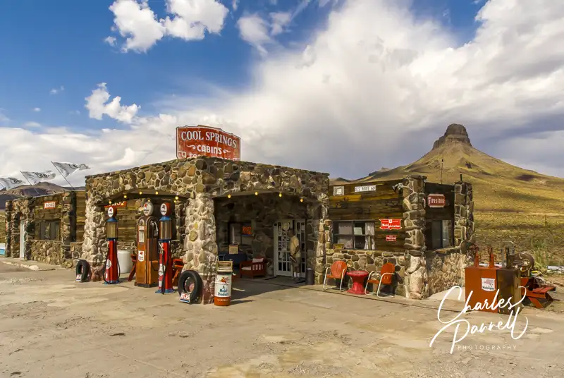
Cool Springs General Store
8275. W. Oatman Road
Golden Valley, AZ
Located west of Kingman, along an original patch of Route 66, Cool Springs General Store was a welcome sight to road weary travelers back in the day. Hollywood also discovered it in 1992, when it was used as a filming location for Jean-Claude Van Damme’s Universal Soldier. Sadly it was demolished in the final scenes of the movie; however it was later sold and rebuilt to resemble the original 1926 incarnation.
Today it’s worth a stop on any Route 66 road trip. Parking is available in a level dirt area, with barrier-free access to the main entrance of the gift shop and museum. And even though there is one step inside, there’s also access to the raised area of the building from a second accessible entrance.
The makeshift museum offers up a quirky collection of found objects that includes everything from an old gas pump and tools, to oil cans, photos, toys and even vintage post cards. There’s also a t-shirt shop, jewelry counter and a decent selection of Route 66 souvenirs peppered around the memorabilia. Outside, there’s an old 1935 rusted out Nash Sedan to the left of the store. And of course the old gas pump, which rests under a restored stone canopy.
Barrier-Free Travel the Grand Canyon for Wheelers and Slow Walkers
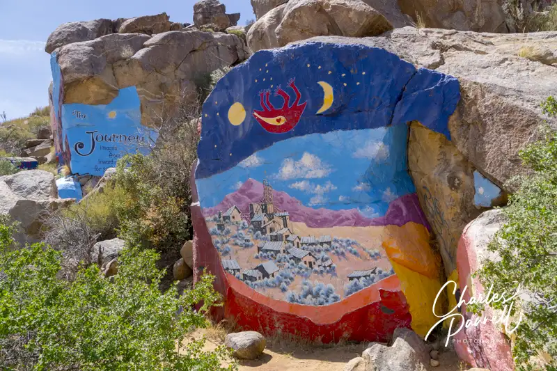
Located off of Highway 93 about 25 miles north of Kingman, the Chloride Murals are a must-see on the way to Las Vegas or Grand Canyon West. Just take Road 125 (exit 53) and head east for four miles to reach the town proper. The murals are actually located on the other side of town in the hills. Continue along the main drag (Tennessee Avenue), cross a second cattle guard and then follow the dirt road 1.4 miles up to the murals.
A word of warning about the road — it’s not doable in a low-clearance vehicle, and there’s certainly ample evidence of oil pan damage along the route. A four-wheel-drive vehicle is not required though, and most SUVs and trucks will manage quite nicely. And once you arrive at the murals, there’s a wide level spot to park right next to the art work.
Artist Roy Purcell painted the boulder murals in the mid 60s, and the vibrant colors have definitely stood the test of time. Titled “The Journey” the murals include images of a snake eating the sun, a talon grabbing at Chloride, fertility images, pieces with a definite Yin and Yang side, astrological signs and many scenes that are open to interpretation. Take some time to study the murals, as the longer you look at them, the more hidden details you’ll spot.
Barrier-Free Travel California National Park Road Trips for Wheelchair-Users and Slow Walkers
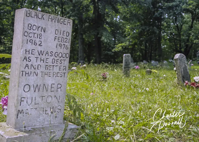
Established in 1937 when Key Underwood laid his dog Troop to rest at his favorite hunting camp, the Key Underwood Coon Dog Memorial Graveyard now has more than 185 hounds buried there. It’s located in Northern Alabama about 30 miles from Tuscumbia, just 13 miles south of US Highway 72.
There is a small gravel parking area, and the terrain is fairly level and in dry weather it’s doable for most wheelers and slow walkers. You’ll see a little bit of everything at the graveyard, from marble monuments and wooden headstones to dog collars and even a plastic raccoon grave marker.
It’s still an active cemetery, as true coon dogs are eligible to be buried there. And they do stick to those restrictions. As the former caretaker elaborated, “A dog can’t run no deer, possum — nothing like that. He’s got to be a straight coon dog, and he’s got to be full hound. Couldn’t be a mixed up breed dog, a house dog.” All in all it’s a fun stop, and some of the headstones and memorials are priceless.
Barrier-Free Travel 22 Accessible Road Trips for Wheelers and Slow Walkers
Ronald A. Olson Island Bridge at Tahquamenon Falls State Park
There’s good news for wheelchair-users and slow walkers in Michigan — loaner track chairs are now available at many state park and recreation areas. Track chairs allow people with reduced mobility the freedom to explore places that are otherwise inaccessible to them. These off road wheelchairs have tank tracks instead of wheels, and can easily navigate over sand, rough surfaces and even snow. They also come with a big price tag; but thanks to a massive fundraising effort, loaner track chairs are now available at many Michigan outdoor spaces
The following organizations were instrumental in making these Michigan track chairs a reality.
Grand Haven Area Community Foundation (ghacf.org/)
Where to find Michigan Track Chairs
The loaner track chairs are available at the following Michigan state parks and recreation areas. Each venue has different rules, regulations and hours, so check in advance to avoid disappointment. And keep in mind that some locations also require reservations to borrow the track chairs.
Bald Mountain Recreation Area
Bay City State Park
Brighton Recreation Area
Grand Haven State Park
Harrisville State Park
Hartwick Pines State Park
Lake Hudson Recreation Area
Leelanau State Park
Petosky State Park
Wilson State Park
Holland State Park
Ionia Recreation Area
Island Lake Recreation Area
Ludington State Park
Maybury State Park
Muskegon Recreation Area
North Higgins Lake State Park
Tahquamenon Falls State Park
Warren Dunes State Park
Waterloo Recreation Area
Wilderness State Park
If you didn’t find your favorite Michigan state park or recreation area on the list, don’t worry as this popular program is constantly expanding. New venues for loaner Michigan track chairs are being added as funding becomes available. Visit www.michigan.gov/dnr/about/accessibility/track-chairs to check for the latest additions.
‘
Barrier-Free Travel Glacier, Yellowstone and Grand Teton National Parks for Wheelchair-Users and Slow Walkers
Population 177
Last but certainly not least, Midpines makes a great stop on a Yosemite road trip — plus it’s the perfect home base for day trips to the park. And there are not one, but two wheelchair-accessible properties in town. The Yosemite Bug (www.yosemitebug.com) tops the list, as this rustic mountain resort offers a wheelchair-accessible room that’s furnished with two queen beds and has a bathroom with a roll-in shower.
And if you’d like to try something different, AutoCamp Yosemite (https://autocamp.com/location/yosemite/) offers several accessible glamping options. Their custom built wheelchair-accessible X Suite is reminiscent of an upscale RV. It’s furnished with a small galley, and includes a queen-sized bed and a bathroom with a roll-in shower. Alternatively they also have two accessible Classic Suites and an fully furnished accessible glamping tent. And the YARTS (yarts.com) shuttle stops at the Yosemite Bug in Midpines, which allows folks to sit back and enjoy the ride to the park, and skip the sometimes long entrance lines.
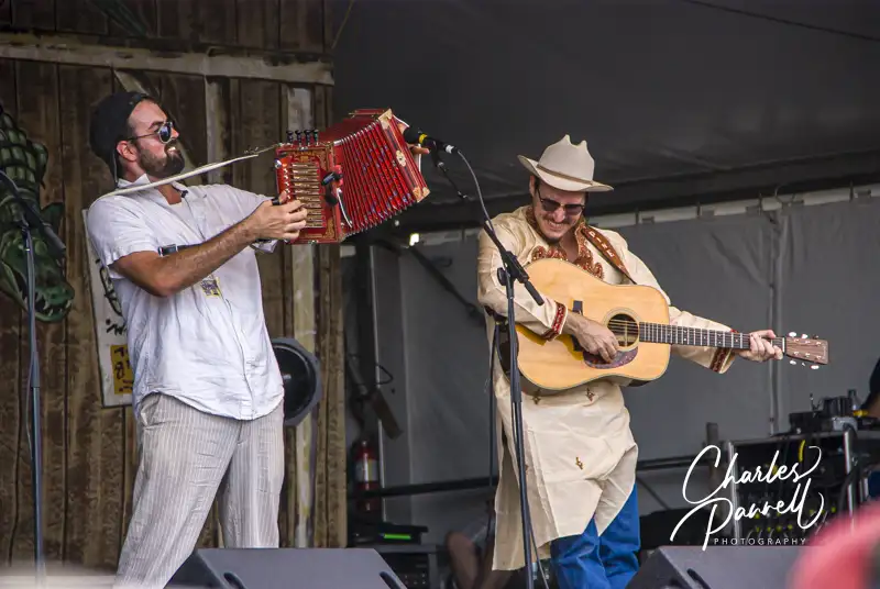
The Pine Leaf Boys perform at the New Orleans Jazz Fest
The 2025 New Orleans Jazz Fest is scheduled to run from April 24 to May 4, 2025. Live music will be presented on April 24-27 and May 1-4 at the Fair Grounds Race Course, which is located about 10 minutes from the French Quarter. This massive venue features multiple stages that offer continuous music from 11 a.m. to 7 p.m. And the good news is, wheelchair access at the New Orleans Jazz Fest has not been overlooked.
Music at the festival ranges from jazz, blues and zydeco to folk, rock and rap. There’s even a kid’s tent for the little ones. And as more musicians stream into New Orleans, you’ll find more street performers in the French Quarter. In short, everywhere you look there’s music.
There’s also a large variety of food vendors at Jazz Fest, who feature everything from crawfish and alligator to vegetarian plates and even the standard burgers and brews. And don’t miss the crafts area, where artisans from around the world demonstrate and sell their wares.
For more information about the complete entertainment lineup or to buy tickets for this years Jazz Fest, visit www.nojazzfest.com. And for information on specific access features at this annual event, check out the information below.
Getting There
At the top of the list for wheelchair access at the New Orleans Jazz Fest is getting there. Accessible parking is available near the main gate on Gentilly Boulevard. There is a $50 per day fee for parking on Thursdays and Fridays, and a $65 fee on Saturdays for these limited accessible spaces. They are only available to folks with a valid accessible placard or plates, and the person who owns the plates or placard must be in the vehicle. These accessible spaces are available on a first-come basis, and credit cards are the only accepted method of payment.
If you’d prefer to let someone else do the driving, then buy a ticket on the Jazz Fest Express (www.graylineneworleans.com/jazz-fest-express/), which is operated by Gray Line Tours. The buses run continuously from the Sheraton Hotel on Canal Street, the Wisner Boulevard parking lot at City Park (5700 Wisner Boulevard) and the Steamboat Natchez Wharf in the French Quarter. They drop passengers off at the main gate on Gentilly Boulevard, which is the accessible entrance. Not all of the buses are lift-equipped, so call (504) 569-1401 or (800) 233-2628 to make advance arrangements if you need accessible transportation.
Accessible public transportation to the Jazz Fest is also available on RTA buses (www.norta.com/ride-with-us/know-before-you-go/transit-accessibility)
and on the red streetcar line. Alternatively, you may be able to arrange for accessible transportation through RTA ADA Office (504-827-8345); however advance reservations are a must and the demand is usually quite high during Jazz Fest. This option is only available if you are unable to ride public transportation due to a disability. A valid paratransit card is also required.
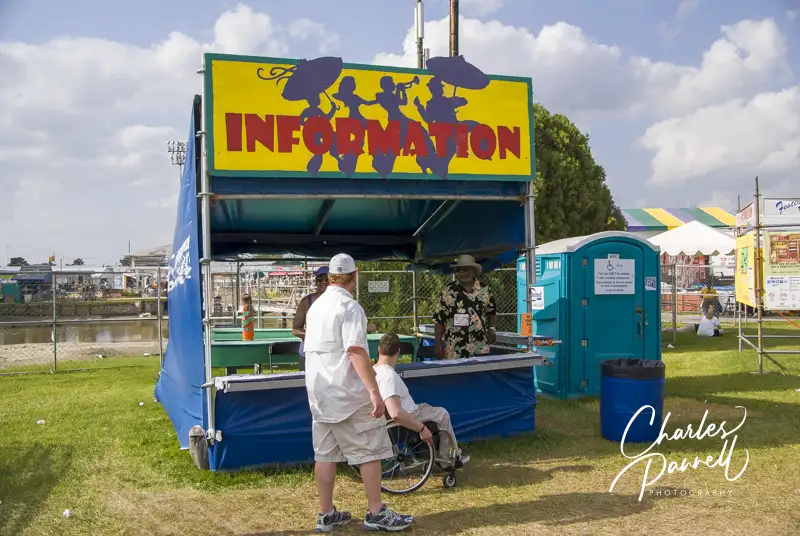
Jazz Fest Access Center
Jazz Fest Access Center
The Jazz Fest Access Center is also an integral part of wheelchair access at the New Orleans Jazz Fest. It’s conveniently located in front of the grandstand. That’s where you can pick up an access map of the grounds, which includes the accessible routes, viewing areas and the locations of the accessible porta-potties (www.nojazzfest.com/downloads/2024-Access-Map.pdf). The combinations to the accessible porta-potties are also available there.
The festival grounds are comprised of a variety of surfaces, including grass fields, a dirt track and paved pathways in the infield. Reinforced surfaces are also installed across the dirt track to increase accessibility. The accessible routes are clearly marked, so be on the lookout for these signs. And don’t hesitate to ask the folks in the Access Center if you need any assistance.
The Paralyzed Veterans of America booth is located next to the Access Center. They can provide loaner wheelchairs to folks who can’t manage distances. There’s no charge for the wheelchairs, but donations are always appreciated.
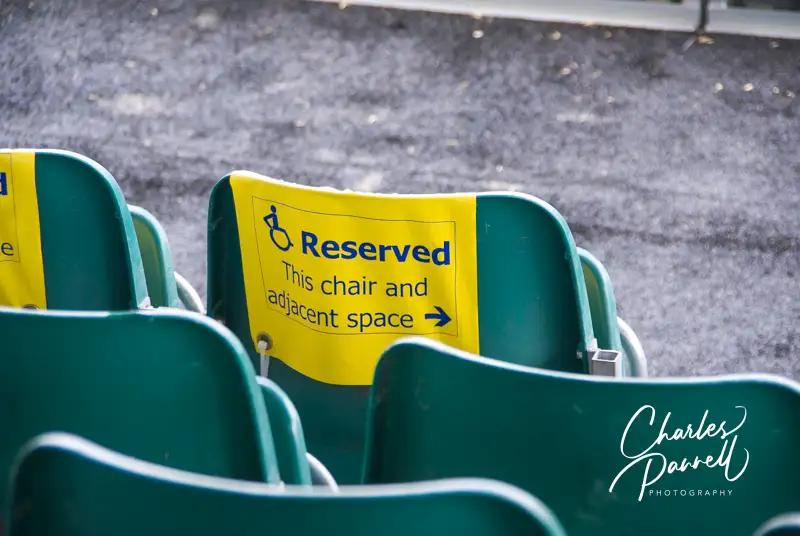
Wheelchair-Accessible Seating
Wheelchair Seating at the New Orleans Jazz Fest
The final component of wheelchair access at the New Orleans Jazz Fest is accessible seating, which is available at all the Jazz Fest music venues. General seating for the main stages is located on the lawn area. Concert-goers either bring their own folding chairs, or spread blankets out on the ground.
Accessible seating and parking is also available in the VIP packages (https://www.nojazzfest.com/tickets/), which must be purchased in advance.
Accessible seating for the main stages is limited to wheelchair-users and one companion. To be admitted to the accessible seating section, you must have a wristband, which can be obtained at the Access Center.
Accessible seating for wheelchair-users and one companion is also available at all the tent stages and the grandstand stages. And if you need a break from the heat, keep in mind that the grandstand stages also have air conditioning.
It should also be noted that the accessible seating is designated for patrons who use a wheelchair or scooter, and not those with limited mobility, a temporary injury or who are pregnant. The accessible seating rules are enforced, so that people who need these accommodations will have access to them. If a person does not meet the eligibility requirements, they will be removed from the accessible seating area.
Bottom line — access rocks at Jazz Fest. And so does the Jazz Fest staff and volunteers. If you have any access related questions, just e-mail access@nojazzfest.com or call (504) 224-9767.
Barrier-Free Travel 22 Accessible Road Trips for Wheelers and Slow Walkers
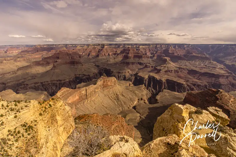
View from Hermit Road In Grand Canyon National Park
Although US National Parks have done a great job with providing inclusive access for disabled visitors, sometimes alternative — but equal — policies have been established. Such is the case with the issue of private vehicle usage is some national parks. For example, some parks limit vehicle access to certain areas in order to control crowds or minimize the environmental impact on fragile ecosystems. In many cases wheelchair-accessible shuttle bus access to these areas is the solution.
But what if your scooter is too big for the accessible shuttle bus, or if you have to tote along a lot of medical equipment? Well in these cases — and many more — alternate access is available to disabled individuals in the form of special driving passes for disabled national park visitors. Check out what these three national parks offer, and find out how to secure a driving pass for your next visit.
Zion National Park
In order to manage traffic in Zion Canyon, only shuttle bus traffic is allowed on Zion Canyon Scenic Drive between March and November, and during the December holiday season. People who have reservations at Zion Lodge are allowed to drive to the lodge and park in the parking lot, with a Red Pass permit and a parking code, which are provided when the reservation is made.
Visitors who need to carry along additional medical equipment or folks who cannot ride the shuttle because of a medical condition are eligible for a Yellow Pass permit to drive their personal vehicles along the entire length of the Zion Canyon Scenic Drive. Visitors who cannot ride the shuttle due to weight or size restrictions are also eligible for this permit. The shuttle lift can accommodate a combined weight limit of 600 pounds, and wheelchairs that are up to 45 inches long and 25 inches wide. The free Yellow Pass permits are available at the information desk at the Zion Canyon Visitor Center.
Grand Canyon National Park
In Grand Canyon National Park, Hermit Road and Yaki Point Road have restrictions on private vehicle usage. Hermit Road is closed to private vehicles from March 1 to November 30; and Yaki Point Road and the Kaibab Trailhead parking lot are closed to private vehicles all year. A free park shuttle is used to transport people to these areas of the park.
A special Scenic Drive Accessibility Permit is available to anybody who has mobility issues, and may have problems boarding the park shuttle buses. All shuttle buses are lift-equipped and can accommodate wheelchairs up to 48 inches long and 30 inches wide. Most motorized scooters will not fit on the buses.
There is no fee for the permit, which is available at park entrances and visitor centers. An accessible parking placard or disabled license plates are required to park in accessible parking spaces in the park, as the Scenic Drive Accessibility Permit is not good for that purpose.
Yosemite National Park
Although Yosemite doesn’t require special driving passes for disabled national park visitors, a few areas of the park where vehicles are restricted are open to visitors that have an accessible parking placard or disabled license plates. These roads include the Happy Isles Loop Road, the Mirror Lake Road and the access road to the Grizzly Giant in Mariposa Grove. The speed limit on these roads is 15 mph, and drivers must use their hazard lights when driving. It should be noted that these roads are open to bicycles and pedestrians, so keep an eye out for them.
Additionally, visitors with a temporary disability or folks who forget their parking placards can obtain a temporary disability placard at the park. This placard allows visitors to park in accessible parking places in the park, as well as drive along Happy Isles Loop Road, the Mirror Lake Road and the access road to the Grizzly Giant in Mariposa Grove. The temporary disability placard is available at park entrance stations or visitor centers.
Barrier-Free Travel the Grand Canyon for Wheelers and Slow Walkers
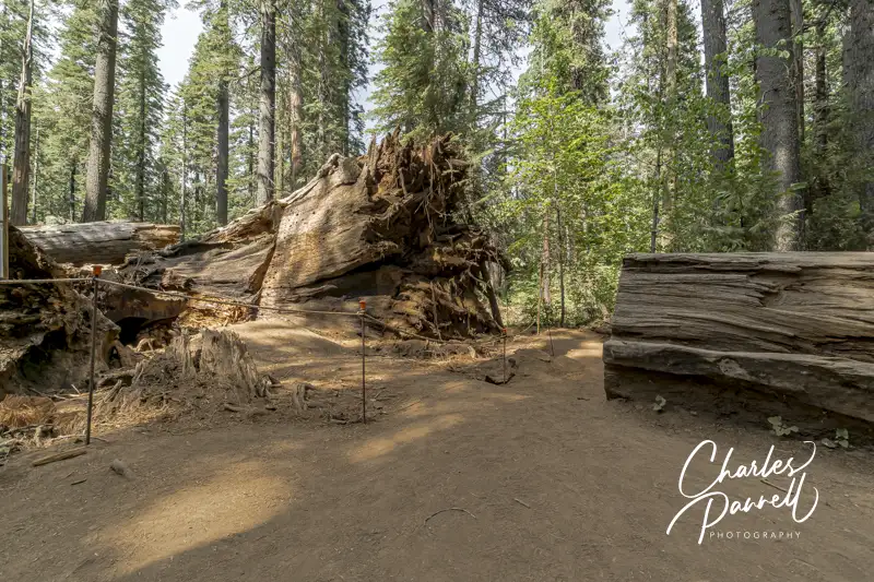
The fallen Pioneer Cabin Tunnel Tree in Calaveras Big Trees State Park
Make no mistake about it, California can have some brutal winters. Take 2017, for example. Between a record rainfall, mudslides and a late season snow it was definitely a challenge for many mountain communities. And unfortunately there were a few causalities, such as the loss of the Pioneer Cabin “tunnel tree” at Calaveras Big Trees State Park (www.parks.ca.gov/?page_id=551).
Sadly this giant sequoia was uprooted during a torrential downpour; however after a massive spring cleanup the grove reopened, with traffic routed around the fallen giant. Today the forest has evolved, however this Northern California state park is still worth a visit for a very accessible and intimate look at the remaining giant sequoias. And for a nice wheelchair-accessible place to spend the night, check out the nearby Black Bear Inn (emerginghorizons.com/sleep-near-the-big-trees-in-calaveras-county/) in Arnold.
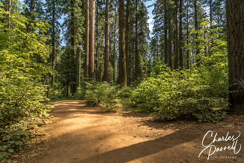
The Majestic North Grove
North Grove Trail in Calaveras Big Trees State Park
Although the giant trees are scattered through the park, the North Grove has the most accessible concentration of them. Accessible parking is located near the visitor center, which offers barrier-free access and features a collection of interpretive exhibits. Accessible restrooms with flush toilets are located next to the visitor center.
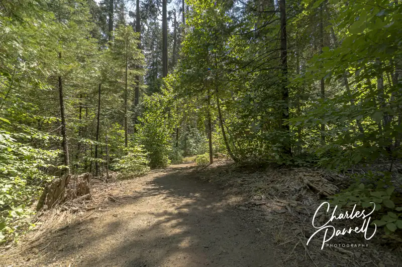
The trail to the North Grove begins to the left of the visitor center. This hard-packed dirt tail winds around to the right to the Discovery Stump, the official beginning of the grove. This was the site of the first tree that Augustus T. Dowd found in 1852, while he was chasing a wounded grizzly bear. Sadly the tree was felled in 1853, but remnants of it can be found next to the stump.
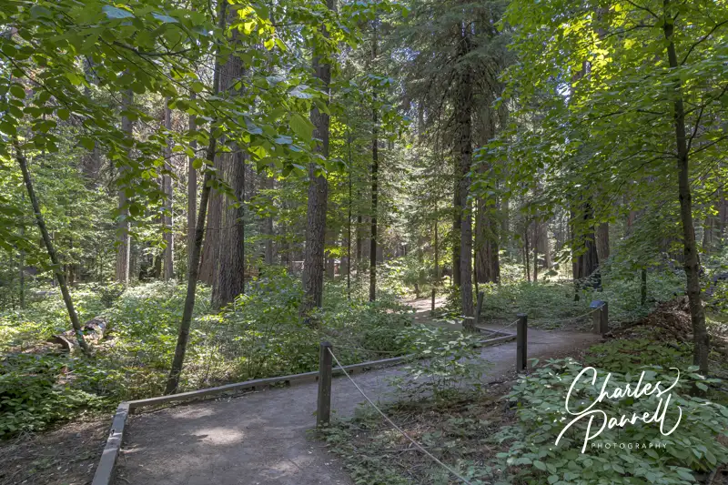
The Three Senses Trail — which is located just past the Discovery Stump on the left — is also worth a stop. This .13-mile hard-packed dirt trail features interpretive plaques about the native vegetation, and includes benches to sit and rest along the way. And although the trail has a few bumps here and there, it’s still a good choice for most wheelchair-users and slow walkers.
Three Senses Trail in Calaveras Big Trees State Park
The hard-packed dirt North Grove Trail, continues past the Three Senses Trail, and winds around the Empire Tree, the Old Bachelor, the Mother-of-the-Forest and the Father-of-the-Forest. At times the dirt transitions to a level boardwalk, as this 1.7-mile trail snakes past the named and unnamed giants.
Just past the Abraham Lincoln Tree, there’s a detour around a fallen giant and through the remains of the Pioneer Cabin Tree. The fallen tree will remain on the ground to provide nourishment to new trees, and continue the forest cycle. And although the North Grove is accessible, it’s best to visit after the winter debris has been cleared in the early summer.
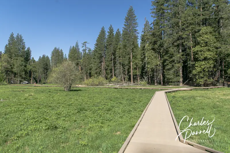
A Meadow Boardwalk
Meadow Boardwalk in Calaveras Big Trees State Park
Although the major focus is on the giant sequoias at Calaveras Big Trees, there’s also a nice accessible boardwalk through a meadow near the North Grove. The meadow itself is surrounded by the North Campground, which is just a short level walk from the visitor center. Follow the park road to the North Grove Campground, and if you hit the dump station, go back as you missed the campground.
Stay on the main campground road, and be on the lookout for accessible campsite 16 on the left. There’s an accessible showerhouse right behind the campsite, and the meadow boardwalk begins on the far side of that building.
There’s level access to this short boardwalk. It’s only .3-mile long, but when the wildflowers are in bloom it’s a sight to see. Lupine and corn lilies fill the meadow in June and July; although peak bloom time is weather dependent. And be on the lookout for Western Tanagers which also frequent the meadow. The boardwalk had low bumpers and no railings so wheelchair-users get an unobstructed view of all of natures beauty. And don’t forget to check at the visitor center to see if there are any wildflower walks scheduled.
The Quieter South Grove
Save some time to explore the South Grove at Calaveras Big Trees. Here you’ll find fewer visitors and the nicely accessible Beaver Creek Trail. It’s easy to find, as it’s near the end of the Walter W. Smith Memorial Parkway, about twenty minutes from the entrance station.
Accessible parking is located near the accessible vault toilet, and there’s level access over to several accessible picnic tables shaded by the surrounding forest. The .7-mile Beaver Creek Trail begins behind the vault toilet. This hard-packed dirt trail follows Beaver Creek, then passes the South Grove parking area, before it loops back to the Beaver Creek picnic area.
Make sure and stop at Beaver Creek along the trail, which is just .1 mile from the Beaver Creek picnic area. Not only are there some more picnic tables near the creek, but beach mats allow for access right up to the water.
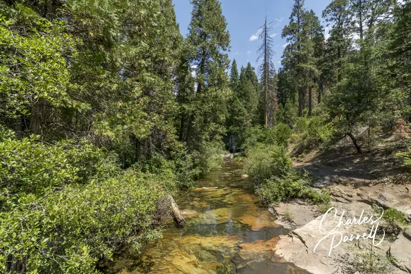
Beaver Creek viewed from the Beaver Creek Trail in Calaveras Big Trees State Park
If you want to try a more challenging — yet still accessible — trail, then head on over to the River Picnic Area and try the Stanislaus River Trail. The trailhead for this .35-mile round-trip hike on a hard-packed dirt trail is is next to the parking area. The trail winds downhill to the river, however it still maintains an accessible grade. Make sure and take a good look at the trail in the beginning though, as it’s not flat, and you will have to make your way back up to the parking area.
Stanislaus River Trail in Calaveras Big Trees State Park
You’ll get a nice gander of the river from the end of the trail. It’s also pretty secluded and not frequented by a lot of park visitors. Granted this trail won’t work for everyone, but if you fancy a little workout it’s just what the doctor ordered.
Barrier-Free Travel California National Park Road Trips for Wheelchair-Users and Slow Walkers
 246 Dinosaur Trail
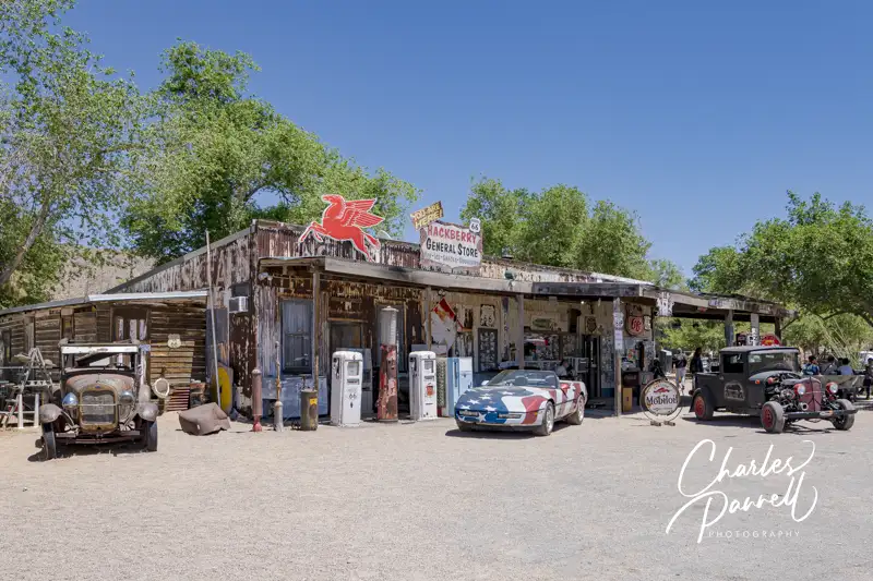


 (Uploads), CC0, via Wikimedia Commons")