Don’t let the “state park” moniker fool you, as this spot really is just a quick road trip stop. It makes for a good break if you are tooling along Interstate 90 in Southern Montana. Just take exit 208, then follow Highway 1 for about seven miles. You can’t miss it — just look for the small parking area right before abandoned guard shack.
There’s accessible parking in the parking lot, with level access over to the exhibits. The first installation is a metal sculpture of a miner, a smelter worker and a railroad worker, and it represents the labor that built the local copper industry. From there, a level sidewalk leads up to a viewing area where you can get a good look at the remaining smoke stack. The smoke stack is 585 feet tall — about 30 feet taller than the Washington Monument. It’s one of the tallest freestanding brick structures in the world, and it serves as a reminder of the copper smelter industry that once dominated the local economy. Today the smokestack is all that remains of that era, and that industry.
There are no facilities in the parking lot — which pretty much comprises the whole state park — but there’s a rest area near the Interstate 90 exit. The smoke stack makes a nice detour if you are getting off to use the rest area; and it’s a good vantage point to get some smoke stack photos. And it’s free.
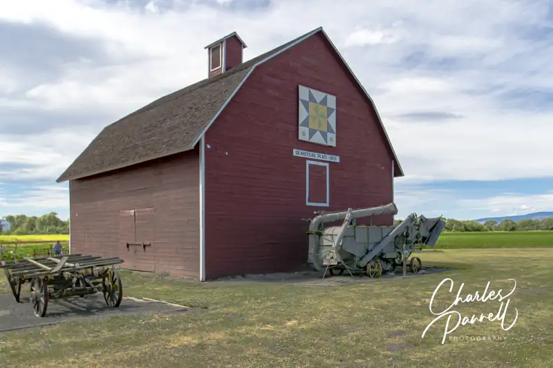
Located off Interstate 90 in Northwestern Washington, Olmstead Place State Park makes a nice road trip picnic stop. The GPS directions will take you to the old barn, but continue along Ferguson Road to the next driveway for the picnic area. There’s no striping in the small paved lot, but that’s OK because you’ll most likely have it to yourself. There are accessible vault toilets in the parking area, and a level gravel path leads over to several picnic tables on the grass. They aren’t any accessible tables, but there’s room at the end for wheelchairs. There’s a little freeway noise, but it’s a nice departure from the rest area picnic tables. And it’s not crowded.
After lunch feel free to browse around the old homestead. The site is level and there are some gravel pathways but you’ll have to roll over the grass to get to a number of the buildings. There are a lot of farm out buildings as well as the old homestead to peruse. The barn area is also worth a look, and if you can’t manage the pathway, then it’s a short easy roll down Ferguson to get to it. There’s not much traffic on Ferguson, so it’s pretty safe. There’s a sizable display of farm implements next to the barn, and a decorative quilt square adorns the front. It’s a nice picnic spot, and a great place to dodge the crowds.
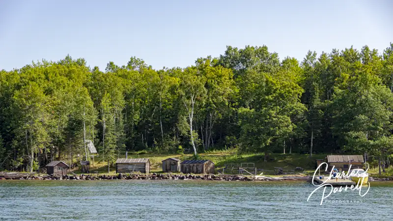
Located in Lake Superior, just off the Bayfield Peninsula, Apostle Islands National Lakeshore (www.nps.gov/apis/) is composed of 21 islands. Early settlers only found 12 of the islands though, so they named the site for the 12 apostles. The only way to explore the lakeshore is by boat – your own or a tour boat – and although there are a number of choices, Apostle Islands Cruises (www.apostleisland.com) is the best wheelchair-accessible Apostle Islands cruise option.
Anchors Aweigh
Based in Bayfield, Wisconsin, Apostle Islands Cruises offers several tours, including the comprehensive Grand Tour. This 55 mile scenic cruise departs from the Bayfield City Dock, aboard the accessible catamaran, Archipelago.
Accessible parking is available on Front Street near Rittenhouse, in front of the Keeper of the Light Gift Shop. There’s ramp access to the Apostle Islands Cruises ticket office, which is located on the corner of Front and Rittenhouse. From there it’s a short level walk out to the dock; however a loaner wheelchair is available for folks who can’t manage the distance.
There is level access to the Archipelago, and wheelchair-users and slow walkers are preboarded upon request (just ask at the ticket office). There’s plenty of room to maneuver a wheelchair around the spacious main deck, which is lined with large windows for panoramic views. There’s also a head on the the main deck that may work for some slow walkers. It has a two-inch coaming and a 28-inch wide doorway, and it’s equipped with one grab bar. On the plus side, the cruise is only 2.5 hours long so it’s easy to plan ahead if this setup won’t work for you.
Best bet is to buy your tickets online, as this is a popular summer tour. That said, feel free to call Apostle Islands Cruises if you have any access related questions or concerns (800-323-7619), as the staff is quite helpful.
The Wheelchair-Accessible Apostle Islands Cruise
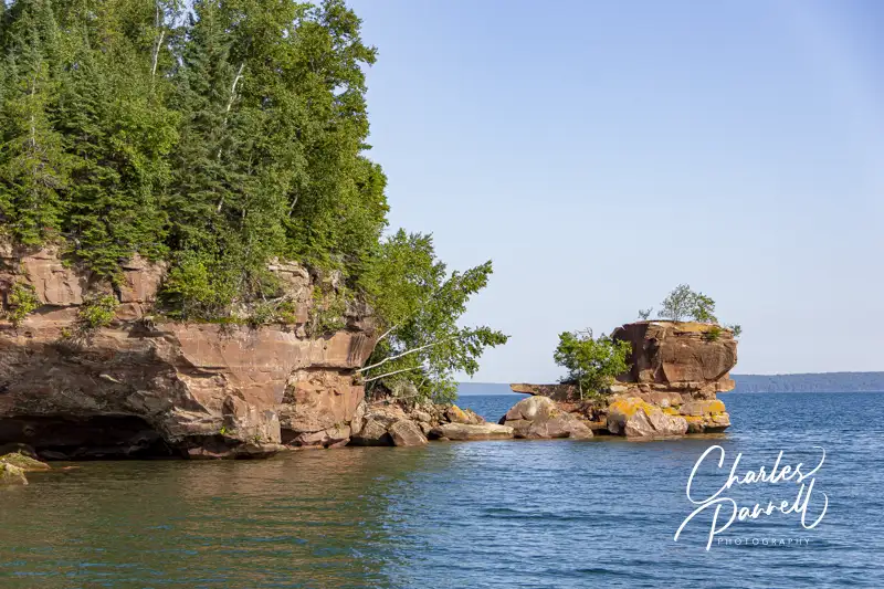
The wheelchair-accessible Apostle Islands Grand Tour features a good overview of the history and natural features of the area, and includes an on-board guide. From the harbor the cruise heads past Basswood Island, which is know for it’s “sea stack” rock formation on the north shore. After that the cruise continues north past the sandstone carved formations on Hermit Island and then passes the tallest of the Apostle Islands — Oak Island.
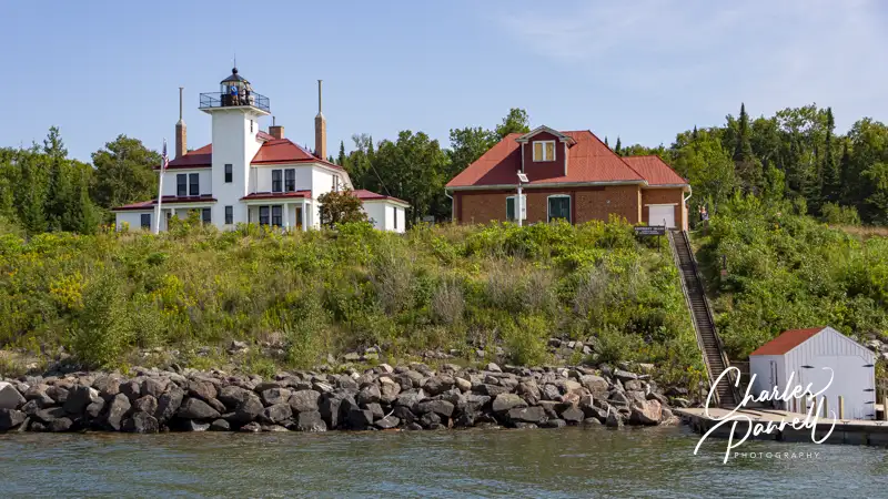
Raspberry Island in Apostle Islands National Lakeshore
Next the captain pulls in to give passengers a close look at the Raspberry Island Lighthouse. Built in 1862 this duplex building features the light tower in the middle with living quarters on both sides. The lighthouse keeper lived in one side, while the assistant lighthouse keeper lived in the other.
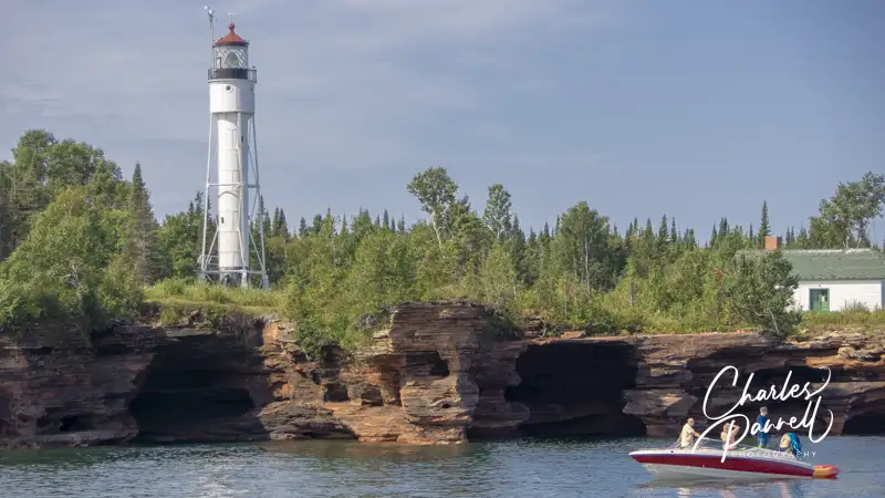
Devil’s Island in Apostle Islands National Lakeshore
After that the cruise continues north past Bear Island before it circles Devils Island for a look at another lighthouse and the rocky southern shore. Native Americans believed the island was haunted — hence the name — because the waves that crashed against the rocks sounded like a woman screaming. Today the shore is a popular spot for sea kayakers. The highlight of the island — Devils Island Light Tower — dates back to 1898, and it’s still in service today.
Finally, the cruise heads south past the fish camp on Manitou Island, then skirts Stockton Island, before it returns to the Bayfield City Dock. It’s a pleasant and educational cruise, and a nice accessible way for wheelchair-users and slow walkers to explore this remote national lakeshore.
Fish Camp on Manitou Island in Apostle Islands National Lakeshore
Dedicated to the rivers and fish of the Methow Valley, Homestream Park is a spot to pause, reflect and observe. And since it’s just off Highway 20, it makes for a good stop. That said, unless you have an accessible parking placard, there’s no vehicle parking in this urban oasis. There’s level access from the accessible parking area over to a covered and uncovered picnic area. And the good news is, both areas have accessible tables.
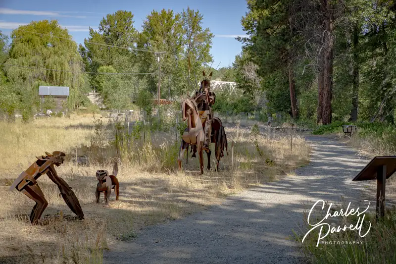
A short .2-mile trail runs along the river and loops back to the picnic area. And along the way it’s dotted with works by sculptor Smoker Marchand. These sculptures focus on the salmon and the original inhabitants of the Methow Valley. About half of the level hard-packed dirt trail is accessible, and there are several benches to sit down and take a break along the way. After the halfway point there are nine boulders along the trail, which represent the nine dams that the salmon encounter on their journey to the Pacific Ocean. Some slow walkers may be able to get around the boulders, but most spaces are too tight for wheelchair-users, so you’ll have to double back. Still it’s a nice spot to stop, enjoy a picnic, and peruse the sculptures.
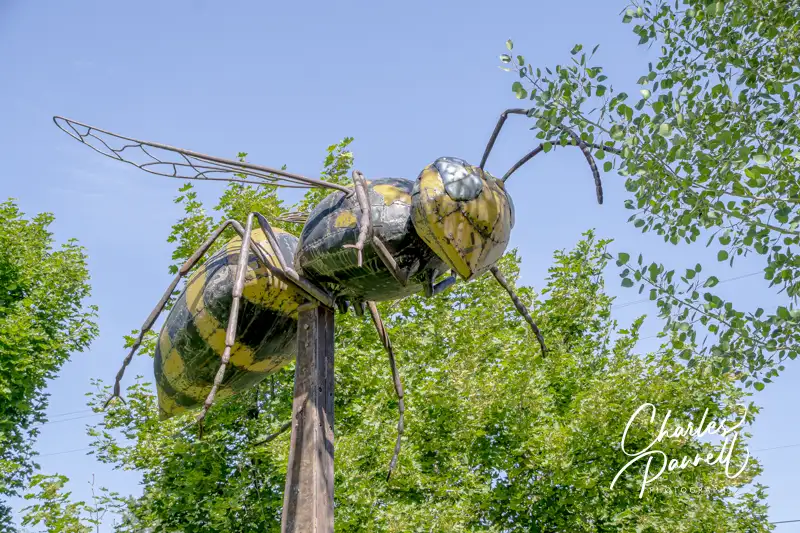
Created by local artist Barry Stromberger, this giant metal yellowjacket sculpture sits on a 15 foot pole in Twisp Commons Park. What makes it unique is that it was crafted from a 1951 Plymouth Cranbrook that was pulled from the Methow River, in an effort to improve the salmon habitat. Why a yellowjacket? It’s widely believed that the name of the town (Twisp) comes from the Okanagan word txʷəc’p, which supposedly translates to yellowjacket or wasp. And in keeping with the theme, the local high school also has a yellowjacket as a mascot.
There’s accessible parking in front of the Methow Valley Community Center across the parking lot from the sculpture. And if you need local visitor information, there’s ramped access to the building which has a nice selection of Methow Valley brochures and maps in the lobby. It makes a nice quick stop off of Highway 20.
Located off of Highway 14 on the north shore of the Columbia River, the Wishram Locomotive makes a nice stop in Southwestern Washington. Although there’s signage at the Wishram turnoff, about three miles west of Maryhill Winery, that’s pretty much the last directional beacon you’ll find. Still it’s a fun off-the beaten-path adventure. Just follow Wishram Road as it heads down towards the river, and continue on Main Street when you get to town. Then, just past Bunn Canyon Road, make a left into the train depot parking lot. Basically if you stay away from the “not a through street” signs and head towards the river you’ll be just fine.
There’s accessible parking near the depot entrance, but the locomotive is located in a small park in front of the station. The 1932 Baldwin Locomotive #2507 once pulled the Empire Builder train as it headed from the Pacific Northwest to Chicago. Today it’s housed in a protective enclosure, surrounded by a wrought iron fence. You can still get a good gander it, but the fence stops folks from climbing on and defacing the locomotive. There’s a level sidewalk around the locomotive, and some standard picnic tables in the shade on the nearby grassy area. And although there are no real facilities at this stop, there is an accessible porta potty in the parking lot. As an added bonus, there are great river views on the way to and from Highway 14.
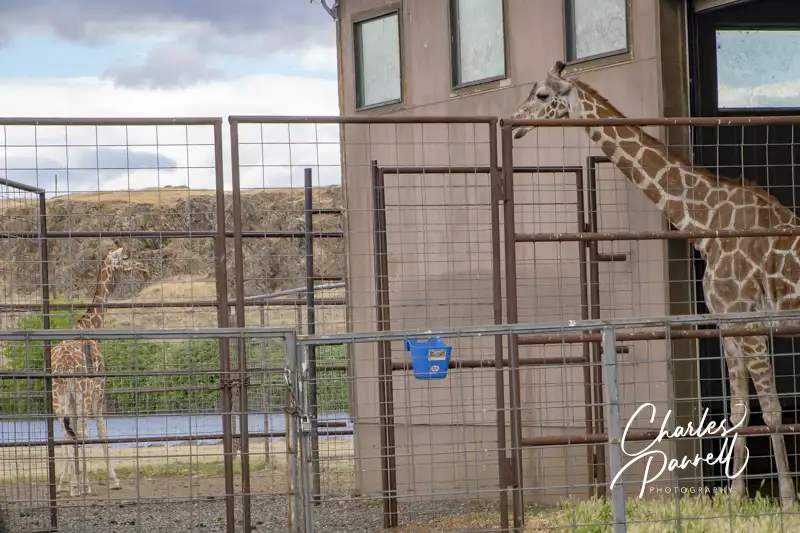
Located on Highway 14 near the town of Lyle in Southwestern Washington, Schreiner Farms is home to a number of exotic animals. Even better, they welcome visitors as long as they abide by a few simple rules. They ask visitors to stay in their own vehicles, remain on the main main road, yield to farm traffic and refrain from smoking and littering. Best of all — there’s no admission charge.
A working cattle ranch, Schreiner Farms also raises a variety of exotic animals. As you cruise along the main ranch road you’ll see enclosures on each side, filled with antelope, emu, ostrich, deer, elk, zebra and llamas. Sometimes the animals get close to the fence, and sometimes they don’t, so sightings are truly the luck of the draw. That said, at the turn-around spot — which is clearly marked — you’ll probably get a good gander of the resident giraffes. Their barn is close to the road and more often than not they hang out there. Either way, this is a great quick road trip stop along Highway 14, as you never know what you’ll see.
Although there’s no shortage of fun attractions in Pigeon Forge and Gatlinburg, sometimes it’s nice to take a break from the city. Fortunately these popular tourist hubs are just a stone’s throw away from the incredibility scenic Great Smoky Mountains National Park (www.nps.gov/grsm/). The good news is, even though this Appalachian gem is America’s most visited national park, there’s still plenty of room to spread out and enjoy a quiet slice of Mother Nature. So pack a picnic lunch and plan a day away from the hustle and bustle of the city, and enjoy a wheelchair-accessible Smoky Mountain day trip
Get Your Bearings
Getting to the park is easy. From Pigeon Forge, just follow Highway 321 south to Gatlinburg, then head west on Highway 441. And once you get to the park, make sure your first stop is Sugarlands Visitor Center.
There’s plenty of accessible parking in front, with level access over to the main building, and to the accessible restrooms on the far side. Inside there’s ample room to maneuver a wheelchair through the small museum and bookstore, and to the ranger information desk. There’s also level access and accessible seating in the theater, where a 20-minute film about the park is shown throughout the day. It’s the perfect place to get a good overview of the park and pick up a few maps. The one thing you won’t find at the Sugarlands Visitor Center — or anywhere else in the park — is a fee collection station, as there is no entrance fee for Great Smoky Mountains National Park.
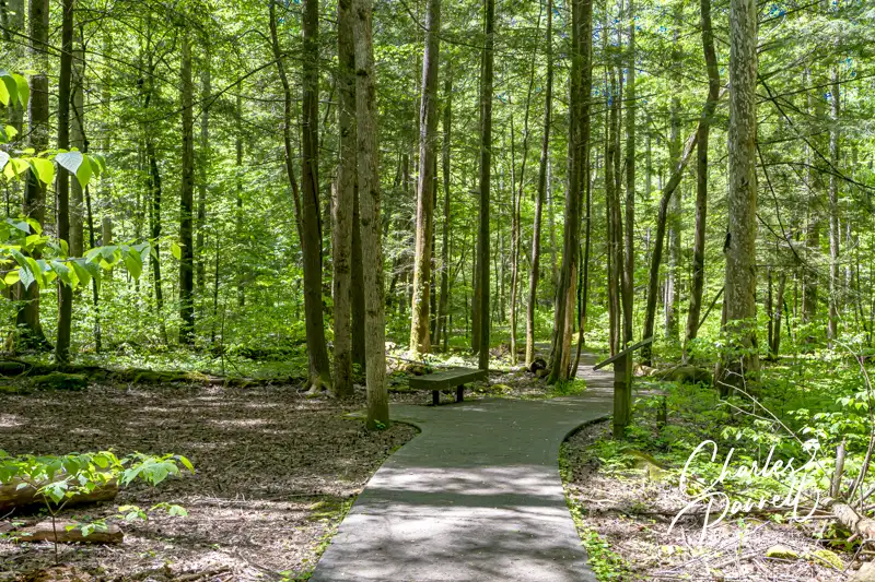
Take a Wheelchair-Accessible Smoky Mountain Hike
Sugarland Valley Nature Trail in Smoky Mountain National Park, Tennessee
Unfortunately the trail at Sugarlands Visitor Center is not accessible, due to rocks and ruts along the way. That said there is a nicely accessible option just down the road — the Sugarland Valley Nature Trail. It’s located just south of the Sugarlands Visitor Center on the east side of Newfound Gap Road.
This nicely accessible trail was made possible through a public-private partnership, with $60,000 in federal funding and $90,000 in private donations. There’s plenty of accessible parking near the trailhead, and level access over to the paved half-mile loop. Along the way interpretive plaques describe the natural features of this area, which includes a greater variety of salamanders than anywhere else in the world.
It’s also a great place to spot wildlife, including deer, wild turkeys and even bear. And there’s even some unintended evidence of the robust bear population, as a bear tracked through the wet concrete when the trail was built. There are also a few rock chimneys from old cabins along the way, and you just can’t beat the view of the West Prong of the Little Pigeon River. It’s a nicely shaded walk, so it’s an ideal choice for a hot day.
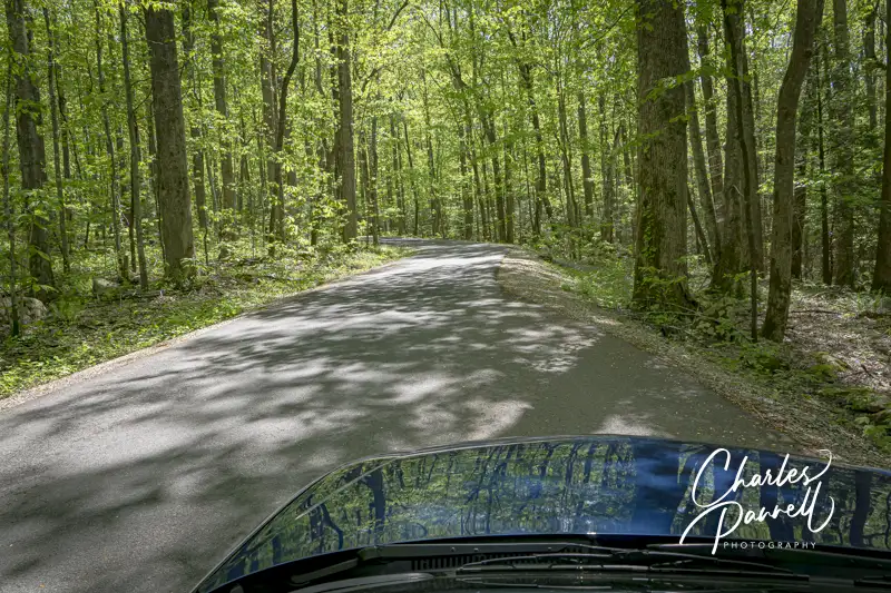
A Scenic Drive to Remember
Roaring Fork Motor Trail in Smoky Mountain National Park, Tennessee
Finally, get an entirely different view of the forest on the Roaring Fork Motor Nature Trail, located just outside of Gatlinburg. It’s easy to find — just follow Highway 441 east from the Sugarlands Visitor Center, and turn right at Stoplight #8 on Historic Nature Trail (Airport Road). You can’t miss it — Bubba Gump’s is on the corner. Continue along the road till you hit Cherokee Orchard Road. Bear right on Cherokee Orchard Road, which will take you to the one-lane Roaring Fork Motor Nature Trail.
This 5.5-mile loop drive winds through the forest and offers a quiet look at the national park. Pick up a brochure at the beginning of the drive to learn more about the history and ecological diversity of the area. Best of all, RVs and buses are not permitted on this drive, so it’s a great way to dodge the crowds.
The drive begins in a dense hardwood forest filled with chestnuts, oaks, maples and magnolias. The trees arch over the road in places; and in season you’ll even get a glimpse at the tulip trees in bloom. The road passes by 25-foot high Grotto Falls before it transitions into a hemlock forest. Old log cabins dot the landscape, and there’s even a grist mill along the way. Last but not least, the route eases past the “place of a thousands drips”, which becomes a mini-waterfall in wet weather. It’s a very pleasant drive, but it’s important to note that the road is closed in the winter. Additionally, it’s an absolutely gorgeous fall foliage route.
Located just west of Spokane, Way Out West Statue Farm is worth a stop on any Interstate 90 road trip. Owned by two brothers who relocated from downtown Spokane, this rural property allows them plenty of room for expansion. You get your first glance of the property on the north frontage road while driving east on Interstate 90. Fortunately it’s not hard to backtrack. Just take the next exit (272), cross the freeway, then head west on the frontage road. The parking lot is not paved and it has gravel to fill in the low spots, so it’s not that great for most wheelchairs. That said, the whole area where the metallic works of art are displayed is level. The pathways are narrow and not paved, but it’s still a great choice for slow walkers. But if you have a little help it may also work for some wheelchairs.
The selection of yard art is second-to-none at the Way out West Statue Farm. You’ll find a little bit of everything, from signs and metal sculptures to small decorations and larger works of art. A chicken here, an alligator there, flamingos planted in the flowerbeds and a cactus or two are just a few examples of the offerings; but trust me, there’s much more. Everything is for sale, but browsers are also welcome. There are no pushy salespeople there; in fact if you want to buy something you’ll have to flag down one of the owners who are usually roaming the grounds in golf carts. If you can’t find them, then just ask — the other tenants are usually out and about and they will go and fetch them for your. As one friendly guy told me “It’s part of our job”. Either way it’s a fun stop, and I came home with a cool “welcome rooster”. And had a wonderful conversation with the owner, who wanted to make sure the rooster was going to a good home. This fun roadside attraction is also worth a revisit, as the selection constantly changes, but the owners are always friendly. And don’t miss their trademark alien spaceship.
Road trips are an excellent vacation choice for wheelchair-users and slow walkers. They offer the freedom to motor through the countryside at your own pace, and stop whenever you want. There’s no tour group to keep up with, no mandatory stops at oddball attractions, and no worries about personality conflicts with other tour participants. You can go wherever you want, and do whatever you choose on a road trip. Additionally, road trips are a great way to explore small towns that are often overlooked on large group tours. Of course road tips require some serious planning and advance research, so here are some tips to help you plan a wheelchair accessible road trip (emerginghorizons.com/wheelchair-accessible-road-trip-tips/)
Half the fun of a road trip is stopping at quirky roadside attractions along the way. It’s a great way to take a break, get off the highway and get some fresh air. And although you’ll probably not find these fun and funky stops splattered across the pages of high end travel magazines, they are all great spots to take a break and enjoy the local color. So here’s a fun assortment of wheelchair-accessible roadside attractions to consider for your next getaway.