Historic Harvey Houses of the Southwest
Arizona, Belen, California, Casa Del Desierto, Castaneda, Grand Canyon, Harvey House, historic, Kelso, Las Posada, Needles, New Mexico, Painted Desert, Puye, road trip, Santa Fe, Williams
Fred Harvey is a bit of a legend in the hospitality industry. Back in 1876, long before railroad dining cars were part of the rolling stock, he realized the need for restaurants along the major rail routes. To remedy the situation, he negotiated a contract with the Santa Fe Railroad, and opened the first of many Harvey Houses in Topeka, Kansas along the rail line. These restaurants were known for their generous portions and quality furnishings, and of course the Harvey Girls, who fed hungry passengers in the time it took to service the trains and change the crews. As time went on, Harvey expanded his empire to include hotels and resorts, and at the time of his death he operated 47 restaurants and 15 hotels.
And although many of these historic properties have faded into oblivion, you can still find remnants of the Harvey empire throughout the Southwestern US. Some buildings are in ruins, while others have been renovated; and there are even a select few where you can spend the night. And although access wasn’t a consideration during Fred Harvey’s lifetime, thanks to some access upgrades, today wheelchair-users and slow walkers can enjoy some of the remaining properties. So check out these historic Harvey Houses on your next road trip through the Southwestern US.
Casa Del Desierto
Barstow, CA
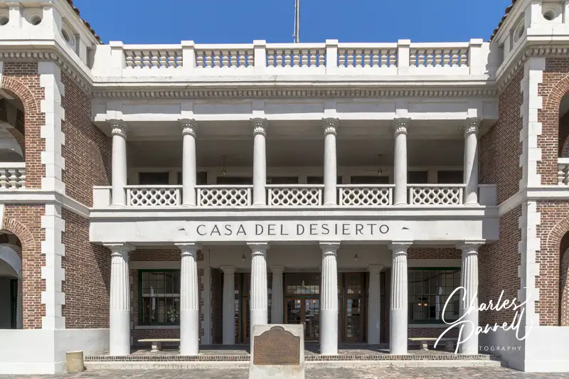
Located in Southern California, Casa Del Desierto was considered the crown jewel of the Harvey House chain. It opened its doors in 1911, and not only did it house a restaurant, but it also provided comfortable overnight accommodations for passengers on the the Atchison Topeka and Santa Fe Railway. The building was renovated in 1999, and today it houses the local visitor center as well as the excellent Western America Railroad Museum (emerginghorizons.com/western-america-railroad-museum/)
– both of which have good wheelchair access. And if you’d just like to stop by and glance at the exterior of the historic structure, you can do that too.
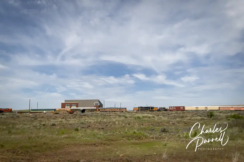
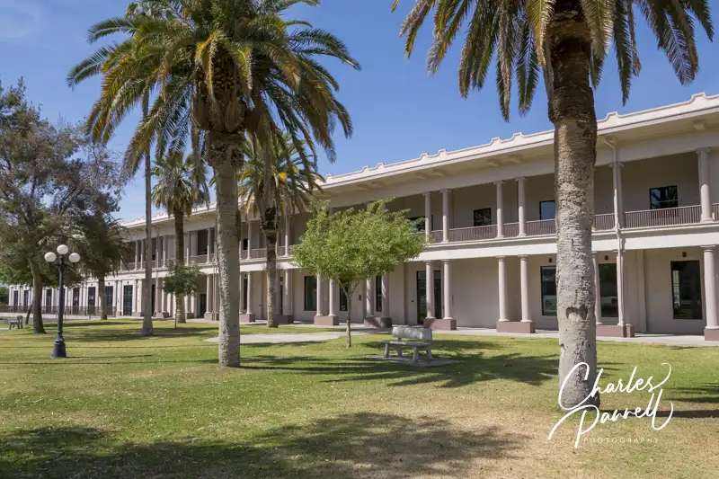
Kelso Depot
Kelso, CA
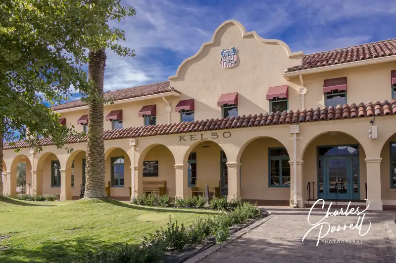
Located in the Mojave National Preserve, Kelso Depot (nps.gov/moja/planyourvisit/visitorcenters.htm wasn’t a Harvey House, but it’s definitely worth a mention. It was constructed in 1924 by the Los Angeles & Salt Lake Railroad as competition for the popular Harvey Houses operated by the Santa Fe Railroad. Today it houses the visitor center for the Mojave National Preserve. It also has several restored rooms that are open to the public. These include the baggage room, ticket office and two dormitory rooms. Accessible parking is available in the parking lot, with level access to the depot buildings. And even if the building isn’t open, you can still get a gander at the lunch counter, vintage desks and old equipment through the large front windows. Additionally, the restrooms are always open, so it’s a good spot to take a rest break.
El Garces
Needles, CA
Named for Father Francisco Garces — the first European to cross the Mojave Desert — El Garces (nps.gov/places/el-garces.htm) was once said to resemble a Greek temple. This Southern California train depot housed a hotel and restaurant. After the depot was closed, it fell into disrepair and was subsequently shuttered. Fortunately the City of Needles came to the rescue in 1999, and purchased the building; which was added to the National Register of Historic Places in 2002. In 2014 the city embarked on an ambitious $5 million renovation project to restore this Needles landmark to its former glory. Today the finished project transports visitors back to the golden age of rail travel, and makes a nice stop on an Route 66 road trip.
There’s accessible parking on the side with level access over to the front of the depot, which is surrounded by tall palms and flanked by stately white columns. Although the building is only sporadically open, visitors can still get a look at the restored interior through the large glass windows. There’s also barrier-free access around to the back — track side — of the building, and level access to the back door. A majestic fountain dominates the courtyard near the back door, and it’s a pleasant spot to rest and admire the building. And like the front, large windows line the back of the building, so it’s easy to get a peek inside.
Santa Fe Depot
Kingman, AZ
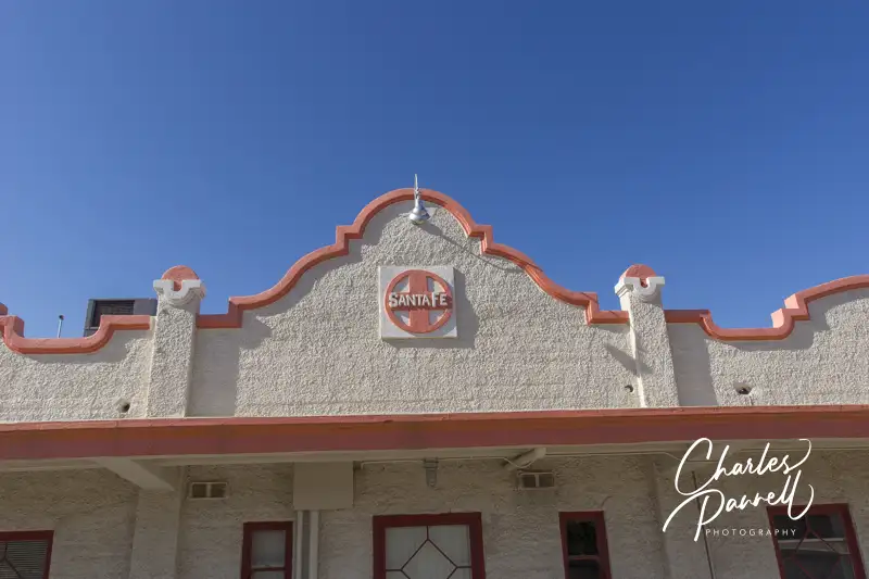
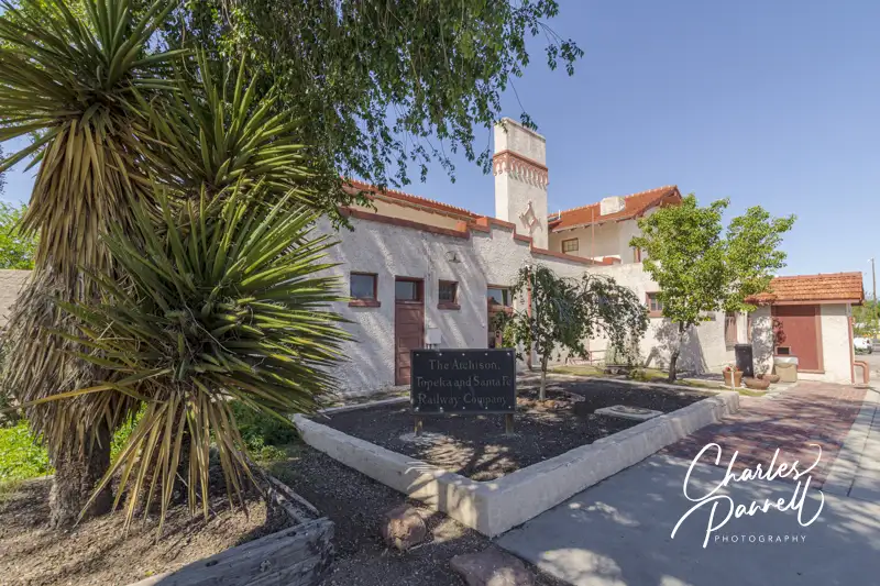
The beautifully restored Santa Fe Depot is located on the corner of 4th Street and Andy Divine Avenue in downtown Kingman. Unfortunately the Santa Fe Eating House, which was staffed by Harvey Girls, has been demolished. It once sat across from the Santa Fe Depot, but today all that’s left of it are a few remnants of the foundation. Still it’s worth a stop to see the depot.
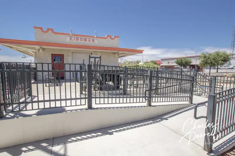
There’s accessible parking in the small lot, with ramp access up to the 1907 depot. The Kingman Railroad Museum (kingmanrailroadmuseum.com) is located on one side of the building, while the Amtrak waiting room is located on the other side. There’s level access to the depot and the museum, and there are accessible restrooms inside the depot. It’s definitely worth a stop for history buffs, as the building is on the National Register of Historic Places.
Fray Marcos Hotel
Williams, AZ
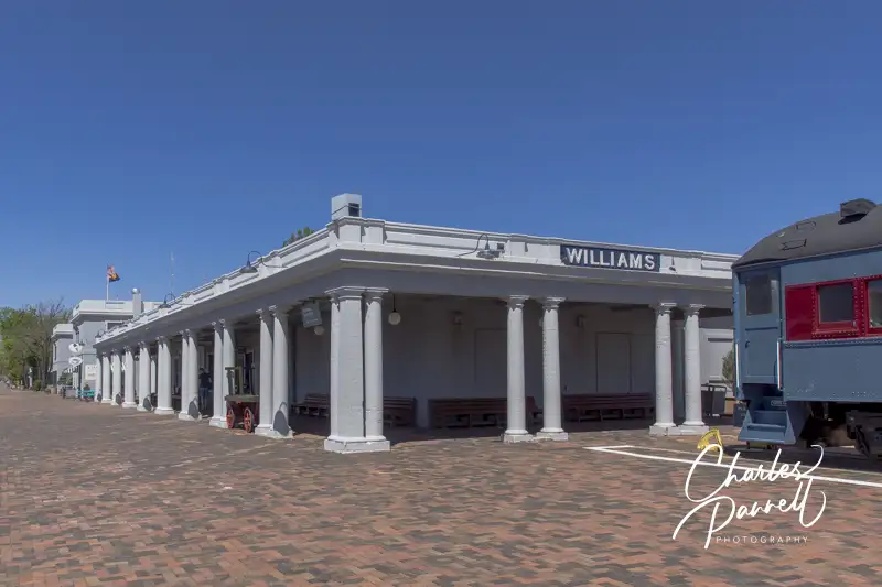
The Fray Marcos Hotel, and the adjoining depot were opened in 1908. This Harvey House had 43 guest rooms at its peak. Today the depot is still in operation, while the former hotel houses the Grand Canyon Railway (thetrain.com) administrative offices. Accessible parking is located near the Williams Depot, with level access to the track side of the station. Take some time to admire the exterior, then pop inside for a look at the former Indian Building — you can’t miss it, as it’s the room with the massive fireplace.
The old hotel lobby is adjacent to the Indian Building, next to the stairs that lead up to the Grand Canyon Railway offices. There are some old photographs in the lobby, and the room exudes a definite historic vibe. Although the depot is deserted most of the day, traffic picks up when the daily Grand Canyon train arrives and departs. Still with a little advance planning, you’ll have the place to yourself.
El Tovar & Bright Angel Lodge
Grand Canyon National Park, AZ

Grand Canyon National Park, which is located north of Williams, is home to two historic Harvey Houses. Perched on the south rim of the canyon, El Tovar and Bright Angel Lodge both feature Mary Colter’s signature southwestern touches.
El Tovar (grandcanyonlodges.com/lodging/el-tovar-hotel) first opened in 1905, and although it was considered a luxury hotel, guests still shared one bathroom at the end of the hall. Today the property boasts modern access features, including a ramped accessible entrance on the canyon side, and several wheelchair-accessible guest rooms.
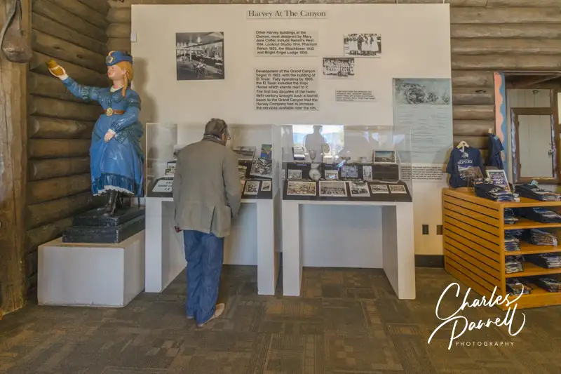
Bright Angel Lodge (grandcanyonlodges.com/lodging/bright-angel-lodge-cabins) was constructed in 1935 as a budget alternative to the El Tovar. Although there are no accessible rooms at the Bright Angel Lodge, it’s still worth a visit to see the Harvey House exhibit in the Bright Angel History Room. There’s good wheelchair access throughout the Bright Angel History Room, which features artifacts from the two Harvey Houses, as well as old photos, an 1880 Harvey House dinner gong, and even a vintage Harvey Girl uniform. It also includes information and photos from a Harvey Indian Detours excursion, which took train passengers on overnight trips to nearby Native American sites.
La Posada
Winslow, AZ
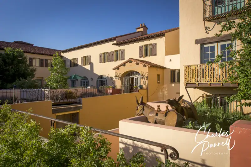
Over in Winslow, Arizona, La Posada (laposada.org) was added to the Harvey family in 1929. And although Mary Colter received wide recognition for her Grand Canyon buildings, she always considered La Posada her masterpiece. Access is good throughout this historic property, with accessible parking in front, and a level sidewalk to the front entrance.
Even if you don’t overnight there, make sure to stop and enjoy a short walking tour, as the property is filled with lots of nooks and crannies that contain historic photos and artifacts. Although the building lacks an elevator, the majority of the artifacts are located on the first floor. Out back, the Affeldt Mion Museum is housed in the 1930 depot, and contains exhibits about the history of the Las Posada, Fred Harvey and Mary Colter.
The Turquoise Room, which faces the railroad tracks, once served as the Harvey House lunch room. Today the menu offers a good selection of southwestern and traditional favorites. And for a real nostalgic feel, the waitresses are even dressed in in traditional Harvey House uniforms. Additionally, if you’d like to spend the night at the Las Posada, they also have a nice wheelchair-accessible guest room on the first floor.
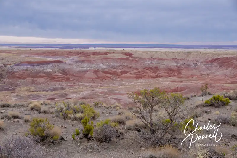
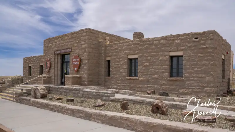
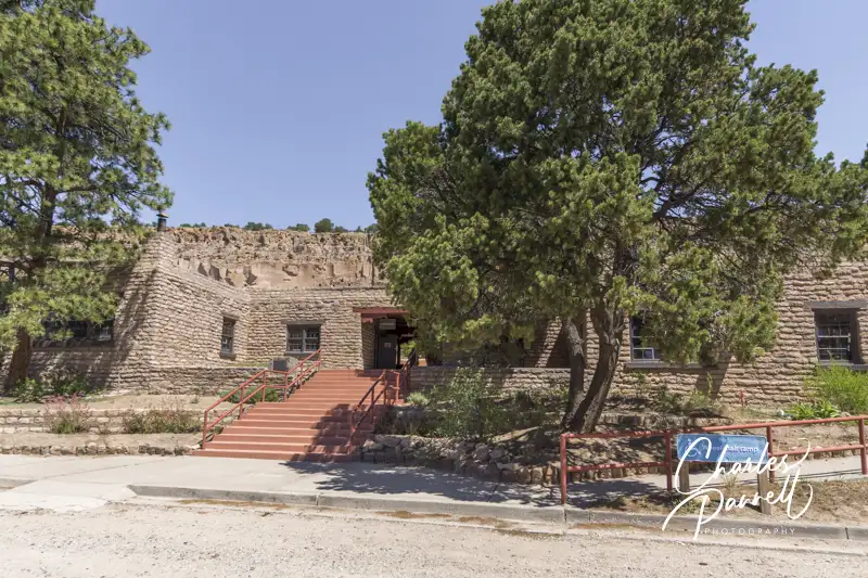
Painted Desert Inn
Petrified Desert National Park, AZ
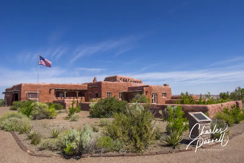
Located east of Winslow, the Painted Desert Inn (nps.gov/pefo/learn/historyculture/pdi.htm) officially opened in 1940 on the site of the former Stone Tree House, which once provided Route 66 travelers with food, souvenirs and lodging. Sadly the war brought an end to the boom days and the Painted Desert Inn was closed in 1942. Five years later the Fred Harvey Company took over management and hired Mary Colter to renovate the property; and the legendary Harvey Girls were brought to the Petrified Forest.
The property operated until 1963, but the inn was saved from the wrecking ball due to a massive public outcry. Finally in 1987 it was declared a National Historic Landmark, and the property was rehabilitated and returned to its former glory. Today you can see the old dining counter and lunch room, complete with vintage place settings. Access has also been improved over the years, with level access to most areas of the inn, and plenty of room for wheelchairs and scooters. After you’re done browsing through the inn, don’t miss the colorful desert view from the accessible viewpoint in back of the inn.
Belen Harvey House
Belen, NM
This 1910 Belen Harvey House (harveyhousemuseum.org) once contained a large lunch room, a formal dining room, a newsstand and an upstairs Harvey Girls dormitory. Today it houses a museum and an adjacent restaurant. There’s good access throughout the museum which contains lots of Harvey House memorabilia, including old photos, dishes, uniforms and even menus. There’s also a number of exhibits about the history of the railroad, and even some old railroad equipment on display. There’s no elevator access to the second floor, but the bulk of the exhibits up there focus on Belen history, rather than the Harvey Houses. As an added bonus the museum is staffed by volunteers who love to talk about the Harvey House heyday.
The Whistle Stop Café is also worth a stop while you are there. This casual eatery includes home made treats like muffins, carrot cake, cobbler and a variety of soups. Everything is delicious, and all proceeds from the café go to help support the museum.
Puye Rest House
Espanola, NM
Located well off the main train line in the Santa Clara Pueblo, this Harvey House was part of the Indian Detours program. Built on tribal land in the 1920s, the Puye Rest House (puyecliffdwellings.com/tours/harvey-house) hosted guests who traveled on the “Chili Line”, and were then transferred to the Santa Clara Pueblo in covered wagons in the early years, and in Model Ts in later years. The tours operated from 1925 to 1939, and the big attraction of this location was the hilltop cliff dwellings in back of the hotel.
Today the two buildings that made up the Harvey House are now an interpretive center and a gift shop, and although the cliff dwellings aren’t accessible, the buildings are very doable for wheelchair-users and slow walkers. Most of the exhibits in the interpretive center are focused on the history of the Santa Clara Pueblo, and the excavation of the cliff dwellings in 1907. Still it’s a chance to go inside the historic Harvey House building. There’s also a nice view of the cliff dwellings from the back porch. And if you just want to look at the outside of this historic building, it’s definitely worth the drive.
Castaneda House
Las Vegas, NM
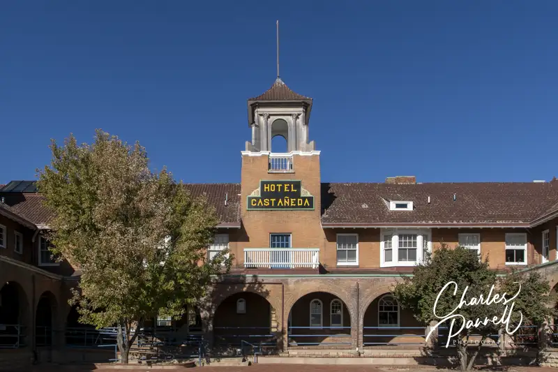
Last but certainly not least on our Harvey Houses of the Southwest tour is the Castaneda House (emerginghorizons.com/the-castaneda-hotel-a-wheelchair-accessible-harvey-house/), which opened in 1898. It closed in 1948 and was shuttered until a local investor purchased it in 2019. Today the restored property has the ambience of yesteryear, with the access features of modern times.
The Mission Revival style building once housed 37 guestrooms, a 108-seat dining room a 51-seat lunch counter, and a cluster of railroad offices. Today the renovated property has 22 suites; and if you look carefully in the rooms, you can see vague outlines of the former room borders on the floors. The hallway doors to the original rooms were also left intact — some now go to storage rooms, while others are merely decorative. And there’s also a nice wheelchair-accessible guest room with a roll-in shower. All in all, the Castaneda Hotel features the charm of the yesteryear, and the comforts and access features of today.
Barrier-Free Travel
the Grand Canyon
for Wheelchair-users and Slow Walkers