The Grand Canyon is definitely a must-see on the life bucket list. Most people arrive at this popular national park by car, as there’s not exactly an international airport on the rim. That said, there’s an alternative way to get to the South Rim of the Grand Canyon – ride the rails on the Grand Canyon Railway (www.thetrain.com)). And not only is this journey scenic, it’s also wheelchair-accessible. So check out this fun excursion on your next Arizona visit.
The Historic Williams Depot
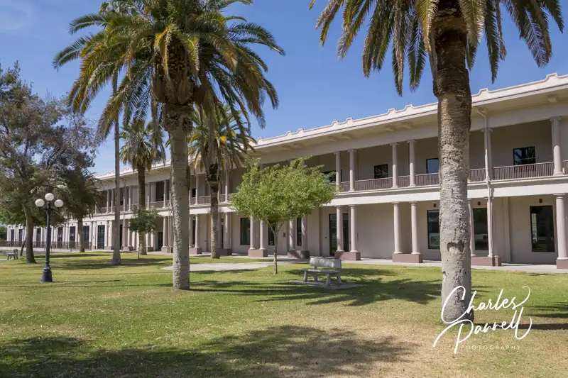
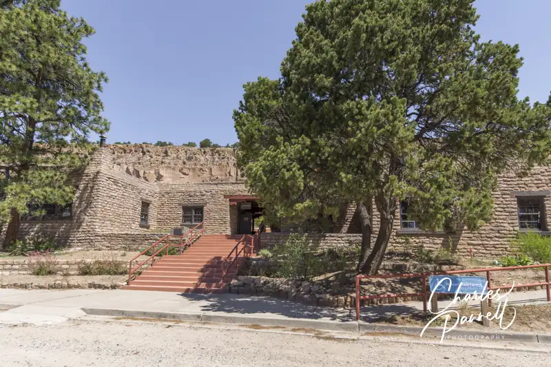
This scenic rail excursion begins at the Williams Depot; and despite the historic nature of the building, there’s good wheelchair access to all areas. The Fray Marcos Hotel — which opened to the public in 1908 — once occupied the left portion of the depot. Today most vestiges of this 43-room Harvey House are gone;, however there are some vintage photos in the former lobby which is located next to the gift shop.
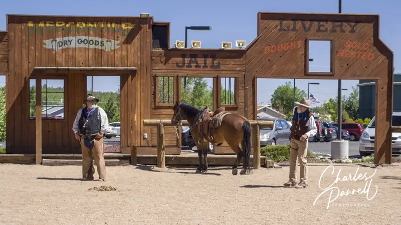
And while you’re at the depot, there’s also a little entertainment before boarding the train. The local marshal and the nefarious Cataract Creek Gang stage a wild west shootout before the train departs. There is level access to the show area, and wheelchair-accessible seating is available in front of the bleachers or at nearby tables. Then after the shootout, everyone heads over to the train.
Cataract Creek Gang at the Grand Canyon Railway
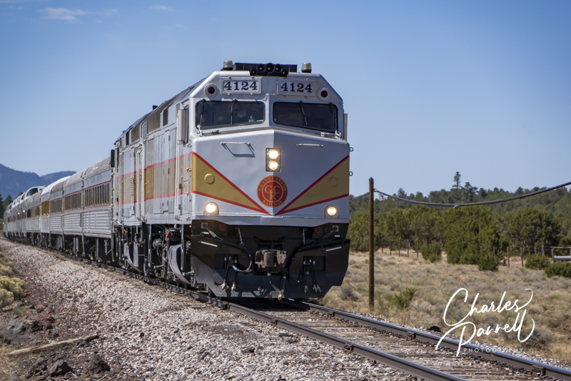
Access Aboard the Railway
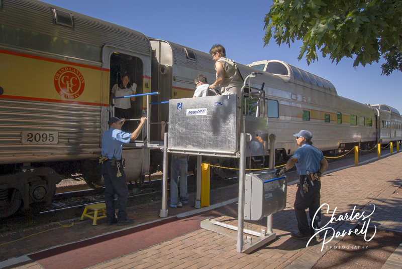
Boarding the Grand Canyon Rail
The excellent access at the Grand Canyon Railway continues with pre-boarding, when wheelchair-users and slow walkers are boarded before the rest of the passengers. Access is good on this historic train; and train buffs are wowed by the vintage train cars which are pulled by diesel locomotives. There are six classes of service, with Pullman, Coach and First Class being the most accessible.
The Harriman-Style Pullman cars have bench seats that flip so families can sit together and windows that open; while the Budd coach cars have front facing bench seats and air conditioning. The first-class cars have comfortable reclining seats, large windows and air conditioning. All of these cars can be accessed by a portable lift, and they all have wheelchair tie-downs and nearby companion seats. Accessible restrooms with grab bars, wide doorways and ample pathways are also located in these cars
And of course, if you just can’t make up your mind about which class to book, you can always mix classes; and take one class going up and another on the return trip.
The Trip and Beyond
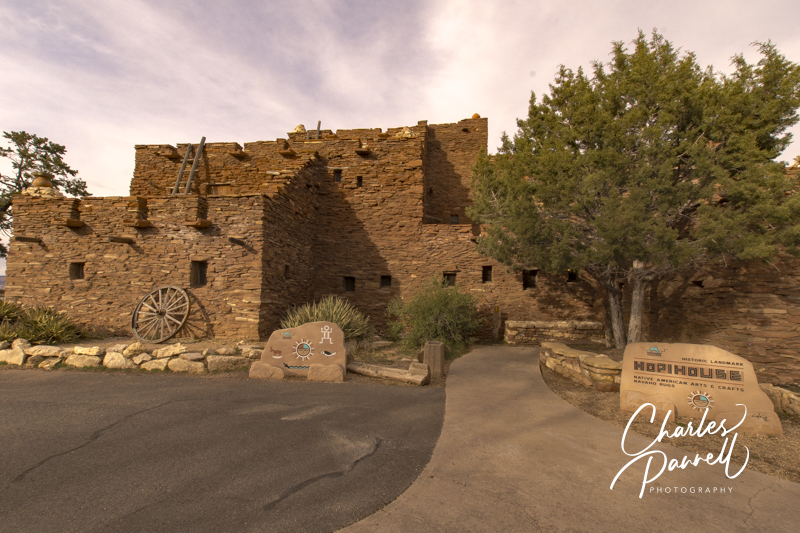
Hopi House on the South Rim of the Grand Canyon
The journey to the South Rim of the Grand Canyon takes about two hours, and you just can’t beat the passing scenery. As an added bonus, roving musicians entertain passengers with western songs along the way. And on-board attendants are always available to field questions and suggest activities for the stop on the South Rim.
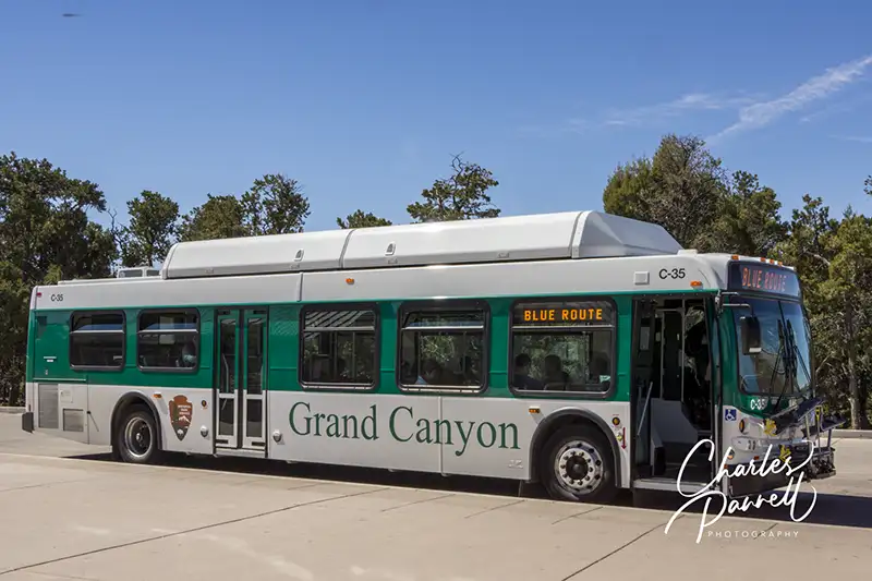
Once the train arrives, passengers can explore the South Rim on the the wheelchair-accessible Grand Canyon shuttle. The return train departs for Williams about three hours later; however if you’d like to spend more time on the South Rim you can extend your visit for a night or two. The railway also offers South Rim hotel packages with wheelchair-accessible rooms. And if you’d like to spend the night in Williams after the train returns, they also have wheelchair-accessible rooms at the Grand Canyon Railway Hotel.
No matter which package you choose, you’ll have a great time on this scenic railway. Not only is the scenery second-to-none, but the railway employees are extremely accommodating. It’s a great wheelchair-accessible way to experience the Grand Canyon.
Barrier-Free Travel the Grand Canyon for Wheelchair-users and Slow Walkers
There’s a certain seductive allure to Sedona. Some folks come for the mystical experience, while others enjoy gallery hopping. And then there’s the scenery. You just can’t beat the red rock formations that literally surround this Northern Arizona enclave. And the good news is, a good chunk Sedona’s red rock beauty is accessible to wheelchair-users and slow walkers.
Red Rock Scenic Byway
Red Rock Scenic Byway
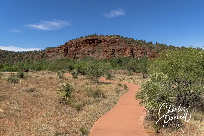
One of the best ways to enjoy Sedona’s red rock beauty is to take a drive on the Red Rock Scenic Byway. This popular route is located off of Interstate 17. Just take exit 298, and once you cross the Dry Beaver Creek bridge, the show begins.
The 7.5 mile scenic drive, which winds through the majestic landscape, is often referred to as a “museum without walls”. As you pass Oak Creek Village, the scenery becomes more dramatic. Bell Rock, one of Sedona’s four vortices, is located just past Oak Creek Village on the right. You can’t miss it. Bell Rock is one of the more accessible red rock formations, as the upper part of Bell Rock Trail is wide, level and made of hard-packed dirt. It’s doable for most wheelchair-users, however you can also get a great view of the iconic formation from the parking lot overlook.
Be sure to stop at nearby Courthouse Butte to admire the expansive scenery. And don’t miss the Chapel of the Holy Cross (chapeloftheholycross.com), which is built into the red rock buttes. There are a few accessible parking spots near the sanctuary, and golf cart transportation is available from the remote parking area. The chapel features ramp access, but some manual wheelchair-users may require assistance because of the pitch. Still it’s worth a stop even if it closed, just for a view of the impressive front facade.
Just up the road, the Red Rock Scenic Byway ends at Highway 89A. All in all it only takes 20 minutes to drive the route, but allow for extra time for lots of photo stops. And even though a Red Rock Pass is required for hikers, it’s not required for quick photo stops of 15 minutes or less.
Red Rock State Park
Mesquite Interpretive Loop
Red Rock State Park (www.azstateparks.com/red-rock), which is located on Highway 89A South is also worth a visit. There are a two accessible trails in the park, but they don’t offer much shade, so it’s best to go early in the day.
Accessible parking is located near the visitor center, with ramp access down to the building. Inside there’s plenty of room to maneuver a wheelchair around the gift shop, ranger information desk and interpretive exhibits. Accessible restrooms are located near the front door, and there’s also level access to the theater and classroom next door. And don’t miss the hummingbird garden on the back patio.
The accessible Mesquite Interpretive Loop begins near the parking lot. This short trail features a paved level pathway around garden filled with native plants. There’s a shaded picnic area with accessible tables near the trail; and there’s also a shade structure located in the middle of this quarter-mile trail.
The longer Bunkhouse Trail begins behind the visitor center. Although you can access it from the parking lot, that pathway has a steep grade. Alternatively, there’s level access to the trail from the hummingbird garden. The paved trail is fairly level, although there’s a bit of a grade in the beginning. Power wheelchair-users won’t have a problem, but some manual wheelchair-users may require assistance. There are also some cracks along the paved trail, but other than that it’s fairly smooth rolling.
At about the .2-mile mark there’s an accessible hard-packed dirt trail down to the Kingfisher Bridge, which provides a pleasant — and shaded — view of Oak Creek. From there a hard-packed dirt path follows the creek for another .2 mile before the trail loses its access. All in all it’s a pleasant mile-long out-and-back hike.
Slide Rock State Park
Pendley Homestead House on the Pendley Homestead Trail
Finally, if you’d like to hit a local favorite, head on over to Slide Rock State Park (azstateparks.com/slide-rock). It’s located 20 minutes north of Red Rock State Park on Highway 89A. This park provides access to Oak Creek, and it takes its name from the rocks that many folks use as slides to get into the water.
Unfortunately the path down to the creek is not accessible, but there is a short trail that offers a scenic overlook of the canyon. That said, the admission is pretty steep ($20 to $30 per car, depending on the season) for just that trail; however if you have an Arizona State Park Pass, this park makes a nice lunch stop.
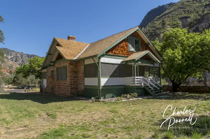
There’s accessible parking near the shaded picnic area — which has several accessible tables — and barrier-free access over to the Pendley Homestead Trail. This paved level trail leads past a small store, and by a display of vintage farming equipment, over to the old homestead which features a tractor display in the adjacent barn.
The trail then connects with the Cliff Top Trail which has a 75-foot paved path out to an accessible overlook that offers an expansive view of Oak Creek Canyon. All in all it’s about a quarter-mile round trip, and it makes for a nice stroll before of after lunch. And if you’d prefer to skip the hike, this piece of Sedona’s red rock beauty is easily visible from the the picnic area.
Barrier-Free Travel the Grand Canyon for Wheelchair-users and Slow Walkers
Fred Harvey is a bit of a legend in the hospitality industry. Back in 1876, long before railroad dining cars were part of the rolling stock, he realized the need for restaurants along the major rail routes. To remedy the situation, he negotiated a contract with the Santa Fe Railroad, and opened the first of many Harvey Houses in Topeka, Kansas along the rail line. These restaurants were known for their generous portions and quality furnishings, and of course the Harvey Girls, who fed hungry passengers in the time it took to service the trains and change the crews. As time went on, Harvey expanded his empire to include hotels and resorts, and at the time of his death he operated 47 restaurants and 15 hotels.
And although many of these historic properties have faded into oblivion, you can still find remnants of the Harvey empire throughout the Southwestern US. Some buildings are in ruins, while others have been renovated; and there are even a select few where you can spend the night. And although access wasn’t a consideration during Fred Harvey’s lifetime, thanks to some access upgrades, today wheelchair-users and slow walkers can enjoy some of the remaining properties. So check out these historic Harvey Houses on your next road trip through the Southwestern US.
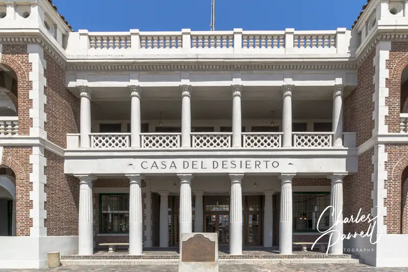
Casa Del Desierto Barstow, CA
Casa Del Desierto in Barstow, California
Located in Southern California, Casa Del Desierto was considered the crown jewel of the Harvey House chain. It opened its doors in 1911, and not only did it house a restaurant, but it also provided comfortable overnight accommodations for passengers on the the Atchison Topeka and Santa Fe Railway. The building was renovated in 1999, and today it houses the local visitor center as well as the excellent Western America Railroad Museum (emerginghorizons.com/western-america-railroad-museum/) – both of which have good wheelchair access. And if you’d just like to stop by and glance at the exterior of the historic structure, you can do that too.
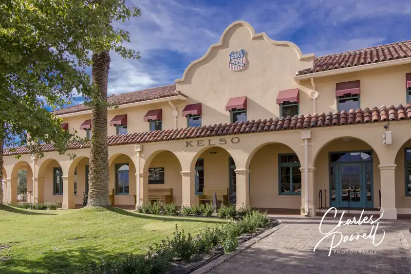
Kelso Depot Kelso, CA
Kelso Depot in Mojave National Preserve, California
Located in the Mojave National Preserve, Kelso Depot (nps.gov/moja/planyourvisit/visitorcenters.htm wasn’t a Harvey House, but it’s definitely worth a mention. It was constructed in 1924 by the Los Angeles & Salt Lake Railroad as competition for the popular Harvey Houses operated by the Santa Fe Railroad. Today it houses the visitor center for the Mojave National Preserve. It also has several restored rooms that are open to the public. These include the baggage room, ticket office and two dormitory rooms. Accessible parking is available in the parking lot, with level access to the depot buildings. And even if the building isn’t open, you can still get a gander at the lunch counter, vintage desks and old equipment through the large front windows. Additionally, the restrooms are always open, so it’s a good spot to take a rest break.
El Garces Needles, CA
El Garces Intermodal Transportation Facility in Needles, California
Named for Father Francisco Garces — the first European to cross the Mojave Desert — El Garces (nps.gov/places/el-garces.htm) was once said to resemble a Greek temple. This Southern California train depot housed a hotel and restaurant. After the depot was closed, it fell into disrepair and was subsequently shuttered. Fortunately the City of Needles came to the rescue in 1999, and purchased the building; which was added to the National Register of Historic Places in 2002. In 2014 the city embarked on an ambitious $5 million renovation project to restore this Needles landmark to its former glory. Today the finished project transports visitors back to the golden age of rail travel, and makes a nice stop on an Route 66 road trip.
There’s accessible parking on the side with level access over to the front of the depot, which is surrounded by tall palms and flanked by stately white columns. Although the building is only sporadically open, visitors can still get a look at the restored interior through the large glass windows. There’s also barrier-free access around to the back — track side — of the building, and level access to the back door. A majestic fountain dominates the courtyard near the back door, and it’s a pleasant spot to rest and admire the building. And like the front, large windows line the back of the building, so it’s easy to get a peek inside.
Santa Fe Depot Kingman, AZ
Santa Fe Depot in Kingman, Arizona
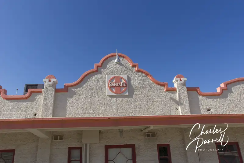
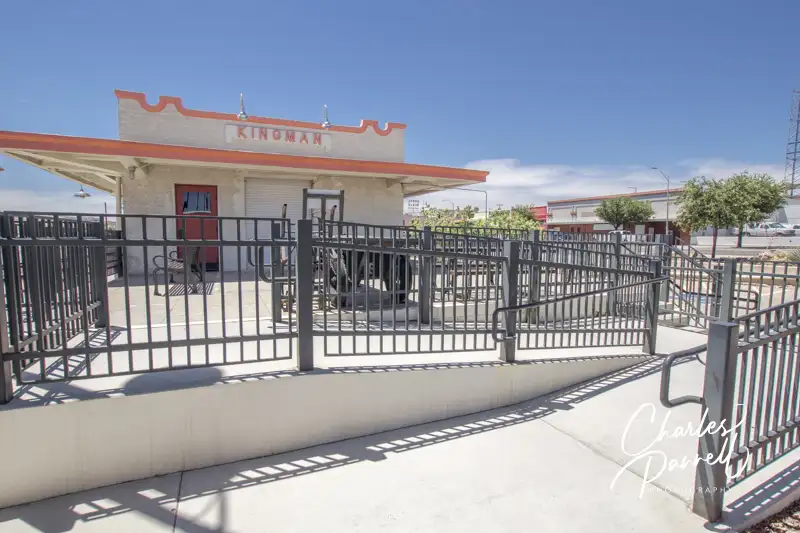
The beautifully restored Santa Fe Depot is located on the corner of 4th Street and Andy Divine Avenue in downtown Kingman. Unfortunately the Santa Fe Eating House, which was staffed by Harvey Girls, has been demolished. It once sat across from the Santa Fe Depot, but today all that’s left of it are a few remnants of the foundation. Still it’s worth a stop to see the depot.
Accessible Entrance Near Parking
There’s accessible parking in the small lot, with ramp access up to the 1907 depot. The Kingman Railroad Museum (kingmanrailroadmuseum.com) is located on one side of the building, while the Amtrak waiting room is located on the other side. There’s level access to the depot and the museum, and there are accessible restrooms inside the depot. It’s definitely worth a stop for history buffs, as the building is on the National Register of Historic Places.
Fray Marcos Hotel Williams, AZ
Depot at the Fray Marcos Hotel in Williams, Arizona
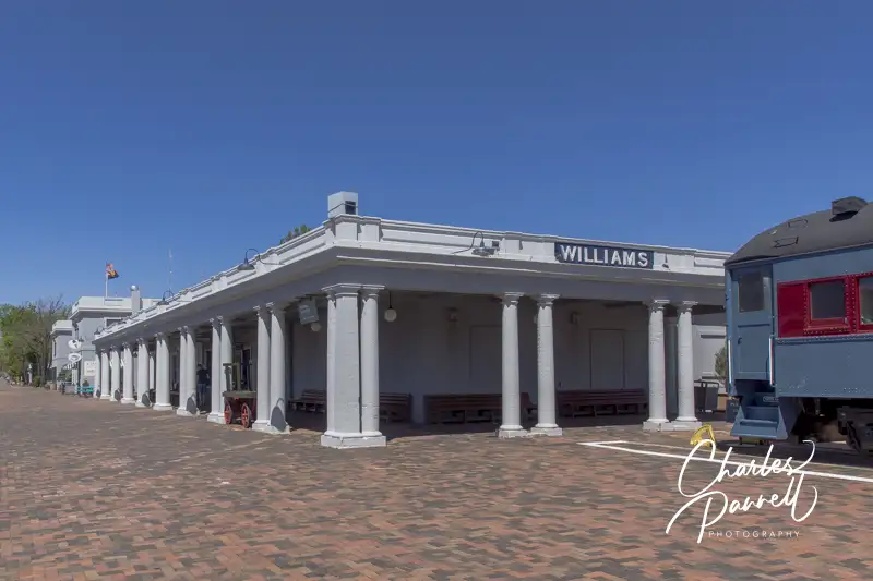
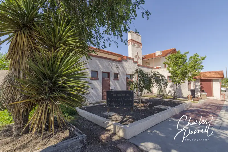
The Fray Marcos Hotel, and the adjoining depot were opened in 1908. This Harvey House had 43 guest rooms at its peak. Today the depot is still in operation, while the former hotel houses the Grand Canyon Railway (thetrain.com) administrative offices. Accessible parking is located near the Williams Depot, with level access to the track side of the station. Take some time to admire the exterior, then pop inside for a look at the former Indian Building — you can’t miss it, as it’s the room with the massive fireplace.
The old hotel lobby is adjacent to the Indian Building, next to the stairs that lead up to the Grand Canyon Railway offices. There are some old photographs in the lobby, and the room exudes a definite historic vibe. Although the depot is deserted most of the day, traffic picks up when the daily Grand Canyon train arrives and departs. Still with a little advance planning, you’ll have the place to yourself.
El Tovar & Bright Angel Lodge Grand Canyon National Park, AZ
El Tovar
Grand Canyon National Park, which is located north of Williams, is home to two historic Harvey Houses. Perched on the south rim of the canyon, El Tovar and Bright Angel Lodge both feature Mary Colter’s signature southwestern touches.
El Tovar (grandcanyonlodges.com/lodging/el-tovar-hotel) first opened in 1905, and although it was considered a luxury hotel, guests still shared one bathroom at the end of the hall. Today the property boasts modern access features, including a ramped accessible entrance on the canyon side, and several wheelchair-accessible guest rooms.
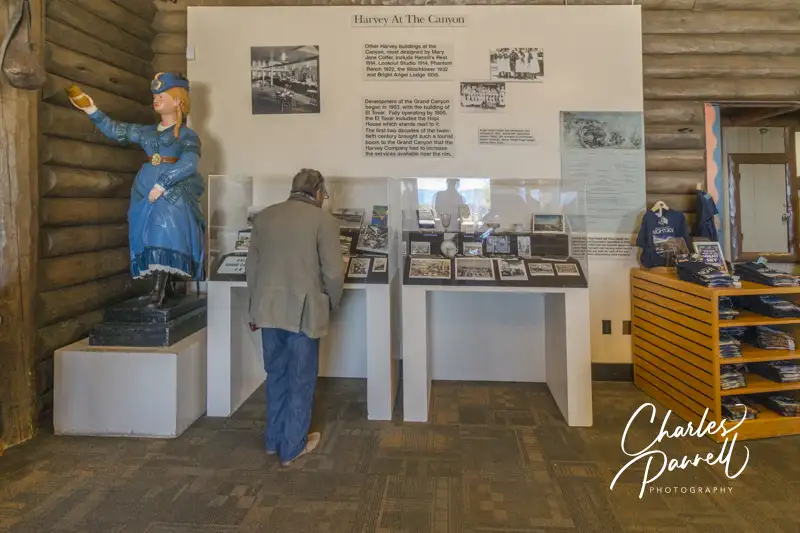
Harvey House Exhibit in the Bright Angel History Room
Bright Angel Lodge (grandcanyonlodges.com/lodging/bright-angel-lodge-cabins) was constructed in 1935 as a budget alternative to the El Tovar. Although there are no accessible rooms at the Bright Angel Lodge, it’s still worth a visit to see the Harvey House exhibit in the Bright Angel History Room. There’s good wheelchair access throughout the Bright Angel History Room, which features artifacts from the two Harvey Houses, as well as old photos, an 1880 Harvey House dinner gong, and even a vintage Harvey Girl uniform. It also includes information and photos from a Harvey Indian Detours excursion, which took train passengers on overnight trips to nearby Native American sites.
La Posada Winslow, AZ
The La Posada Hotel in Winslow, Arizona
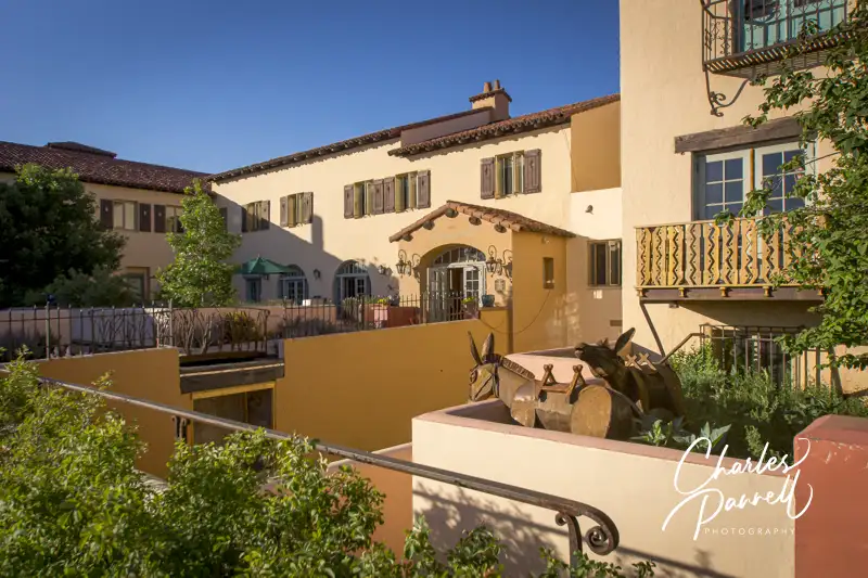
Over in Winslow, Arizona, La Posada (laposada.org) was added to the Harvey family in 1929. And although Mary Colter received wide recognition for her Grand Canyon buildings, she always considered La Posada her masterpiece. Access is good throughout this historic property, with accessible parking in front, and a level sidewalk to the front entrance.
Even if you don’t overnight there, make sure to stop and enjoy a short walking tour, as the property is filled with lots of nooks and crannies that contain historic photos and artifacts. Although the building lacks an elevator, the majority of the artifacts are located on the first floor. Out back, the Affeldt Mion Museum is housed in the 1930 depot, and contains exhibits about the history of the Las Posada, Fred Harvey and Mary Colter.
The Turquoise Room, which faces the railroad tracks, once served as the Harvey House lunch room. Today the menu offers a good selection of southwestern and traditional favorites. And for a real nostalgic feel, the waitresses are even dressed in in traditional Harvey House uniforms. Additionally, if you’d like to spend the night at the Las Posada, they also have a nice wheelchair-accessible guest room on the first floor.
Painted Desert Inn Petrified Desert National Park, AZ
Painted Desert Inn in Petrified Forest National Park, Arizona
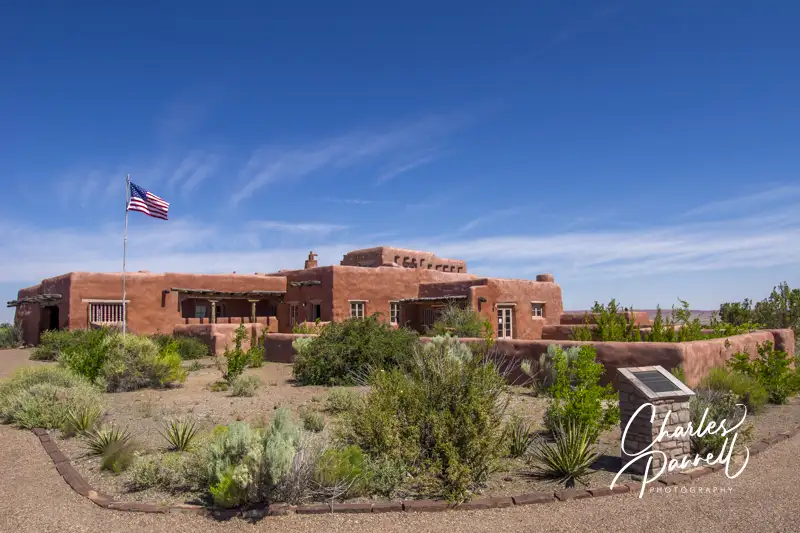
Located east of Winslow, the Painted Desert Inn (nps.gov/pefo/learn/historyculture/pdi.htm) officially opened in 1940 on the site of the former Stone Tree House, which once provided Route 66 travelers with food, souvenirs and lodging. Sadly the war brought an end to the boom days and the Painted Desert Inn was closed in 1942. Five years later the Fred Harvey Company took over management and hired Mary Colter to renovate the property; and the legendary Harvey Girls were brought to the Petrified Forest.
The property operated until 1963, but the inn was saved from the wrecking ball due to a massive public outcry. Finally in 1987 it was declared a National Historic Landmark, and the property was rehabilitated and returned to its former glory. Today you can see the old dining counter and lunch room, complete with vintage place settings. Access has also been improved over the years, with level access to most areas of the inn, and plenty of room for wheelchairs and scooters. After you’re done browsing through the inn, don’t miss the colorful desert view from the accessible viewpoint in back of the inn.
Belen Harvey House Belen, NM
Belen Harvey House in Belen, New Mexico
This 1910 Belen Harvey House (harveyhousemuseum.org) once contained a large lunch room, a formal dining room, a newsstand and an upstairs Harvey Girls dormitory. Today it houses a museum and an adjacent restaurant. There’s good access throughout the museum which contains lots of Harvey House memorabilia, including old photos, dishes, uniforms and even menus. There’s also a number of exhibits about the history of the railroad, and even some old railroad equipment on display. There’s no elevator access to the second floor, but the bulk of the exhibits up there focus on Belen history, rather than the Harvey Houses. As an added bonus the museum is staffed by volunteers who love to talk about the Harvey House heyday.
The Whistle Stop Café is also worth a stop while you are there. This casual eatery includes home made treats like muffins, carrot cake, cobbler and a variety of soups. Everything is delicious, and all proceeds from the café go to help support the museum.
Puye Rest House Espanola, NM
Puye Rest House in Espanola, New Mexico
Located well off the main train line in the Santa Clara Pueblo, this Harvey House was part of the Indian Detours program. Built on tribal land in the 1920s, the Puye Rest House (puyecliffdwellings.com/tours/harvey-house) hosted guests who traveled on the “Chili Line”, and were then transferred to the Santa Clara Pueblo in covered wagons in the early years, and in Model Ts in later years. The tours operated from 1925 to 1939, and the big attraction of this location was the hilltop cliff dwellings in back of the hotel.
Today the two buildings that made up the Harvey House are now an interpretive center and a gift shop, and although the cliff dwellings aren’t accessible, the buildings are very doable for wheelchair-users and slow walkers. Most of the exhibits in the interpretive center are focused on the history of the Santa Clara Pueblo, and the excavation of the cliff dwellings in 1907. Still it’s a chance to go inside the historic Harvey House building. There’s also a nice view of the cliff dwellings from the back porch. And if you just want to look at the outside of this historic building, it’s definitely worth the drive.
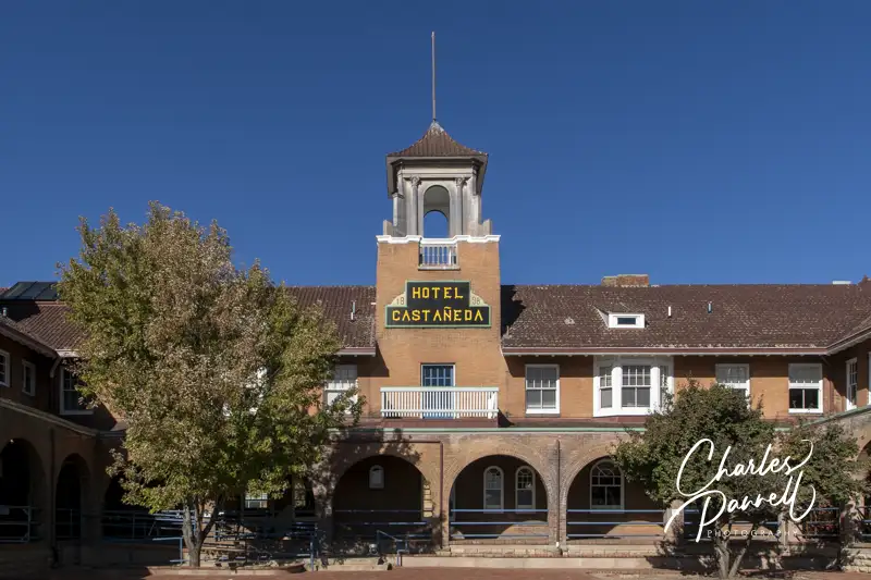
Castaneda House Las Vegas, NM
The Castaneda Hotel In Las Vegas, New Mexico
Last but certainly not least on our Harvey Houses of the Southwest tour is the Castaneda House (emerginghorizons.com/the-castaneda-hotel-a-wheelchair-accessible-harvey-house/), which opened in 1898. It closed in 1948 and was shuttered until a local investor purchased it in 2019. Today the restored property has the ambience of yesteryear, with the access features of modern times.
The Mission Revival style building once housed 37 guestrooms, a 108-seat dining room a 51-seat lunch counter, and a cluster of railroad offices. Today the renovated property has 22 suites; and if you look carefully in the rooms, you can see vague outlines of the former room borders on the floors. The hallway doors to the original rooms were also left intact — some now go to storage rooms, while others are merely decorative. And there’s also a nice wheelchair-accessible guest room with a roll-in shower. All in all, the Castaneda Hotel features the charm of the yesteryear, and the comforts and access features of today.
Barrier-Free Travel the Grand Canyon for Wheelchair-users and Slow Walkers
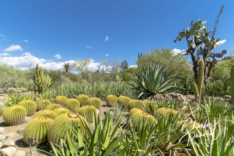
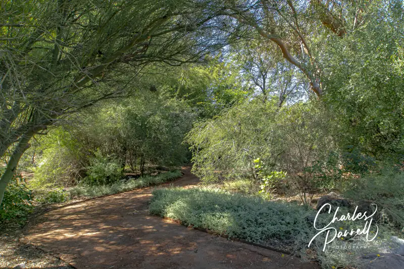
Located three miles west of Superior, Boyce Thompson Arboretum (btarboretum.org) is Arizona’s oldest and largest botanical garden. The 323-acre parcel is filled to the brim with plants from deserts around the world, and offers visitors an up-close-and-personal look at desert flora and fauna in the a variety of landscapes. From sheer mountain cliffs to a streamside forest, there’s a wide selection of habitats for wheelchair-users and slow walkers to explore. And since the park is just 65 miles east of Phoenix, it makes an excellent day trip from the city, as well as a fun Arizona road trip stop.
Plan a Picnic
Butterfly in the Demonstration Garden
Access is relatively good throughout this popular Arizona botanical garden, with accessible parking in front and barrier-free access over to the visitor center. Inside, there’s plenty of room to maneuver a wheelchair around the exhibits, and to the accessible restrooms, which are located in the rear of the building. There’s also barrier-free access to the gift shop, which offers souvenirs, gifts, drinks, snacks and sandwiches.
If you’d prefer to bring you own picnic lunch, accessible picnic tables are located near the Demonstration Garden, across from the visitor center. Accessible parking is located nearby, with a level path over to the shaded tables. It’s a pleasant, peaceful spot to enjoy a noontime repast.
Save some time to visit the Demonstration Garden after lunch. There’s level access throughout the garden which offers design and plant selection ideas for a variety of landscapes. Before you set out to explore the rest of the botanical garden, make sure you have an ample supply of water and a hat, as shade is in short supply, and the midday sun can be harsh.
Explore the Main Trail
Most of the Main Trail through the botanical garden is doable for wheelchair-users and slow walkers, as this hard-packed dirt trail is wide and fairly level. It begins near the visitor center and allows visitors access to a number of other gardens along the route.
The nearby Heritage Rose Garden also level pathways, and even though they are made of brick they’re still manageable. And don’t miss the Children’s Garden which features level access and boasts a fun water feature. The Taylor Family Desert Legume Garden is another good choice, as it’s is paved and showcases plants from the pea family. And although the trails in the outdoor Cactus Garden are a bit steep and bumpy, there are a few areas near the Main Trail that are doable for wheelchair-users and slow walkers.
The accessible section of this part of the Main Trail ends in about a mile, near Ayer Lake. From there it travels through the Upper Sonoran Natural Area, which has steep grades and a rocky pavement.
Another Main Trail Branch
Along the Main Trail at Boyce Thompson Arboretum
Even though Ayer Lake is the end of the line for one accessible trail, there’s still more for wheelchair-users and slow walkers to explore. From Ayer Lake, you can also double back and explore another branch of the main trail. Just head back toward the Taylor Family Desert Legume Garden, and connect to the other part of the Main Trail loop.
This section of the trail first trail passes through a patch of eucalyptus forest, with level pathways around the trees. The Herb Garden, which is just up the trail, is also fairly level, with plenty of room for wheelchair-users and slow walkers to navigate around the aromatic herbs. Just past the Herb Garden there’s barrier-free access to the suspension bridge, but the High Trail on the other side of the bridge is not accessible. The access on the Main Trail ends just past the pumphouse, where the trail connects to the rugged Upper Sonoran Natural Area.
All in all it’s about a three-mile round trip jaunt from the visitor center to Ayer Lake, over to the the Main Trail branch, and back to the visitor center. That said, if that’s too long, you can always explore the gardens near the visitor center, which offer a good overview of desert habitats. Either way Boyce Thompson Arboretum makes a fun and educational day trip for wheelchair-users and slow walkers.
Barrier-Free Travel the Grand Canyon for Wheelers and Slow Walkers
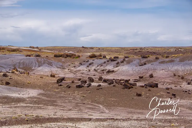
Located about an hour east of Winslow, Petrified Forest National Park (www.nps.gov/pefo/) boasts the largest concentration of petrified wood in the world. Not only does this Arizona gem offer some dazzling desert scenery, but it also includes a number of accessible trails and overlooks for wheelchair-users and slow walkers. And since the park is located right off Interstate 40, it’s an excellent addition to any Grand Canyon road trip.
The Basics
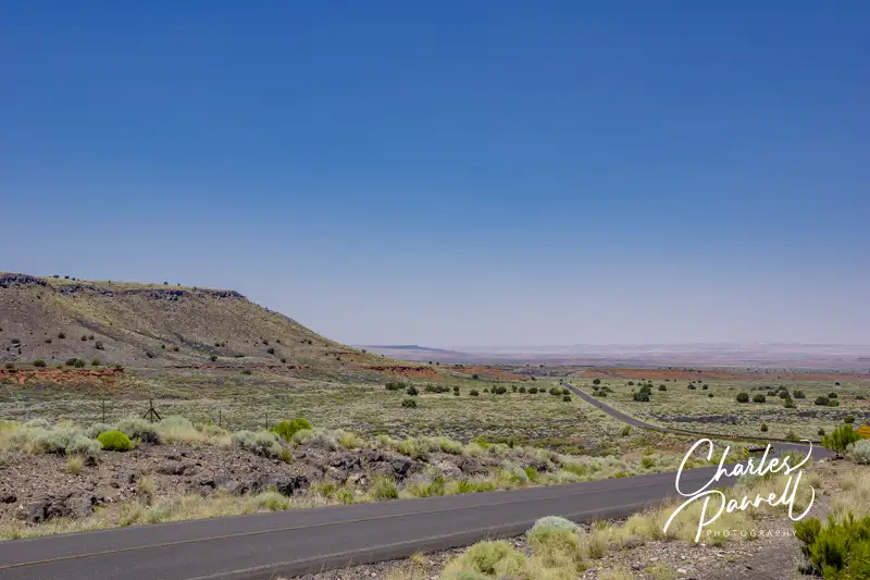
Windshield View on Highway 180
It’s easy to do a one-way jaunt through the park, stop at a few trails and viewpoints along the way, then reconnect to the highway and continue on your journey. If you’re traveling east, take the Highway 180 exit (exit 285) and use the south entrance of the park; and if you’re traveling west, take exit 311 and use the north entrance. Either way, after you’ve explored the 28-mile route, it’s simple to hop back on the interstate.
The whole drive takes an hour without any stops, and although there are some wonderful windshield views along the way, there are also some very scenic turnouts and sights that are definitely worth a stop. It should also be noted that the gates to this national park open at 8:00 a.m. and close at 5:00 p.m., so plan accordingly to avoid disappointment.
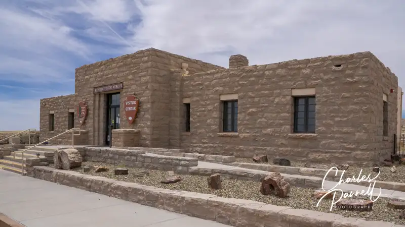
The Painted Desert Visitor Center, which is located near the north entrance, makes a good first stop in the park. Accessible parking is located near the entrance, with level access to the building. Inside there’s a small gift shop, a ranger information desk and accessible restrooms. Pick up a park map, then head out to explore this national treasure.
Views and More
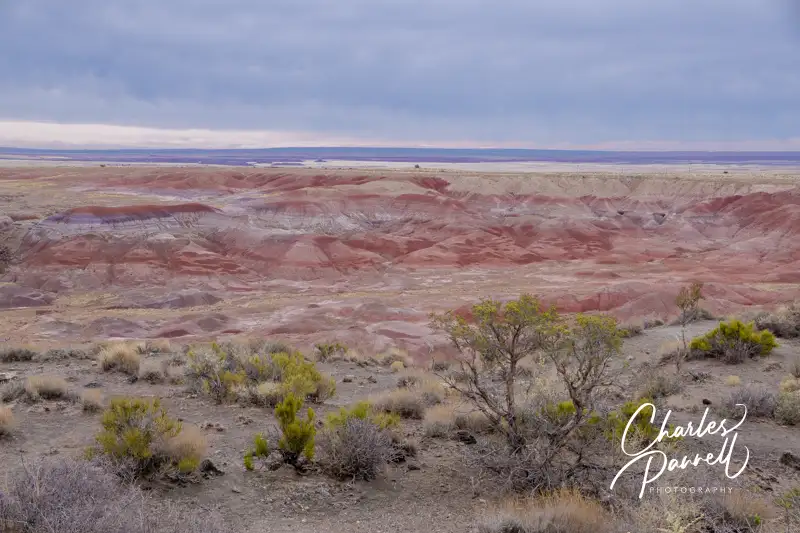
View at Tawa Point
Although there are no shortage of scenic views in the Petrified Forest National Park, make sure and stop at Tawa Point, just past the north entrance, for that first expansive view of the Painted Desert. Accessible parking is located near curb-cut access up to a short .1-mile paved trail out to the viewpoint. The last 20 feet of this path is a bit steep for manual wheelchair-users; however you can get a good view of the colorful desert from any place along the trail, or even from the parking lot.
The Painted Desert Inn, which is located just a half-mile up the road, is also worth a stop. This former Harvey House features accessible parking, and level access to the building. There inn houses a number of historic exhibits, but you just can’t beat the panoramic desert view from the second floor of this split-level structure. Additionally, there’s a 300-foot paved level pathway out to nearby Kachina Point, which offers an equally impressive desert view.
Painted Desert Inn
Another worthwhile stop is Puerco Pueblo, which is a few miles up the road, just past the railroad tracks. Accessible parking with curb-cut access up to the sidewalk is located near the accessible vault toilets. From there it’s about a 200-foot walk out to a .3-mile paved trail that circles the ruins of these ancestral Puebloan homes which were occupied from 1250 to 1380.
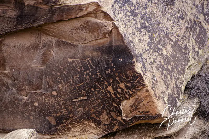
And don’t miss Newspaper Rock, which is short drive down the road. That site features a 200-foot paved level trail out to some Puebloan petroglyphs, which were created 2,000 years ago. There’s an accessible spotting scope at the overlook, which offers a good view of the 650-plus petroglyphs.
Petroglyphs on Newspaper Rock
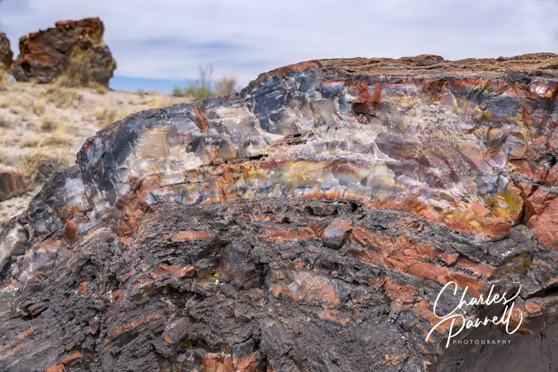
Petrified Wood Galore
Crystal Forest
There’s also a substantial collection of petrified wood sites — such as the Crystal Forest — along the main park road. Although a paved .8-mile trail leads past the petrified logs at this site, it’s got a section or two of 20% grade, so it’s not a good choice for wheelchair-users and slow walkers. That said there is a 400-foot paved level path that leads out to the trailhead, that offers a good overview of the remains of this ancient forest.
Rainbow Forest Visitor Center
Finally, don’t miss the Rainbow Forest, which is located just north of the south entrance. There’s accessible parking near the Rainbow Forest Visitor Center, with ramp access up to the front door. Inside there’s barrier-free access to the interpretive exhibits, ranger information desk and accessible restrooms. There’s also plenty of room for wheelchairs and scooters in the theater, where a movie about the park is shown throughout the day.
The Giant Logs Trail is located out back, and although this paved trail starts out level, the access ends 600 feet later at the Mather plaque, where steps block the rest of the route. Still, there’s a good view of the site from this point, or even from the back of the visitor center.
And if you’d like to grab a bite to eat before you hit the road, stop in at the curio shop at the far end of the parking lot. There’s level access to the shop, which offers snack items, gifts and souvenirs. All in all, Petrified Forest National Park is well worth the short detour off the interstate.
Petrified Tree in the Crystal Forest
Barrier-Free Travel the Grand Canyon for Wheelers and Slow Walkers
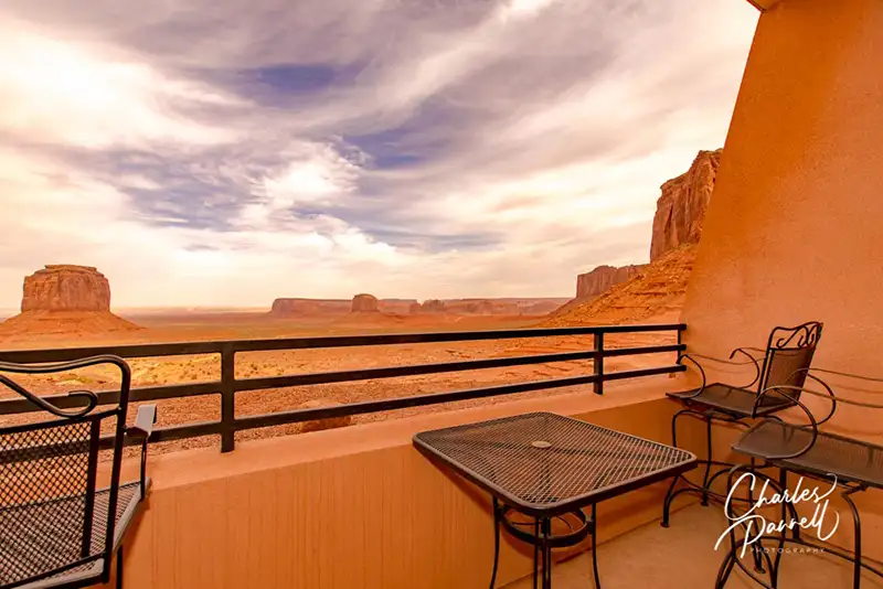
View from Room 103 at the View Hotel – Typical of all Rooms
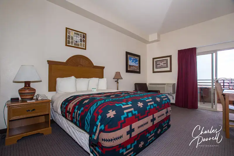
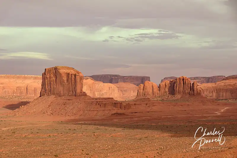
Monument Valley Tribal Park (navajonationparks.org/tribal-parks/monument-valley/) is a must-stop on any Southwestern road trip. Located on the Arizona-Utah border, this chunk of Navajo land boasts an impressive collection of sandstone formations towering as high as 1,000 feet above the rich red desert. And there’s no better place to stay in Monument Valley than at The View Hotel (monumentvalleyview.com). Not only does this property have a spacious wheelchair-accessible guest room, but it also offers panoramic desert views from private balconies.
Stay a Spell
Located off scenic Highway 163 at the end of Monument Valley Road, The View Hotel is pretty hard to miss, as there aren’t many structures in the area. And that’s also part of its beauty – isolation.
There’s plenty of accessible parking in front of the property, with level access to the lobby. Room 103, which features wide doorways, a lowered peephole and lever handles, is located just around the corner. It’s furnished with a 28-inch high king-sized bed, with wheelchair access on both sides. An easy chair, desk, refrigerator, microwave and a chest of drawers round out the furnishings.
Room 103 at the View Hotel
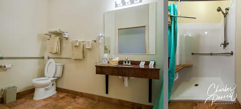
The bathroom is equipped with a roll-in shower with a built-in shower bench, grab bars and a hand-held showerhead. There is a slight one-inch lip on the shower threshold, but most people won’t have any problems with that. And with the full five-foot turning radius in the bathroom, there’s plenty of room to navigate even the largest wheelchair. The toilet blocks the transfer space to the shower bench, but if you can manage the slight shower lip on the opposite end, it shouldn’t be a problem.
Bathroom in Room 103
And then there’s the view from the balcony. It’s the perfect spot to enjoy a sunset.
There is good access throughout the public areas of the property as well, with elevator access to The View Restaurant and The Trading Post gift shop on the second floor. There’s also a loaner wheelchair available at the front desk.
Explore Monument Valley
Monument Valley
Known as “the place where the earth meets the sky”, there’s no shortage of scenic spots to enjoy in Monument Valley. The best place to begin your visit is at the Welcome Center and Navajo Market, which are located near the park entrance on Monument Valley Road.
Accessible parking is available in front of the Welcome Center, with level access up to the front door. Inside, there are interpretive exhibits about the history of the area, and about the many films and commercials that were made there. There’s barrier-free access throughout the building, and to the terrace out back, which offers a panoramic view of the Mitten Buttes and Merrick Butte. As you survey the landscape, you’ll begin to understand why so many westerns were filmed there. Next door there’s also accessible parking near the Navajo Market, which features a variety of local vendors, and boasts everything from artwork and jewelry, to baskets and even wood carvings. There is level access to many of the shops, and although some are a bit small, most vendors will happily bring items out to you.
Don’t miss the scenic 17-mile drive through Monument Valley. The unpaved and bumpy road begins near the hotel; and although four-wheel-drive isn’t required, it’s not advised for low clearance vehicles. Make sure and plan an adequate amount of time to complete the drive though, as you you can only go 5 mph. It’s also best to avoid the drive in the rain.
Finally, it’s important to remember that Monument Valley is on Navajo land, so national park passes are not valid there. There is an entrance fee to drive over the land, even if you are a hotel guest.
Barrier-Free Travel Utah National Parks for Wheelchair-users and Slow Walkers
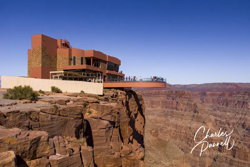
Located 130 miles southeast of Las Vegas, Grand Canyon West (grandcanyonwest.com) is not part of the US National Park System. It’s located on the Hualapai Reservation, and it’s home to the Grand Canyon Skywalk. This massive cantilever glass bridge extends out over the canyon rim and gives visitors a panoramic view of the canyon below. And although it’s outside the jurisdiction of the US government, this popular attraction offers good access for wheelchair-users and slow walkers. You can roll right out on the skywalk, and enjoy the beautiful canyon.
The Basics
Grand Canyon West is not located anywhere near the popular South Rim or the more remote North Rim of Grand Canyon National Park. It’s about a four-hour drive from the South Rim, and over six-hours from the North Rim. It’s definitely not a doable day trip from either of those sites. On the other hand, it’s just a two-hour drive from Las Vegas, so if you get an early start it makes a good day excursion from there.
It should be noted that because Grand Canyon West is not part of the US National Park system, national park passes are not valid for admission. Unfortunately the entrance price tag isn’t cheap either, but many consider it a treat and a once-in-a-lifetime experience. Still, leave room in your budget for the hefty entrance fee — usually about $100 per person.
On the Skywalk at Grand Canyon West
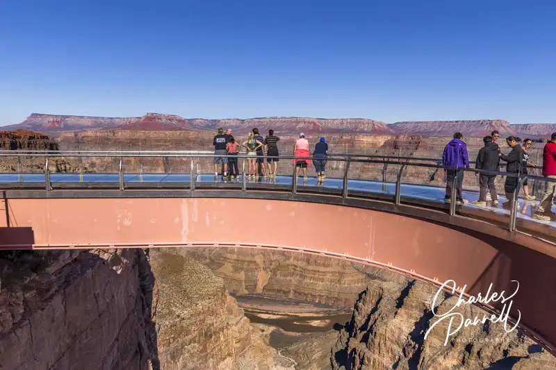
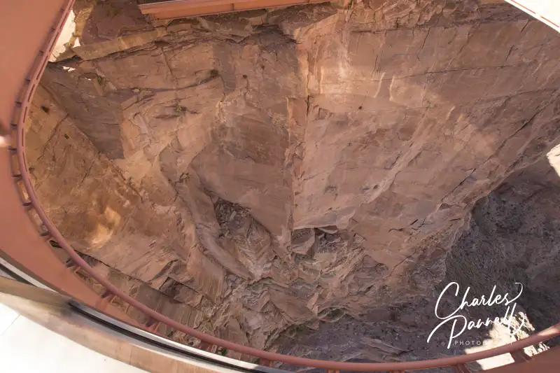
The Skywalk itself is considered an engineering marvel, as it extends out over the canyon and provides unobstructed views below. If you’re a little hesitant, don’t worry, as it’s incredibly sturdy. It’s built to withstand an 8.0 earthquake and winds up to 100 miles-per-hour. Still, looking straight down through the glass at the canyon floor may cause temporary vertigo in some people. If that happens, there’s one simple cure — just close your eyes.
The Grand Canyon Skywalk Experience
Vertical View from the Skywalk at Grand Canyon West
There are three main sections to Grand Canyon West, and a wheelchair-accessible shuttle connects these areas with the entrance plaza. Eagle Point is where the Skywalk is located, Guano Point is an abandoned mining site with some great canyon views, and Hualapai Point is home to the lodge, ranch and western village.
The Skywalk itself offers great wheelchair access. There’s ramp access up to the entrance and level access to the adjacent locker area. Nothing is permitted out on the skywalk, so all purses, cameras, backpacks and bags must be left in the lockers. Ambulatory visitors are asked to wear disposable booties on the skywalk, but there are no restrictions for wheelchair-users.
From the locker area, you can just roll right out to the skywalk, to get a bird’s eye view of the canyon below. It’s truly a breathtaking experience, and you can spend as much time on the skywalk as you want. And since cameras are prohibited on the skywalk, staff photographers are on hand to photograph visitors. Granted there’s an extra charge for this, but it’s a highly recommended souvenir.
It’s important to note that Grand Canyon West gets extremely busy with bus tours after 11 AM. Best bet for a more memorable experience is to get an alpine start and hit the Skywalk when it opens at 8 AM. Spend some time at Guano Point and Hualapai Point afterwards, enjoy the native dancers, browse through the crafts market and then have a bite to eat. And as you head out, the bulk of the crowds will be entering the site. Truly, it’s the most relaxing way to enjoy the Grand Canyon Skywalk.
Barrier-Free Travel the Grand Canyon for Wheelers and Slow Walkers
What’s not to like about a road trip? After all you get to set your own pace, explore a few off-the-beaten-track sights, and take in some gorgeous scenery. And although the highways and byways across the US offer a plethora of gorgeous windshield views, these seven western drives top my must-do list. Not only are they all easily doable in one day, but each route also features one don’t-miss wheelchair-accessible scenic highlight, where you can get out of the car and get up-close-and-personal with Mother Nature.
Tioga Road
Tenaya Lake on the Tioga Road in Yosemite National Park, California
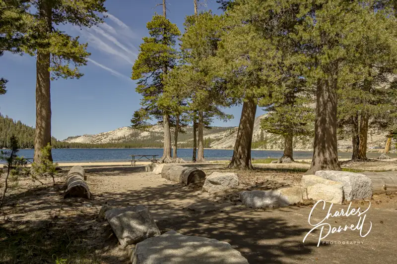
At the top of the Western road trips list is Tioga Road. This classic drive across the high country of Yosemite National Park (emerginghorizons.com/barrier-free-travelyosemite-sequoia-and-kings-canyon-national-parksfor-wheelers-and-slow-walkers/#itins), connects Crane Flat near Yosemite Valley with Highway 395 in Lee Vining. Along the way you’ll be treated to some great views of Tenaya Lake and Tuolumne Meadows, as you pass by isolated snowfields and travel over the 9,943-foot high mountain pass.
Take some time to get out of your car at the east end of Tenaya Lake. Located at 8,150 feet, this alpine lake offers a short wheelchair-accessible path down to the lakeshore, where you’ll find an accessible picnic table on an asphalt pad. It’s the perfect spot for a secluded picnic lunch.
Keep in mind that timing is extremely important along this route though, as heavy snow makes the road impassable during the winter months. Fall is a lovely time on Tioga Road, but try and hit it before the end of October. Mountain weather is unpredictable and this road has closed as early as mid-October.
Kings Canyon Scenic Byway
Grizzly Falls Picnic Area on the Kings Canyon Scenic Byway in Kings Canyon National Park, California
Located in the National Forest just outside of Kings Canyon National Park, The Kings Canyon Scenic Byway begins just north of Grant Grove on Highway 180. This scenic route travels through a pine forest before it descends alongside granite walls deep into magnificent Kings Canyon. After the road reaches the canyon floor, it follows the roaring Kings River and then it re-enters the park just past Grizzly Falls Picnic Area.
There are several viewpoints with interpretive plaques along the way, and although none of them have striped parking, all of them are paved and level, with plenty of room to deploy a ramp when parked parallel. McGee View offers a look at the destruction and rebirth of the forest since the 2015 Round Fire, while Yucca Point and Junction View give visitors a close look at the massive canyon walls. The Boyden Cave site is worth a stop too, as even though the cave tours haven’t operated for many years (and they are not accessible), you’ll still get a good view of the mighty Kings River from either side of the road.
And don’t miss the Grizzly Falls Picnic Area . A short paved loop leads from the parking area, up around several accessible picnic tables on cement pads. It’s about 100 feet up to the interpretive plaque near the base of the falls, but after that you’ll have to scramble over the rocks to get any closer. Still, there’s a great view of the falls from the plaque, the picnic tables and even the parking area. Even if you don’t stop for lunch, be sure and pop in for the view.
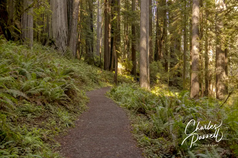
Newton B. Drury Parkway
Prairie Creek Foothill Trail in the Newton B. Drury Parkway in Prairie Creek Redwoods State Park, California
Next up on our Western road trips list is a drive through some old growth redwoods on the Newton B. Drury Parkway, which bisects Prairie Creek Redwoods State Park (www.parks.ca.gov/?page_id=415) in Northern California.
Although there are some nice windshield views along the 10-mile route, you’ll definitely want to stop for a close look at the Big Tree, near the visitor center. There’s accessible parking and restrooms near this wayside exhibit, and a 100-yard paved path to the tree. There’s also ramp access up to this 304-foot giant, which towers over the surrounding forest.
If you’d like to take a hike through the grove, the accessible Prairie Creek Foothill Trail is the perfect choice. This 2.3-mile loop trail starts just to the right of the visitor center and follows fern-lined Prairie Creek for 1.2 miles. The trail is hard-packed dirt, and although it’s not totally level, the grade is up to code and there are level spots every 30 feet, with benches to rest along the way.
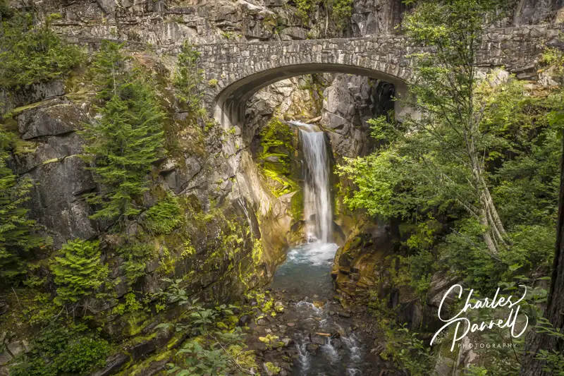
Christine Falls on the Longmire to Sunrise Drive in Mount Rainier National Park
One of the most accessible things to do in Mount Rainier National Park (emerginghorizons.com/barrier-free-travel-washington-national-parks-for-wheelers-and-slow-walkers/#itins) is to take the 56-mile scenic drive from Longmire to Sunrise. Although the drive takes about two-and-a-half hours straight through, it’s best to allow a whole day for it, as you’ll want to stop and enjoy the views along the way, as well as spend some time on top. And although the windshield views are breathtaking on the drive up, they are even more spectacular on the trip back down the hill.
Highlights along the way include Ricksecker Point Loop Drive, Narada Falls and Reflection Lakes; however, the pièce de résistance is Christine Falls. It’s located on the left side of the road, just past Longmire; but if you take time to admire it from your car, you’ll completely miss the parking area on the right side.
Up at the top, be sure and stop in at the Sunrise Visitor Center. The front entrance has steps, but there’s good signage to the accessible side entrance. Inside, there’s plenty of room to navigate a wheelchair around the interpretive exhibits. Best of all, you can get an absolutely amazing view of Mt. Rainier from the scope that’s trained on the mountain inside the visitor center.
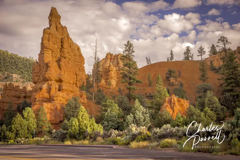
Scenic Byway 12
Roadside View in Red Canyon on Scenic Byway 12, Utah
Located in Southern Utah, Scenic Byway 12 travels west from Torrey to Highway 89, and offers views of Kodachrome Basin, Grand Staircase-Escalante National Monument, Glen Canyon National Recreation Area and the Dixie National Forest. And although this byway was a dirt road until 1985, the 124-mile route has been repeatedly described as one of the most diverse, remote and ruggedly beautiful landscapes in the country.
From Torrey to Boulder the road winds through a Ponderosa Pine and Aspen forest, where the fall foliage show is second-to-none. And from Boulder west, the route passes through Grand Staircase-Escalante National Monument and offers a breathtaking canyon view.
One of the most striking sights along the route is Red Canyon (emerginghorizons.com/spend-the-night-in-red-canyon-village/) , which is located near Highway 89. Often called “Little Bryce”, Red Canyon is filled with pullouts, and there’s even a nice paved bicycle trail on the south side of the highway. The eight-mile bicycle trail is paved and fairly level for most of the way, but there are also a few undulating and steeper sections. It’s not technically wheelchair-accessible because of the grade, but some handcyclists and manual wheelchair-users with good upper body strength may be able to manage it. That said, since a good chunk of the trail is level, it’s worth a try, and you can always turn back if it becomes too steep.
And just off Highway 12 in Boulder, there’s the scenic Burr Trail which offers a lovely drive through Grand Staircase-Escalante National Monument. And as with most scenic drives, the view is entirely different on the return trip.
Historic Route 66
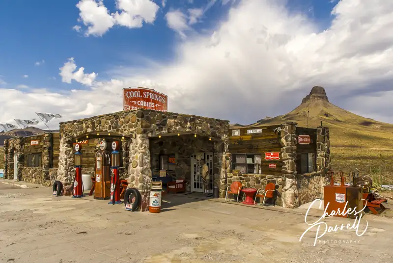
Cool Springs, Arizona on Route 66
Rounding out our Western road trips is Historic Route 66. Fondly known as the Mother Road, Route 66 (www.historic66.com) began as a series of dirt trails and unnamed roads cobbled together to create America’s first interstate highway. Today, the road has been replaced by Interstate 40; however you can still jump off the interstate and explore sections of the old road (emerginghorizons.com/wheelchair-accessible-route-66-a-great-grand-canyon-side-trip/). And one of the best places to begin this drive is in Kingman, Arizona.
Take the West Beale Street exit from Interstate 40, bear right at the Y, and follow the signs through Kingman to Oatman on Historic Route 66. Once outside of town, you’ll notice a pleasant lack of traffic as you make your way across the Sacramento Wash to Cool Springs, which is scantily more than a wide spot in the road.
From Cool Springs the Mother Road climbs up Gold Hill to Sitegreaves Pass. Hairpin turns and sheer drop-offs are commonplace on this stretch of the road, and there’s a noticeable lack of guard rails along the way. On the plus side, there’s no shortage of awesome views, including a great one near the 30-mile marker. After you reach the summit, the downhill drive is just as exhilarating, with plenty of twists and turns along the way. As you breathe that final sigh of relief, you’ll roll into Oatman. Years ago, the miners used burros to work the gold mines, and today their descendants roam the streets. Take an apple or two to feed them and you’ll be the center of attention.
From Oatman it’s another 26 miles to Topock, where you can rejoin Interstate 40. Although this Route 66 detour is just 140 miles long, it’s a wonderful opportunity to turn back the clock and step into the past.
Barrier-Free Travel Yosemite, Sequoia and Kings Canyon National Parks for Wheelers and Slow Walkers
With 63 parks in the US National Park System, it’s really hard to choose a favorite. That said, wheelchair-access plays a big part in my top choices. But there has to be more than just access to a visitor center or a few overlooks to make my list. Diversity also plays into my choices, but so does the quality of the visit. Accessible overnight lodging has to be in that mix too.
And let’s not forget about the price of popularity. Sadly, with so many visitors flocking to some of these national treasures, sometimes it feels like you are lined up for a popular ride at an iconic theme park at some national parks. That definitely takes away from the natural experience. So taking that all these factors into consideration, here are my five favorite wheelchair-accessible national parks .
Glacier National Park (emerginghorizons.com/barrier-free-travel-glacier-yellowstone-and-grand-teton-national-parks-for-wheelchair-users-and-slow-walkers/#itin-1) tops my list of wheelchair-accessible national parks, not only for the beautiful scenery and variety of accessible lodging choices, but for its ease of access without a vehicle. That’s right, you can take the Amtrak Empire Builder to this iconic national park, and then hop on the visitor shuttle to your in-park lodge and then book a Red Bus tour to see the park. And the good news is, that all of these transportation options are wheelchair-accessible. Plus, you don’t have to worry about getting an entrance reservation (emerginghorizons.com/national-park-entrance-reservations-required-in-2024/) if you stay in the park. So ditch your car and visit this Montana gem this summer!
Big Trees Loop at Mariposa Grove in Yosemite National Park
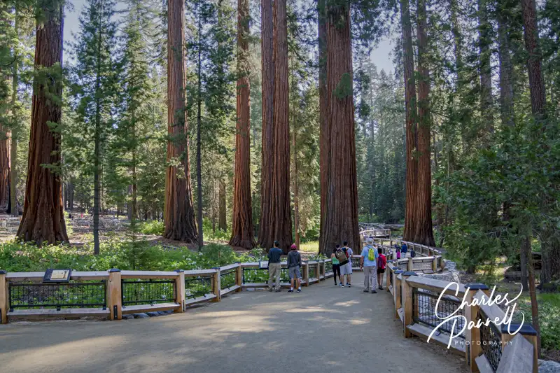
Yosemite (emerginghorizons.com/barrier-free-travelyosemite-sequoia-and-kings-canyon-national-parksfor-wheelers-and-slow-walkers/#itins holds a special place in my heart, as I grew up near there and spent a good chunk of my adult life in the area. Nothing beats the grandeur of Yosemite Falls or Half Dome; however Yosemite Valley can get extremely crowded, even in the off season. One way to dodge some of the crowds is to plan an excursion to a non-valley site. And my top pick for that is Mariposa Grove. Located near the South Entrance of the park, Mariposa Grove is home to over 500 mature giant sequoias. And thanks to upgrades over the years, there are two wheelchair-accessible trails through this often overlooked corner of the park.
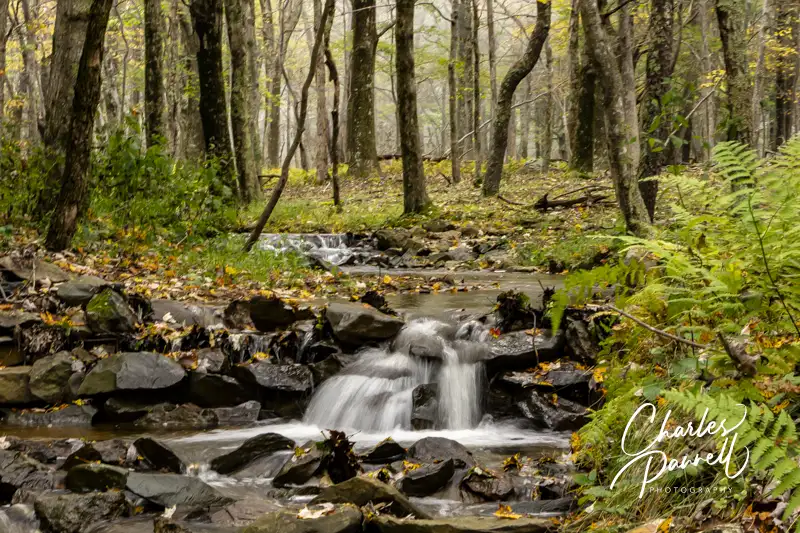
Next up on my list of favorite wheelchair-accessible national parks is Shenandoah National Park. This Northwestern Virginia national park is chocked full of beautiful views, and the wildflower blooms in the summer are absolutely gorgeous. There’s also a beautiful 1.3-mile accessible trail that runs through a wooded area and over a boardwalk. And the trail is close to Skyland, an excellent choice for wheelchair-accessible lodging. The property boasts a spacious accessible room with a roll-in shower and the restaurant offers more great views. It’s the perfect spot to unwind and spend a night or two.
Forces of the Northern Range Boardwalk in Yellowstone National Park
I love Yellowstone National Park (emerginghorizons.com/barrier-free-travel-glacier-yellowstone-and-grand-teton-national-parks-for-wheelchair-users-and-slow-walkers/#itin-1), and I’m not alone with that opinion. It’s an incredibly busy national park. That said, if you get there early you can enjoy a somewhat uncrowded experience at Old Faithful, one of the park’s biggest draws. But there’s much more to see beyond the iconic geyser, and even a few places that are a little off-the-beaten-path. Some of my wheelchair-accessible favorites are West Thumb Geyser Basin, Frying Pan Spring and the Forces of the Northern Range Boardwalk. And one of my friends even had an accessible hunting adventure there (emerginghorizons.com/a-disabled-hunting-adventure-stalking-big-game-out-west/). Truly, they sky’s the limit as far as accessible things to do in the nation’s first national park.
Rounding out my list of favorite wheelchair-accessible national parks is and oldie but goodie — Grand Canyon National Park (emerginghorizons.com/the-grand-canyon-for-wheelers-and-slow-walkers/#itin-1). More specifically, the South Rim of this iconic national park. I love it not only because of the accessible canyon views and lodging options, but also because it’s another national park that you can see without a car. You can take Amtrak’s Southwest Chief to Flagstaff and connect with an accessible shuttle to the park. Alternately, you can take an Amtrak thruway bus to Williams and hop on the equally accessible Grand Canyon Railway and ride it to the park. Add in an overnight at the Grand Canyon Railway Hotel, and you have a truly accessible car-free Grand Canyon package. And once you’re in the park, there’s an accessible shuttle that stops at the most popular South Rim sites. Enjoy the scenery and leave the driving to someone else in this beautiful national park.
Barrier-Free Travel National Park Lodges for Wheelers and Slow Walkers
Population 385
Billed as the oldest continually inhabited mining town in Arizona, Chloride is located about 25 miles north of Kingman. Surrounded by mineral rich hills, the town was named for the silver chloride deposits found nearby. Today this ghost town’s claim to fame is unusual yard art. The town is pretty quiet so you can just roll down the level streets to explore the growing yard art collection. As far as wheelchair access goes, there’s one accessible parking space near the Mineshaft Market on Tennessee Street, with ramp access to the front door. Yesterdays Restaurant, which is located on 2nd Street, also has accessible parking with level access to the restaurant. It’s kind of a fun little place, and it makes a good stop on the way to Grand Canyon West. And they even have gunfights every now and then.

 The Grand Canyon is definitely a must-see on the life bucket list. Most people arrive at this popular national park by car, as there’s not exactly an international airport on the rim. That said, there’s an alternative way to get to the South Rim of the Grand Canyon – ride the rails on the Grand Canyon Railway (www.thetrain.com)). And not only is this journey scenic, it’s also wheelchair-accessible. So check out this fun excursion on your next Arizona visit.